Category:Ridderstraat 186, Culemborg
Jump to navigation
Jump to search
| Object location | | View all coordinates using: OpenStreetMap |
|---|
 | |||||
| Upload media | |||||
| Instance of | |||||
|---|---|---|---|---|---|
| Location | Culemborg, Gelderland, Netherlands | ||||
| Street address |
| ||||
| Located on street | |||||
| Heritage designation |
| ||||
 | |||||
|
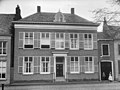
This is a category about rijksmonument number 11584
|
| Address |
|
Media in category "Ridderstraat 186, Culemborg"
The following 5 files are in this category, out of 5 total.
-

-
 Kleine Kerkstraat Culemborg...jpg 4,770 × 3,177; 4.73 MB
-
 Ridderstraat Culemborg..jpg 4,770 × 3,177; 5.34 MB
-
 Voorgevel - Culemborg - 20052043 - RCE.jpg 1,200 × 799; 222 KB
-