Category:Roche, Cornwall
Jump to navigation
Jump to search
village and civil parish in Cornwall, England, UK  | |||||
| Upload media | |||||
| Instance of | |||||
|---|---|---|---|---|---|
| Location | Cornwall, South West England, England | ||||
| Population |
| ||||
| Elevation above sea level |
| ||||
 | |||||
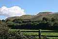
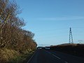
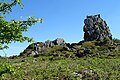
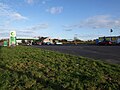
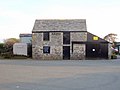
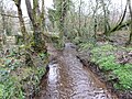
English: Roche (pronounced Roach) is a village and parish in mid- Cornwall, United Kingdom. The village gets its name from a granite outcrop east of the village. Roche is the Norman-French word for Rock.
Subcategories
This category has the following 16 subcategories, out of 16 total.
B
- Belowda (15 F)
- Bilberry, Cornwall (1 F)
C
- Carbis (1 F)
H
- Higher Town, Roche (1 F)
M
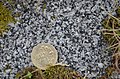
- Minerals of Roche (6 F)
R
- Roche Brass (4 F)
- Roche Cemetery (6 F)
- Roche War Memorial (3 F)
S
- Streets in Roche, Cornwall (22 F)
T
- Tregoss (1 F)
V
Media in category "Roche, Cornwall"
The following 84 files are in this category, out of 84 total.
-

-
 Beacon Mine - geograph.org.uk - 61839.jpg 640 × 480; 70 KB
-

-
 Bungalows at Higher Trezaise - geograph.org.uk - 2853281.jpg 800 × 600; 266 KB
-
 Car Park and Tennis Courts - geograph.org.uk - 5783485.jpg 640 × 427; 356 KB
-
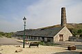
 Carbis Wharf - former china clay dry - geograph.org.uk - 3367599.jpg 640 × 427; 80 KB
-
 Carbis Works - geograph.org.uk - 3758102.jpg 640 × 424; 205 KB
-
 Carne Cottage - geograph.org.uk - 195999.jpg 640 × 480; 98 KB
-

-
 China Clay Waste Tips - geograph.org.uk - 5092112.jpg 640 × 480; 51 KB
-
-
 China clay workings near Whitemoor, Cornwall - geograph.org.uk - 2274004.jpg 1,024 × 692; 208 KB
-
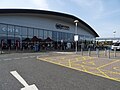
 Cornwall Services - geograph.org.uk - 5783459.jpg 640 × 427; 264 KB
-
 Cornwall Services - geograph.org.uk - 6141755.jpg 1,024 × 768; 203 KB
-
 Cornwall Services - geograph.org.uk - 6141759.jpg 1,024 × 768; 190 KB
-
 Cornwall Services - geograph.org.uk - 6538706.jpg 3,898 × 2,193; 1.59 MB
-
 Cows on the downs - geograph.org.uk - 6283011.jpg 800 × 600; 97 KB
-
 Former chapel near Tremodrett - geograph.org.uk - 5596341.jpg 640 × 453; 94 KB
-
 Goodyear 45-65r45 tyre - geograph.org.uk - 3477630.jpg 640 × 424; 72 KB
-
 Goonbarrow Spoil Tip - geograph.org.uk - 64112.jpg 640 × 480; 53 KB
-
 Goss Moor, Roche - geograph.org.uk - 6151335.jpg 1,024 × 768; 262 KB
-

-
-

-
 Hensbarrow Beacon trig point - geograph.org.uk - 6282996.jpg 800 × 600; 117 KB
-
 Hensbarrow Downs - geograph.org.uk - 6282985.jpg 800 × 600; 115 KB
-
 Imery's Little John Pit - geograph.org.uk - 3477623.jpg 640 × 424; 75 KB
-
 Junction near Trezaise - geograph.org.uk - 4431814.jpg 4,601 × 2,336; 4 MB
-
 Landscape Near Bugle - geograph.org.uk - 4624270.jpg 2,784 × 1,568; 2.12 MB
-
 Level Crossing on Road to Tregoss - geograph.org.uk - 6203676.jpg 640 × 480; 97 KB
-
 Level crossing on Tregoss Moor - geograph.org.uk - 5596393.jpg 640 × 480; 93 KB
-
 Little Johns pit - geograph.org.uk - 1836872.jpg 640 × 480; 77 KB
-
 Lorry Park and Turbine - geograph.org.uk - 5783453.jpg 480 × 640; 227 KB
-
 Manicured Lawn - geograph.org.uk - 5783457.jpg 640 × 427; 134 KB
-

-
 Mayfair Park - geograph.org.uk - 195989.jpg 640 × 480; 65 KB
-
 Motorway Services - geograph.org.uk - 5783446.jpg 640 × 427; 274 KB
-
 Old china clay works at Carbis - geograph.org.uk - 1228056.jpg 640 × 482; 165 KB
-

-

-

-

-
 Pharmacy in Fore Street Roche - geograph.org.uk - 5596338.jpg 640 × 480; 85 KB
-
 Planting on Harmony Close, Roche, Cornwall - July 2023.jpg 3,856 × 2,722; 1.89 MB
-
 Post box, Harmony Road, Roche, Cornwall - July 2023.jpg 2,722 × 3,856; 1.67 MB
-
-
 Pylons on Tregoss Moor - geograph.org.uk - 5876901.jpg 640 × 480; 64 KB
-

-
 Recreation Ground Roche as seen from Roche Rock - geograph.org.uk - 6456299.jpg 1,799 × 1,199; 378 KB
-
 Road to Hensbarrow Downs - geograph.org.uk - 2853287.jpg 600 × 800; 275 KB
-
 Roche cricket ground.jpg 3,518 × 2,593; 3.86 MB
-
 Roche Cricket Pitch - geograph.org.uk - 5783487.jpg 640 × 427; 223 KB
-
 Roche railway station - geograph.org.uk - 5746966.jpg 1,024 × 843; 195 KB
-
 Roche Rock from Roche - geograph.org.uk - 966812.jpg 640 × 480; 53 KB
-
 Roche Rocks - geograph.org.uk - 5783463.jpg 480 × 640; 440 KB
-
 Roche Rocks - geograph.org.uk - 5783473.jpg 480 × 640; 432 KB
-
 Roche Rocks - geograph.org.uk - 5783477.jpg 457 × 640; 376 KB
-
 Roche Rocks - geograph.org.uk - 5783483.jpg 640 × 427; 390 KB
-
 Roche, by the road to Carbis - geograph.org.uk - 2428237.jpg 640 × 429; 399 KB
-
 Roche, Carbis Brickworks - geograph.org.uk - 2428202.jpg 640 × 427; 359 KB
-

-
 Scarecrow Festival Roche, Cornwall - July 2023 (1).jpg 2,835 × 3,806; 2.38 MB
-
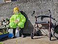 Scarecrow Festival Roche, Cornwall - July 2023 (2).jpg 4,032 × 3,024; 4.03 MB
-
 Scrubby commonland near Little Brynn - geograph.org.uk - 5596438.jpg 640 × 480; 61 KB
-
-
 Service station at Victoria - geograph.org.uk - 5596344.jpg 640 × 480; 41 KB
-
-
 Spoil Heap at Goonbarrow China Clay Works - geograph.org.uk - 4431748.jpg 2,615 × 2,148; 2.95 MB
-
 St Michael's Chapel - geograph.org.uk - 5783466.jpg 640 × 427; 291 KB
-
 St Michael's Chapel, Roche Rock - geograph.org.uk - 6456308.jpg 1,799 × 1,199; 512 KB
-
 St Michael's Chapel, Roche Rock - geograph.org.uk - 6456316.jpg 1,799 × 1,199; 520 KB
-

-
 Stream below Brynn Mill - geograph.org.uk - 5597922.jpg 640 × 480; 148 KB
-
 Tips in the Downs - geograph.org.uk - 170320.jpg 640 × 426; 57 KB
-
 Tormaline Schorl - geograph.org.uk - 3133184.jpg 640 × 424; 310 KB
-
 Track leading to Little Brynn - geograph.org.uk - 5876898.jpg 640 × 480; 120 KB
-
 UK postbox queen Victoria Cornwall (GB) ©DJE 2006.JPG 1,649 × 2,728; 2.97 MB
-
 View from Cornwall Services - geograph.org.uk - 5345335.jpg 1,600 × 1,067; 213 KB
-
 Viewing area at Little Johns Pit - geograph.org.uk - 1836905.jpg 640 × 480; 87 KB
-
 Waste tips near Hensbarrow Beacon - geograph.org.uk - 1854382.jpg 640 × 426; 160 KB
-

-
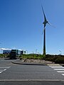
 Wind Turbine - geograph.org.uk - 5783451.jpg 480 × 640; 364 KB
-
 Cleers Hill - geograph.org.uk - 342757.jpg 640 × 427; 85 KB
-
 Roche Millennium Monument - geograph.org.uk - 342518.jpg 640 × 480; 157 KB


.jpg)


.jpg)
.jpg)


_%C2%A9DJE_2006.JPG)


