Category:Roman Catholic Church (Loenen)
Jump to navigation
Jump to search
| Object location | | View all coordinates using: OpenStreetMap |
|---|
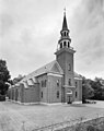
church in Loenen, Apeldoorn, Netherlands  | |||||
| Upload media | |||||
| Instance of |
| ||||
|---|---|---|---|---|---|
| Location | Loenen, Apeldoorn, Gelderland, Netherlands | ||||
| Street address |
| ||||
| Located on street |
| ||||
| Heritage designation |
| ||||
 | |||||
Nederlands: Antonius Abt - anno 1848
Toren:
|
This is a category about rijksmonument number 8183
|
| Address |
|
Media in category "Roman Catholic Church (Loenen)"
The following 6 files are in this category, out of 6 total.
-
 20170921 Zicht op Loenen.jpg 2,592 × 1,728; 1.03 MB
-
 Hoofdstraat, aanzicht, exterieur - Loenen - 20141285 - RCE.jpg 804 × 1,200; 169 KB
-
 Interieur, aanzicht orgel, orgelnummer 894 - Loenen - 20417193 - RCE.jpg 882 × 1,200; 168 KB
-
 Loenen, de katholieke kerk RM8183 IMG 3243 2018-05-09 11.44.jpg 5,234 × 3,489; 11.7 MB
-
 Overzicht noordwestgevel met kerktoren - Loenen - 20359678 - RCE.jpg 952 × 1,200; 190 KB
-
 RKLoenen8183.JPG 4,288 × 2,848; 4.3 MB


