Category:Rope, Cheshire
Jump to navigation
Jump to search
English: Rope is a scattered settlement and civil parish in the unitary authority of Cheshire East and the ceremonial county of Cheshire, England. It lies immediately to the south of Crewe, with the centre of the parish being around 2¼ miles from the centre of Crewe. Nearby villages include Shavington, Willaston and Wistaston. The civil parish has a total population of just over 2150.
village and civil parish in Cheshire, United Kingdom  | |||||
| Upload media | |||||
| Instance of | |||||
|---|---|---|---|---|---|
| Location | Cheshire East, Cheshire, North West England, England | ||||
 | |||||
Media in category "Rope, Cheshire"
The following 15 files are in this category, out of 15 total.
-

-
 Barn at Rope Farm - geograph.org.uk - 2130652.jpg 1,866 × 1,392; 447 KB
-
 Barns at Rope Farm - geograph.org.uk - 2248587.jpg 1,024 × 768; 807 KB
-
 Eastern Road - geograph.org.uk - 1342654.jpg 640 × 431; 67 KB
-
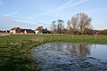 Mere, Rope.jpg 1,200 × 800; 844 KB
-
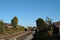
 Railway, Rope.jpg 1,200 × 800; 456 KB
-
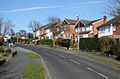 Rope - Bankfield Avenue.jpg 640 × 419; 146 KB
-
 Rope Farm, Shavington - geograph.org.uk - 2948088.jpg 2,000 × 1,333; 365 KB
-
 Shavington High School - geograph.org.uk - 2248592.jpg 1,024 × 686; 899 KB
-
 Shavington High School - geograph.org.uk - 2248595.jpg 1,024 × 702; 636 KB
-
 Shavington High School, Rope - geograph.org.uk - 323227.jpg 640 × 500; 114 KB
-
 Shavington High School, Rope.jpg 1,000 × 577; 383 KB
-
 Swill Brook, Rope.jpg 817 × 1,200; 770 KB
-
 Train approaching Willaston level crossing - geograph.org.uk - 2130746.jpg 2,001 × 1,349; 494 KB
-
 Berkeley Primary School, Wistaston - geograph.org.uk - 373053.jpg 640 × 436; 136 KB


