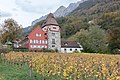
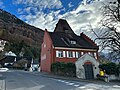
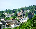
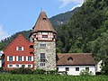
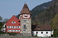
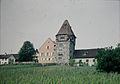
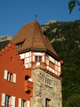
Category:Rotes Haus (Vaduz)
Jump to navigation
Jump to search
|
This is a category about cultural heritage monument of Liechtenstein, number: 5512.0064
|
| Object location | | View all coordinates using: OpenStreetMap |
|---|
building in Vaduz, Liechtenstein  | |||||
| Upload media | |||||
| Instance of | |||||
|---|---|---|---|---|---|
| Location | Vaduz, Liechtenstein | ||||
| Street address |
| ||||
| Heritage designation | |||||
 | |||||
Media in category "Rotes Haus (Vaduz)"
The following 22 files are in this category, out of 22 total.
-
 2018-10-05 Liechtenstein, Vaduz, Rotes Haus (KPFC) 01.jpg 6,016 × 4,010; 9.28 MB
-
 2018-10-05 Liechtenstein, Vaduz, Rotes Haus (KPFC) 02.jpg 5,226 × 3,700; 9.21 MB
-
 2018-10-05 Liechtenstein, Vaduz, Rotes Haus (KPFC) 03.jpg 6,016 × 4,010; 12.08 MB
-
 2018-10-05 Liechtenstein, Vaduz, Rotes Haus (KPFC) 04.jpg 6,016 × 4,010; 8.47 MB
-
 2018-10-05 Liechtenstein, Vaduz, Rotes Haus (KPFC) 05.jpg 6,016 × 4,010; 9.11 MB
-
 2018-10-05 Liechtenstein, Vaduz, Rotes Haus (KPFC) 06.jpg 5,167 × 3,678; 5.86 MB
-
 2018-10-05 Liechtenstein, Vaduz, Rotes Haus (KPFC) 07.jpg 6,016 × 4,010; 8.63 MB
-
 2018-10-05 Liechtenstein, Vaduz, Rotes Haus (KPFC) 08.jpg 6,016 × 4,010; 8.64 MB
-
 2018-10-05 Liechtenstein, Vaduz, Rotes Haus (KPFC) 09.jpg 4,010 × 6,016; 8.53 MB
-
 2018-10-05 Liechtenstein, Vaduz, Rotes Haus (KPFC) 10.jpg 6,016 × 4,010; 8.46 MB
-
 2018-10-05 Liechtenstein, Vaduz, Rotes Haus (KPFC) 11.jpg 6,016 × 4,010; 11.59 MB
-
 Casa Roja, Vaduz, Liechtenstein, 2022-10-23, DD 64.jpg 7,971 × 5,314; 9.06 MB
-
 Casa Roja, Vaduz, Liechtenstein, 2022-10-23, DD 66.jpg 8,173 × 5,449; 9.37 MB
-
 RedHouseNMov2023.jpg 4,032 × 3,024; 3.42 MB
-
 Rotes Haus in Vaduz.jpg 2,841 × 2,249; 3.14 MB
-
 Rotes Haus Vaduz.JPG 4,989 × 3,741; 4.18 MB
-
 Vaduz - 31032014 - Rotehaus.jpg 4,779 × 3,159; 14.85 MB
-
 Vaduz in 1958 02.JPG 2,222 × 1,558; 776 KB
-
 Vaduz Rotes Haus.jpg 5,848 × 3,828; 22.05 MB
-
 Vaduz, Liechtenstein (40331526233).jpg 1,382 × 1,382; 2.05 MB
-
 Vaduz2005.JPG 719 × 830; 119 KB
-
 Vaduz3.png 1,944 × 2,592; 6.98 MB
_01.jpg)
_02.jpg)
_03.jpg)
_04.jpg)
_05.jpg)
_06.jpg)
_07.jpg)
_08.jpg)
_09.jpg)
_10.jpg)
_11.jpg)


.jpg)
