Category:Routh, East Riding of Yorkshire
Jump to navigation
Jump to search
English: Routh is a village and civil parish in the East Riding of Yorkshire, England. It is situated is approximately 4 miles (6.4 km) north east of Beverley, lying on the A1035 road.
village and civil parish in East Riding of Yorkshire, United Kingdom  | |||||
| Upload media | |||||
| Instance of | |||||
|---|---|---|---|---|---|
| Location | East Riding of Yorkshire, Yorkshire and the Humber, England | ||||
 | |||||
Subcategories
This category has the following 2 subcategories, out of 2 total.
Media in category "Routh, East Riding of Yorkshire"
The following 150 files are in this category, out of 150 total.
-
 A growing crop on Routh Carrs (geograph 4474538).jpg 4,608 × 3,456; 4.91 MB
-
 A house on Meaux Lane, Routh - geograph.org.uk - 803912.jpg 640 × 351; 132 KB
-
 A1035 at Monk Bridge - geograph.org.uk - 4987294.jpg 4,556 × 3,386; 5.84 MB
-
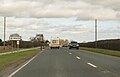 A1035 entering Routh - geograph.org.uk - 5316478.jpg 2,605 × 1,668; 1.58 MB
-
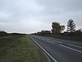
 A1035 heading north east - geograph.org.uk - 4339449.jpg 640 × 480; 63 KB
-
 A1035 heading north east - geograph.org.uk - 4339454.jpg 640 × 480; 71 KB
-
 A1035 north of Routh - geograph.org.uk - 5317506.jpg 2,710 × 1,768; 1.96 MB
-
 A1035 toward Routh - geograph.org.uk - 4988384.jpg 2,302 × 1,726; 1.36 MB
-
 A1035 towards Beverley - geograph.org.uk - 1552180.jpg 640 × 480; 40 KB
-
 A1035 towards Beverley - geograph.org.uk - 4988363.jpg 1,746 × 1,337; 911 KB
-
 A1035 towards Brandesburton - geograph.org.uk - 1552187.jpg 640 × 480; 49 KB
-
 A1035 towards Brandesburton - geograph.org.uk - 1552335.jpg 640 × 480; 80 KB
-
 All Saints Church, Meaux Lane, Routh - geograph.org.uk - 5397482.jpg 5,100 × 3,399; 6.42 MB
-
 All Saints Church, Routh - geograph.org.uk - 5197875.jpg 1,600 × 1,065; 652 KB
-
 All Saints Church, Routh - geograph.org.uk - 5197876.jpg 1,600 × 1,065; 680 KB
-
 All Saints Church, Routh - geograph.org.uk - 5197877.jpg 1,600 × 1,065; 947 KB
-
 All Saints Church, Routh - geograph.org.uk - 5197879.jpg 1,600 × 1,065; 828 KB
-
 All Saints Church, Routh - geograph.org.uk - 5197890.jpg 1,600 × 1,065; 550 KB
-
 All Saints' Church, Routh - geograph.org.uk - 2604145.jpg 743 × 927; 492 KB
-
 Beverley windfarm, aerial - geograph.org.uk - 3138885.jpg 640 × 427; 60 KB
-
 Bridlington 20, Beverley 3 (miles) - geograph.org.uk - 1222430.jpg 640 × 538; 461 KB
-
 Busy A1035 at Hall Farm - geograph.org.uk - 6388251.jpg 1,024 × 768; 195 KB
-
 Christadelphian Meeting Room, Routh - geograph.org.uk - 4340002.jpg 640 × 480; 62 KB
-
 Church Farm on Meaux Lane, Routh - geograph.org.uk - 2198581.jpg 800 × 600; 248 KB
-
 Church Farm, Routh - geograph.org.uk - 1161505.jpg 480 × 640; 133 KB
-
 Church of All Saints, Routh - geograph.org.uk - 5284167.jpg 1,024 × 768; 262 KB
-

-
 Cottage Farm, Routh - geograph.org.uk - 37755.jpg 640 × 480; 96 KB
-
 Cottages by the A1035, Routh - geograph.org.uk - 5644177.jpg 1,024 × 768; 111 KB
-
 Crop field beside woodland, Routh Carrs (geograph 4348291).jpg 640 × 480; 63 KB
-
 Crowshore Plantation, Routh - geograph.org.uk - 489882.jpg 455 × 640; 86 KB
-
 Crowshore Plantation, Routh - geograph.org.uk - 489888.jpg 480 × 640; 99 KB
-
 Crowshore Plantation, Routh - geograph.org.uk - 489894.jpg 470 × 640; 162 KB
-
 Cycle path beside the A1035 - geograph.org.uk - 4339982.jpg 640 × 480; 66 KB
-
 Cycle path beside the A1035 - geograph.org.uk - 4339993.jpg 640 × 480; 69 KB
-
 Cycle path beside the A1035 - geograph.org.uk - 4339995.jpg 640 × 480; 59 KB
-
 Cycle path beside the A1035 - geograph.org.uk - 4344118.jpg 640 × 480; 54 KB
-
 Cycle path beside the A1035 - geograph.org.uk - 4344127.jpg 640 × 480; 64 KB
-

-
 Cycle route beside the A1035 - geograph.org.uk - 4339434.jpg 640 × 480; 85 KB
-
 Cycle route beside the A1035 - geograph.org.uk - 4339435.jpg 640 × 480; 61 KB
-
 Cycle route beside the A1035 - geograph.org.uk - 4339446.jpg 640 × 480; 76 KB
-
 Disused cottage, Cottage Farm - geograph.org.uk - 4344125.jpg 640 × 480; 64 KB
-
 Disused field entrance off the A1035 - geograph.org.uk - 4339452.jpg 640 × 480; 127 KB
-
 Drain beside farm track (geograph 4348900).jpg 640 × 480; 64 KB
-
 Drain junction, North Carr (geograph 4348898).jpg 640 × 480; 88 KB
-
 Drain north of Meaux Abbey - geograph.org.uk - 722883.jpg 640 × 398; 101 KB
-
 Dual use path beside the A1035, Routh - geograph.org.uk - 6361471.jpg 5,184 × 3,888; 3.55 MB
-
 Dual use path beside the A1035, Routh - geograph.org.uk - 6361472.jpg 4,092 × 2,850; 2.09 MB
-

-
 Elizabeth II postbox on the A1035, Routh - geograph.org.uk - 6361464.jpg 4,927 × 3,582; 4.84 MB
-
 Entering Routh, A1035 - geograph.org.uk - 5358632.jpg 640 × 426; 35 KB
-

-
 Farm building, Hall Farm - geograph.org.uk - 4355220.jpg 640 × 480; 58 KB
-
 Farm buildings at Hall Farm Routh - geograph.org.uk - 4988371.jpg 1,854 × 1,345; 967 KB
-
 Farm buildings, Hall Farm - geograph.org.uk - 4339437.jpg 640 × 480; 71 KB
-
 Farm track and drain (geograph 6353443).jpg 1,024 × 768; 134 KB
-
 Farm track, North Carrs (geograph 4348896).jpg 640 × 480; 46 KB
-
 Farmland near Carr House Farm - geograph.org.uk - 1467950.jpg 640 × 480; 39 KB
-
 Farmland near High Farm Country Park - geograph.org.uk - 1552328.jpg 640 × 521; 46 KB
-
 Farmland near Routh - geograph.org.uk - 37757.jpg 640 × 480; 104 KB
-
 Farmland north of the A1035 - geograph.org.uk - 4344116.jpg 640 × 480; 51 KB
-
 Farmland, Routh - geograph.org.uk - 4355219.jpg 640 × 464; 52 KB
-
 Farmland, Routh - geograph.org.uk - 4361730.jpg 640 × 480; 40 KB
-
 Field entrance off the A1035 - geograph.org.uk - 4339988.jpg 640 × 402; 40 KB
-
 Field near Manor House Farm, Routh - geograph.org.uk - 786682.jpg 640 × 455; 190 KB
-
 Field near Meaux Lane (geograph 7110195).jpg 1,024 × 683; 321 KB
-
 Flat farmland near Tickton Grange - geograph.org.uk - 4339431.jpg 640 × 480; 72 KB
-
 Going sowing, south of Routh (geograph 7287938).jpg 1,024 × 683; 960 KB
-
 Hall Farm - geograph.org.uk - 4339436.jpg 640 × 480; 99 KB
-
 Hall Farm - geograph.org.uk - 4344115.jpg 745 × 447; 59 KB
-
 Hall Farm - geograph.org.uk - 4361733.jpg 640 × 480; 48 KB
-
 Hall Farm Routh - geograph.org.uk - 4988349.jpg 1,877 × 1,380; 1.04 MB
-
 Hall Farm, Routh - geograph.org.uk - 490075.jpg 472 × 640; 115 KB
-
 Hall Farm, Routh - geograph.org.uk - 6364147.jpg 800 × 545; 125 KB
-
 Hedgerow, High Farm Country Park - geograph.org.uk - 1552325.jpg 640 × 480; 69 KB
-
 Heron Lakes - geograph.org.uk - 6246385.jpg 1,024 × 768; 162 KB
-
 High Farm Country Park - geograph.org.uk - 488421.jpg 640 × 480; 98 KB
-
 High Farm Country Park - geograph.org.uk - 488423.jpg 454 × 640; 117 KB
-
 High Farm Country Park lake, near Routh - geograph.org.uk - 4618880.jpg 470 × 640; 439 KB
-
 High Farm Country Park, near Routh - geograph.org.uk - 253363.jpg 640 × 437; 83 KB
-
 High Farm, Routh - geograph.org.uk - 488414.jpg 483 × 640; 81 KB
-
 Holiday Camp Entrance - geograph.org.uk - 238071.jpg 640 × 480; 87 KB
-
 Holiday homes, Routh - geograph.org.uk - 4618851.jpg 640 × 462; 345 KB
-
 Houses on Park View, Routh - geograph.org.uk - 6362126.jpg 800 × 600; 90 KB
-
-

-

-
 Lake at High Farm, near Routh - geograph.org.uk - 4618877.jpg 640 × 480; 483 KB
-
 Lay-by of the A1035 - geograph.org.uk - 4339433.jpg 640 × 480; 63 KB
-
 Layby on A1035 - geograph.org.uk - 1222448.jpg 640 × 427; 361 KB
-
 Long Riston, aerial 2018 - geograph.org.uk - 5722066.jpg 800 × 533; 90 KB
-
 Looking north along track at Routh Carrs - geograph.org.uk - 3015681.jpg 2,506 × 3,508; 1 MB
-
 Main entrance to Heron Lakes from A1035 - geograph.org.uk - 4988397.jpg 2,290 × 1,710; 1.41 MB
-
 Manor House Farm - geograph.org.uk - 1552171.jpg 640 × 480; 69 KB
-
 Meaux Lane (geograph 6388258).jpg 1,024 × 664; 111 KB
-
 Meaux Lane at the bend Church Farm - geograph.org.uk - 4474568.jpg 4,608 × 3,456; 6.17 MB
-
 Meaux Lane over Routh Carrs (geograph 4474546).jpg 3,069 × 2,300; 2.31 MB
-
 Meaux Lane towards Wawne - geograph.org.uk - 2198583.jpg 800 × 600; 175 KB
-
 Minor Road Towards Meaux - geograph.org.uk - 1552178.jpg 640 × 480; 35 KB
-
 Modern day cross - geograph.org.uk - 6362125.jpg 800 × 600; 103 KB
-
 Monk Bridge, near Leven - geograph.org.uk - 1169630.jpg 640 × 501; 204 KB
-
 Monk Dike - geograph.org.uk - 1467937.jpg 640 × 480; 84 KB
-
 Monk Dike - geograph.org.uk - 1552194.jpg 640 × 480; 94 KB
-
 Monk Dike - geograph.org.uk - 170645.jpg 640 × 480; 109 KB
-
 Monk Dike - geograph.org.uk - 170655.jpg 640 × 480; 122 KB
-
 Monk Dike - geograph.org.uk - 238077.jpg 640 × 480; 101 KB
-
 Monk Dike - geograph.org.uk - 6274804.jpg 1,024 × 768; 191 KB
-
 Monk Dike - geograph.org.uk - 6362131.jpg 4,773 × 3,445; 4.11 MB
-
 Monk Dike from Monk Bridge - geograph.org.uk - 4987306.jpg 4,608 × 3,456; 6.85 MB
-
 Monk Dike public footpath - geograph.org.uk - 238075.jpg 640 × 329; 46 KB
-
 Monk Dike toward Carr House Farm - geograph.org.uk - 2648912.jpg 3,264 × 2,448; 1.75 MB
-
 Monk Dike, near Long Riston - geograph.org.uk - 1169607.jpg 426 × 640; 188 KB
-
 Monk Dike, South of Carr House Farm - geograph.org.uk - 1467943.jpg 640 × 480; 93 KB
-
 Old stump and ploughed field (geograph 5283606).jpg 1,024 × 768; 199 KB
-
 Park View, Routh - geograph.org.uk - 786283.jpg 640 × 480; 216 KB
-
 Rapeseed field near Routh - geograph.org.uk - 786711.jpg 640 × 480; 204 KB
-
 Samman Hall Routh.jpg 640 × 370; 191 KB
-
 Routh - geograph.org.uk - 191875.jpg 640 × 480; 112 KB
-
 Routh Carrs - geograph.org.uk - 1161502.jpg 640 × 480; 108 KB
-
 Routh Carrs - geograph.org.uk - 337869.jpg 640 × 480; 141 KB
-
 Routh Milestone - geograph.org.uk - 1130590.jpg 640 × 480; 145 KB
-
 Routh Parish Church - geograph.org.uk - 4474578.jpg 4,592 × 3,436; 6.85 MB
-
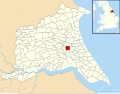 Routh, East Riding of Yorkshire UK parish locator map.svg 1,425 × 1,107; 1.68 MB
-
 Routh, East Yorkshire - geograph.org.uk - 2166565.jpg 800 × 600; 252 KB
-
 Side entrance to Church Farm - geograph.org.uk - 6388255.jpg 1,024 × 768; 189 KB
-
 Sign for the Nags Head, Routh - geograph.org.uk - 4339443.jpg 480 × 640; 68 KB
-
 Sign for the Nags Head, Routh - geograph.org.uk - 6362128.jpg 484 × 800; 74 KB
-
 Stubble field, Tickton - geograph.org.uk - 6362124.jpg 800 × 600; 102 KB
-
 The A1035 - geograph.org.uk - 238074.jpg 640 × 480; 88 KB
-
 The A1035 at Routh - geograph.org.uk - 238070.jpg 640 × 412; 69 KB
-
 The churchyard, Routh - geograph.org.uk - 5283607.jpg 1,024 × 768; 200 KB
-
 The Heron Lakes Lodge Park near Routh - geograph.org.uk - 2206140.jpg 800 × 600; 205 KB
-
 The Nag's Head, Routh - geograph.org.uk - 1222457.jpg 640 × 427; 359 KB
-
 The Nag's Head, Routh - geograph.org.uk - 5316491.jpg 2,456 × 1,730; 2.78 MB
-
 The Nags Head near Routh - geograph.org.uk - 590792.jpg 640 × 480; 84 KB
-
 The Nags Head, Routh - geograph.org.uk - 4339441.jpg 640 × 480; 69 KB
-
 The Nags Head, Routh - geograph.org.uk - 5358633.jpg 640 × 425; 64 KB
-

-
 Tickton Bridge - geograph.org.uk - 490085.jpg 640 × 475; 105 KB
-
 Tickton Carrs - geograph.org.uk - 490421.jpg 640 × 442; 87 KB
-
 Tickton Milestone - geograph.org.uk - 1130589.jpg 640 × 480; 99 KB
-
 Tickton Pumping Station - geograph.org.uk - 827533.jpg 640 × 427; 96 KB
-

-
 View towards Routh Carrs (geograph 5284170).jpg 1,024 × 768; 108 KB
-
 View towards the wind farm near Eske - geograph.org.uk - 5287194.jpg 1,024 × 768; 108 KB
-
 Water lilies at High Farm Country Park - geograph.org.uk - 4618860.jpg 516 × 640; 258 KB
-
 Wind turbine - geograph.org.uk - 4804745.jpg 2,736 × 3,648; 2.11 MB
-
 Woodland flat field and Manor House Farm - geograph.org.uk - 4474557.jpg 4,600 × 3,446; 6.81 MB
-
 WWI Memorial ^ Roll of Honour Plaque - geograph.org.uk - 5197881.jpg 1,600 × 1,065; 811 KB
.jpg)


_-_geograph.org.uk_-_1222430.jpg)


.jpg)


.jpg)
.jpg)


_-_geograph.org.uk_-_1552185.jpg)


.jpg)
.jpg)


.jpg)

.jpg)


.jpg)

.jpg)


.jpg)


_-_geograph.org.uk_-_323977.jpg)


.jpg)


