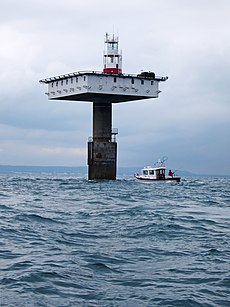
Category:Royal Sovereign Lighthouse
Jump to navigation
Jump to search
| Object location | | View all coordinates using: OpenStreetMap |
|---|
lighthouse | |||||
| Upload media | |||||
| Instance of |
| ||||
|---|---|---|---|---|---|
| Location | Eastbourne, East Sussex, South East England, England | ||||
| Operator | |||||
| Service entry |
| ||||
| Inception |
| ||||
| Significant event |
| ||||
| Height |
| ||||
| Replaces |
| ||||
 | |||||
Media in category "Royal Sovereign Lighthouse"
The following 16 files are in this category, out of 16 total.
-
A distant Royal Sovereign lighthouse - geograph.org.uk - 4551932.jpg 1,024 × 768; 144 KB
-
Admiralty Chart No 536 Beachy Head to Dungeness, Published 1967.jpg 16,414 × 11,300; 31.73 MB
-
Light tower - geograph.org.uk - 4647009.jpg 3,924 × 2,616; 2.79 MB
-
Light tower - geograph.org.uk - 4647058.jpg 4,000 × 3,000; 2.4 MB
-
Light tower - geograph.org.uk - 4647062.jpg 2,908 × 3,877; 2.68 MB
-
Light tower - geograph.org.uk - 4647089.jpg 2,867 × 3,822; 2.66 MB
-
Light tower - geograph.org.uk - 4647091.jpg 3,000 × 4,000; 2.61 MB
-
Light tower - geograph.org.uk - 4647092.jpg 3,000 × 4,000; 2.57 MB
-
Royal Sovereign light tower (3231440865).jpg 3,462 × 2,580; 786 KB
-
Royal Sovereign light tower (geograph 4647003).jpg 3,000 × 4,000; 2.73 MB
-
Royal Sovereign light tower (geograph 4647055).jpg 2,943 × 3,924; 3.01 MB
-
Royal Sovereign light tower (geograph 4647090).jpg 3,000 × 4,000; 2.29 MB
-
Royal Sovereign Lighthouse.jpg 4,047 × 3,035; 860 KB


