Category:Ruiterberg (Doorn)
Jump to navigation
Jump to search
| Object location | | View all coordinates using: OpenStreetMap |
|---|
hill in the Netherlands | |||||
| Upload media | |||||
| Instance of | |||||
|---|---|---|---|---|---|
| Location | Doorn, Utrecht, Netherlands | ||||
| Elevation above sea level |
| ||||
 | |||||
|
This is a category about rijksmonumentcomplex number 513946
|
Poortgebouw
|
This is a category about rijksmonument number 513945
|
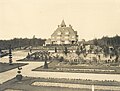
Historische aanleg
|
This is a category about rijksmonument number 513947
|
Jachthuis
|
This is a category about rijksmonument number 513948
|
IJskelder
|
This is a category about rijksmonument number 513949
|
| Address |
|
Media in category "Ruiterberg (Doorn)"
The following 28 files are in this category, out of 28 total.
-
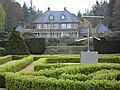 Doorn - Landhuis Ruiterberg.JPG 4,608 × 3,456; 2.21 MB
-
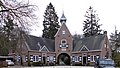 Doorn - Poortgebouw De Ruiterberg, Maarsbergseweg 2 RM513945.JPG 4,305 × 2,430; 1.29 MB
-
 Doorn - Ruiterberg Jachthuis RM513948.JPG 2,450 × 2,450; 900 KB
-
 Doorn - Ruiterberg, Park RM513947.JPG 4,608 × 3,456; 4.29 MB
-
 Landhuis oud Ruiterberg.jpg 4,728 × 3,579; 4.35 MB
-
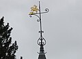 Ruiter windvaan.jpg 1,871 × 1,356; 420 KB
-
 Ruiterberg bos.jpg 3,264 × 2,448; 4.24 MB
-
 Ruiterberg hekwerk.jpg 3,264 × 2,448; 3.59 MB
-
 Ruiterberg poort.jpg 3,264 × 2,448; 3.01 MB
-
 Ruiterberg siertuin.jpg 3,264 × 2,448; 2.16 MB
-
 Ruiterberg steen.jpg 2,682 × 1,896; 1.19 MB
-
 Ruiterberg uitzicht top.jpg 3,264 × 2,448; 3.41 MB
-
 Ruiterberg, Doornse Gat, Maasbergseweg, De Kaap, Sint Helenalaan 11 46 22 516000.jpeg 4,032 × 3,024; 2.18 MB
-
 Ruiterberg, Doornse Gat, Maasbergseweg, De Kaap, Sint Helenalaan 11 46 29 961000.jpeg 4,032 × 3,024; 4.13 MB
-
 Ruiterberg, Doornse Gat, Maasbergseweg, De Kaap, Sint Helenalaan 11 46 40 204000.jpeg 4,032 × 3,024; 5.21 MB
-
 Ruiterberg, Doornse Gat, Maasbergseweg, De Kaap, Sint Helenalaan 11 52 08 031000.jpeg 4,032 × 3,024; 5.06 MB
-
 Ruiterberg, Doornse Gat, Maasbergseweg, De Kaap, Sint Helenalaan 11 52 19 559000.jpeg 4,032 × 3,024; 3.86 MB
-
 Ruiterberg, Doornse Gat, Maasbergseweg, De Kaap, Sint Helenalaan 11 52 30 191000.jpeg 4,032 × 3,024; 5.13 MB
-
 Ruiterberg, Doornse Gat, Maasbergseweg, De Kaap, Sint Helenalaan 11 52 44 133000.jpeg 4,032 × 3,024; 4.83 MB
-
 Ruiterberg, Doornse Gat, Maasbergseweg, De Kaap, Sint Helenalaan 11 52 57 843000.jpeg 4,032 × 3,024; 2.63 MB
-
 Ruiterberg, Doornse Gat, Maasbergseweg, De Kaap, Sint Helenalaan 11 53 03 682000.jpeg 4,032 × 3,024; 2.35 MB
-
 Ruiterberg, Doornse Gat, Maasbergseweg, De Kaap, Sint Helenalaan 11 53 11 070000.jpeg 4,032 × 3,024; 1.87 MB
-
 Ruiterberg, Doornse Gat, Maasbergseweg, De Kaap, Sint Helenalaan 11 53 16 186000.jpeg 4,032 × 3,024; 2.07 MB
-
 Ruiterberg, Doornse Gat, Maasbergseweg, De Kaap, Sint Helenalaan 11 53 21 721000.jpeg 4,032 × 3,024; 5.94 MB
-
 Ruiterberg, Doornse Gat, Maasbergseweg, De Kaap, Sint Helenalaan 11 53 34 927000.jpeg 3,024 × 4,032; 4.54 MB
-
 Ruiterberg, Doornse Gat, Maasbergseweg, De Kaap, Sint Helenalaan 11 53 43 425000.jpeg 4,032 × 3,024; 5.69 MB
-
 Ruiterberg, Doornse Gat, Maasbergseweg, De Kaap, Sint Helenalaan 11 53 53 684000.jpeg 4,032 × 3,024; 2.95 MB
-
 Ruiterberg, Doornse Gat, Maasbergseweg, De Kaap, Sint Helenalaan.jpeg 4,032 × 3,024; 4.65 MB


