Category:SVG locator maps of districts of Uttarakhand (location map scheme)
Jump to navigation
Jump to search
Media in category "SVG locator maps of districts of Uttarakhand (location map scheme)"
The following 13 files are in this category, out of 13 total.
-
 Almora in Uttarakhand (India).svg 957 × 795; 643 KB
-
 Bageshwar in Uttarakhand (India).svg 957 × 795; 643 KB
-
 Chamoli in Uttarakhand (India).svg 957 × 795; 643 KB
-
 Champawat in Uttarakhand (India).svg 957 × 795; 643 KB
-
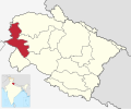 Dehradun in Uttarakhand (India).svg 957 × 795; 643 KB
-
 Haridwar in Uttarakhand (India).svg 957 × 795; 643 KB
-
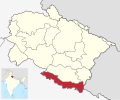
 Nainital in Uttarakhand (India).svg 957 × 795; 643 KB
-
 Pauri Garhwal in Uttarakhand (India).svg 957 × 795; 643 KB
-
 Pithoragarh in Uttarakhand (India).svg 957 × 795; 643 KB
-
 Rudraprayag in Uttarakhand (India).svg 957 × 795; 643 KB
-
 Tehri Garhwal in Uttarakhand (India).svg 957 × 795; 643 KB
-
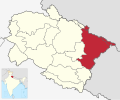
 Udham Singh Nagar in Uttarakhand (India).svg 957 × 795; 643 KB
-
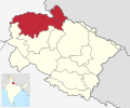 Uttarkashi in Uttarakhand (India).svg 957 × 795; 643 KB
.svg)
.svg)
.svg)
.svg)
.svg)
.svg)
.svg)
.svg)
.svg)
.svg)
.svg)
.svg)
.svg)