Category:SVG maps of counties of South Sudan
Jump to navigation
Jump to search
Media in category "SVG maps of counties of South Sudan"
The following 12 files are in this category, out of 12 total.
-
 Central Equatoria State Counties.svg 207 × 240; 57 KB
-
 Eastern Equatoria State Counties.svg 362 × 217; 71 KB
-
 Jonglei State Counties.svg 287 × 316; 60 KB
-
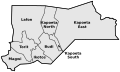
 Lakes States Counties.svg 279 × 188; 64 KB
-
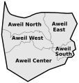 Northern Bahr el Ghazal Counties.svg 167 × 175; 46 KB
-
 Pibor Administrative Area Counties.svg 229 × 177; 49 KB
-
 Ruweng Administrative Area Counties.svg 182 × 90; 24 KB
-
 Unity State Counties.svg 176 × 233; 43 KB
-
 Upper Nile State Counties.svg 303 × 367; 120 KB
-
 Warrap Counties.svg 161 × 256; 50 KB
-
 Western Bahr el Ghazal Counties.svg 482 × 326; 90 KB
-
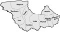 Western Equatoria State Counties.svg 404 × 219; 96 KB


