Category:SVG maps of historic counties of England in Sect 5
Jump to navigation
Jump to search
Media in category "SVG maps of historic counties of England in Sect 5"
The following 33 files are in this category, out of 33 total.
-
 Bedfordshire Brit Isles Sect 5.svg 809 × 743; 939 KB
-
 Berkshire Brit Isles Sect 5.svg 809 × 743; 939 KB
-
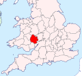
 Buckinghamshire Brit Isles Sect 5.svg 809 × 743; 939 KB
-
 Cambridgeshire Brit Isles Sect 5.svg 809 × 743; 939 KB
-
 Cheshire Brit Isles Sect 5.svg 809 × 743; 939 KB
-
 Cornwall Brit Isles Sect 5.svg 809 × 743; 939 KB
-
 Derbyshire Brit Isles Sect 5.svg 809 × 743; 939 KB
-
 Devon Brit Isles Sect 5.svg 809 × 743; 939 KB
-
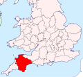
 Dorset Brit Isles Sect 5.svg 809 × 743; 939 KB
-
 Essex Brit Isles Sect 5.svg 809 × 743; 939 KB
-
 Gloucestershire Brit Isles Sect 5.svg 809 × 743; 939 KB
-
 Hampshire Brit Isles Sect 5.svg 809 × 743; 939 KB
-
 Herefordshire Brit Isles Sect 5.svg 809 × 743; 939 KB
-
 Hertfordshire Brit Isles Sect 5.svg 809 × 743; 939 KB
-
 Huntingdonshire Brit Isles Sect 5.svg 809 × 743; 939 KB
-
 Kent Brit Isles Sect 5.svg 809 × 743; 939 KB
-
 Leicestershire Brit Isles Sect 5.svg 809 × 743; 939 KB
-
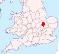
 Lincolnshire Brit Isles Sect 5.svg 809 × 743; 939 KB
-
 Middlesex Brit Isles Sect 5.svg 809 × 743; 939 KB
-
 Norfolk Brit Isles Sect 5.svg 809 × 743; 939 KB
-
 Northamptonshire Brit Isles Sect 5.svg 809 × 743; 939 KB
-
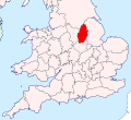 Nottinghamshire Brit Isles Sect 5.svg 809 × 743; 939 KB
-
 Oxfordshire Brit Isles Sect 5.svg 809 × 743; 939 KB
-
 Rutland Brit Isles Sect 5.svg 809 × 743; 939 KB
-
 Shropshire Brit Isles Sect 5.svg 809 × 743; 939 KB
-
 Somerset Brit Isles Sect 5.svg 809 × 743; 939 KB
-
 Staffordshire Brit Isles Sect 5.svg 809 × 743; 939 KB
-
 Suffolk Brit Isles Sect 5.svg 809 × 743; 939 KB
-
 Surrey Brit Isles Sect 5.svg 809 × 743; 939 KB
-
 Sussex Brit Isles Sect 5.svg 809 × 743; 939 KB
-
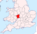
 Warwickshire Brit Isles Sect 5.svg 809 × 743; 939 KB
-
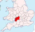
 Wiltshire Brit Isles Sect 5.svg 809 × 743; 939 KB
-
 Worcestershire Brit Isles Sect 5.svg 809 × 743; 939 KB


