Category:SVG maps of regions of Colombia
Jump to navigation
Jump to search
Media in category "SVG maps of regions of Colombia"
The following 18 files are in this category, out of 18 total.
-
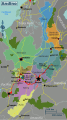 Andino regions map.svg 493 × 882; 7.04 MB
-
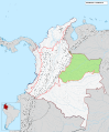
 Colombia regions map.svg 460 × 559; 1.59 MB
-
 Colombian Amazonia regions map.svg 970 × 793; 4.41 MB
-
 Colombian Islands regions map.svg 650 × 1,293; 1.15 MB
-
 Costa Norte regions map.svg 587 × 530; 5.84 MB
-
 División Subdepartamental de Colombia.svg 512 × 607; 3.02 MB
-
 Mapa de Colombia (corporaciones autónomas regionales).svg 1,420 × 1,896; 1.08 MB
-
 Mapa de Colombia (provincias).svg 1,420 × 1,896; 2.79 MB
-
 Mapa de Colombia (regiones naturales)-nn.svg 1,763 × 2,126; 1.48 MB
-
 Mapa de Colombia (regiones naturales).svg 1,763 × 2,126; 2.59 MB
-
 Mapa de Colombia (región Amazónica).svg 1,763 × 2,126; 1.45 MB
-
 Mapa de Colombia (región Andina).svg 1,763 × 2,126; 1.45 MB
-
 Mapa de Colombia (región de la Orinoquía).svg 1,763 × 2,126; 1.45 MB
-
 Mapa de Colombia (región del Caribe).svg 1,763 × 2,126; 1.45 MB
-
 Mapa de Colombia (región del Pacífico).svg 1,763 × 2,126; 1.46 MB
-
 Mapa de Colombia (región Insular).svg 1,763 × 2,126; 1.5 MB
-
 Orinoquía regions map.svg 701 × 526; 3.17 MB
-
 Pacifica regions map.svg 340 × 788; 4.31 MB


.svg)
.svg)
-nn.svg)
.svg)
.svg)
.svg)
.svg)
.svg)
.svg)
.svg)

