Category:SVG maps of the Pacific Ocean
Jump to navigation
Jump to search
Media in category "SVG maps of the Pacific Ocean"
The following 26 files are in this category, out of 26 total.
-
 52 hz whale map.svg 240 × 180; 209 KB
-
 Barge T-36 drift and rescue - en.svg 1,770 × 925; 218 KB
-
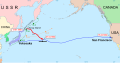
 Barge T-36 drift and rescue - ru.svg 1,770 × 925; 232 KB
-
 Barge T-36 drift and rescue 2 - ru.svg 1,207 × 1,235; 444 KB
-
 Cypron-Range Eschrichtius robustus.svg 863 × 443; 1.2 MB
-

-
 Dragon's triangle ufo files.svg 480 × 640; 1.68 MB
-
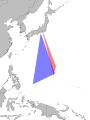
 Dragon's Triangle.svg 744 × 1,052; 244 KB
-
 ICJ Peru Chile judgment map4 (svg version).svg 3,036 × 2,176; 2.19 MB
-
 Manoumi.svg 240 × 320; 299 KB
-
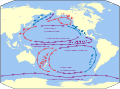
 Map of the Pacific region (currents).svg 730 × 543; 359 KB
-
 Map of the Pacific region сurrents be.svg 730 × 543; 355 KB
-
 Map of the Pacific region.svg 730 × 543; 298 KB
-

-
 Mapa del Mar de Balboa (límites marinos).svg 2,177 × 2,006; 530 KB
-
 Maritime boundaries between UK and France in Pacific Ocean-fr.svg 2,934 × 1,584; 750 KB
-
-
 Oceania full blank map.svg 4,376 × 3,070; 777 KB
-
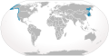
 Pacific Ocean laea location map.svg 709 × 645; 217 KB
-
 Pacific Rim map (Miller cylindrical projection, blank).svg 415 × 330; 2.1 MB
-
 Planisphère océan pacifique.svg 3,040 × 1,396; 346 KB
-
 Saavedra-1527-1529-es.svg 728 × 389; 451 KB
-
 Saavedra-1527-1529.svg 728 × 389; 267 KB
-
 Ukraine Security Cooperation Agreements Pacific.svg 335 × 170; 263 KB
-
 WGSRPD Pacific.svg 709 × 641; 262 KB
-
 World2Hires filled mercator.svg 220 × 171; 11.45 MB


.svg)

.svg)


_in_the_Australia-New_Zealand_region_of_the_South_Pacific.svg)
.svg)


.svg)