Category:SVG maps of the history of Lithuania
Jump to navigation
Jump to search

Subcategories
This category has only the following subcategory.
P
Media in category "SVG maps of the history of Lithuania"
The following 29 files are in this category, out of 29 total.
-

-
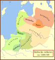 Balten 1200.svg 1,003 × 1,096; 338 KB
-
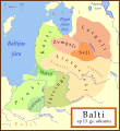 Balti ap 13.gs.svg 1,003 × 1,096; 530 KB
-
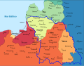
 Baltic states territorial changes 1939-45 en.svg 1,198 × 1,302; 411 KB
-
 Baltic states territorial changes 1939-45 es.svg 1,198 × 1,302; 411 KB
-
 Baltic Tribes c 1200 es.svg 988 × 1,088; 650 KB
-
 Baltic Tribes c 1200 pt.svg 988 × 1,088; 278 KB
-
 Baltic Tribes c 1200-hu.svg 768 × 850; 382 KB
-
 Baltic Tribes c 1200-uk.svg 988 × 1,088; 375 KB
-
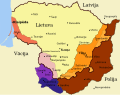
 Baltic Tribes c 1200PL..svg 550 × 599; 186 KB
-
 Baltic Tribes circa 1200 ad.png 550 × 599; 126 KB
-
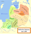 Baltische Stämme um 1200.svg 988 × 1,088; 447 KB
-
 Baltų gentys 12-as amžius.svg 1,003 × 1,096; 650 KB
-
 Baltų gentys XII amžiuje.svg 1,003 × 1,096; 642 KB
-
 Grand Duchy of Lithuania 1462 within modern boundaries-en.svg 1,152 × 1,028; 792 KB
-
 Lietuva 1921-1939.svg 2,078 × 1,689; 109 KB
-
 Lietuvas teritorija no 1939. līdz 1940. gadam.svg 2,479 × 1,954; 208 KB
-
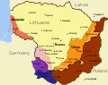
 Lithuania territory 1939-1940 de.svg 2,479 × 1,954; 108 KB
-
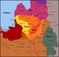
 Lithuania territory 1939-1940-es.svg 2,479 × 1,954; 207 KB
-
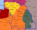
 Lithuania territory 1939-1940-hu.svg 2,479 × 1,954; 210 KB
-
 Lithuania territory 1939-1940.svg 2,479 × 1,954; 211 KB
-
 LSSR-1919.svg 4,323 × 4,157; 277 KB
-
 Map of Litbel 1919-es.svg 5,416 × 4,237; 260 KB
-
 Map of Litbel 1919-hu.svg 4,100 × 3,300; 311 KB
-
 Map of Litbel 1919.svg 4,100 × 3,300; 328 KB
-
 Mapa Lit-Biełu 1919.svg 4,100 × 3,300; 328 KB
-
 Russo–Lithuanian Wars-1500 campaign ro.svg 578 × 627; 196 KB
-
 Terytorium Litwy 1939-1940.svg 2,482 × 1,958; 168 KB
-
 Карта территориальных споров и претензий относительно Литвы в 1939-1940 гг.svg 2,479 × 1,954; 168 KB


