Category:SVG topographic maps of Mauritius
Jump to navigation
Jump to search
Media in category "SVG topographic maps of Mauritius"
The following 15 files are in this category, out of 15 total.
-
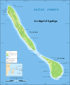
 Agalega Islands map-en.svg 1,500 × 1,825; 434 KB
-
 Agalega Islands map-fr.svg 1,500 × 1,825; 434 KB
-
 Agalega Islands map-mk.svg 1,500 × 1,825; 431 KB
-
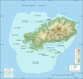 Rodrigues Island topographic map-de.svg 1,700 × 1,600; 750 KB
-
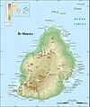
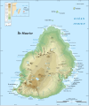
 Mauritius Island topographic map-be.svg 1,810 × 2,160; 1.92 MB
-
 Mauritius Island topographic map-de.svg 1,810 × 2,160; 1.93 MB
-
 Mauritius Island topographic map-fr.jpg 1,810 × 2,160; 942 KB
-
 Mauritius Island topographic map-fr.svg 1,810 × 2,160; 1.93 MB
-
 Rodrigues Island bathymetric environment map-fr.svg 1,776 × 1,173; 1.02 MB
-
 Rodrigues Island bathymetric environment map-mk.svg 1,776 × 1,173; 1.02 MB
-
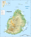
 Rodrigues Island relief map.svg 1,700 × 1,600; 697 KB
-
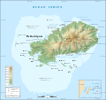
 Rodrigues Island topographic map-be.svg 1,700 × 1,600; 971 KB
-
 Rodrigues Island topographic map-fr.svg 1,700 × 1,600; 1,001 KB
-
 Rodrigues Island topographic map-rus.svg 1,700 × 1,600; 1,016 KB
-
 Rodrigues Island topographic-zones map-fr.svg 1,700 × 1,600; 989 KB


