Category:Saint Andrew church, Dolná Krupá
Jump to navigation
Jump to search
| Object location | | View all coordinates using: OpenStreetMap |
|---|
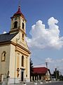
| This category shows the protected monument with the number 207-806/0 (other) in the Slovak Republic. |
Slovenčina: Rímskokatolícky kostol sv. Ondreja, Dolná Krupá, okres Trnava
Media in category "Saint Andrew church, Dolná Krupá"
The following 6 files are in this category, out of 6 total.
-
 Dolna krupa 01.jpg 983 × 768; 166 KB
-
 Dolna krupa 02.jpg 994 × 768; 154 KB
-
 Dolna krupa 03.jpg 509 × 768; 75 KB
-
 Dolná Krupá - Kostol svätého Ondreja.jpg 3,024 × 4,032; 2.68 MB
-
 Dolná Krupá - misijný kríž na kostole.jpg 3,024 × 4,032; 3.23 MB
-
 Kostol sv.Ondreja - Dolna Krupa.jpg 576 × 768; 75 KB


