Category:Saint Lawrence River
Jump to navigation
Jump to search
major river in eastern Canada and the United States, flowing into the Gulf of St. Lawrence   | |||||
| Upload media | |||||
| Instance of | |||||
|---|---|---|---|---|---|
| Named after | |||||
| Location | |||||
| Has part(s) |
| ||||
| Heritage designation |
| ||||
| Length |
| ||||
| Elevation above sea level |
| ||||
| Origin of the watercourse |
| ||||
| Mouth of the watercourse | |||||
| Drainage basin | |||||
| Basin country | |||||
| Tributary |
| ||||
| Lake on watercourse |
| ||||
 | |||||
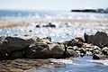
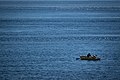
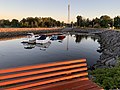
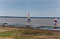
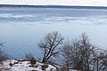
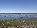
English: Saint Lawrence River is a large river flowing approximately from southwest to northeast in the middle latitudes of North America, connecting the Great Lakes with the Atlantic Ocean
Français : Le Saint-Laurent est un fleuve qui relie les Grands Lacs de l’Amérique du Nord à l’océan Atlantique.
Subcategories
This category has the following 33 subcategories, out of 33 total.
A
- Saint Lawrence River in art (68 F)
B
C
F
I
K
- Quais de Kamouraska (2 F)
L
- Le Grand Rassemblement (16 F)
M
P
- Le Petit Pouvoir (4 F)
R
S
- Saint Lawrence River in Oka (3 F)
- St. Lawrence Reservation (7 F)
- Sunken Rock Light (6 F)
T
W
Pages in category "Saint Lawrence River"
This category contains only the following page.
Media in category "Saint Lawrence River"
The following 200 files are in this category, out of 543 total.
(previous page) (next page)-
 000730 15a 3545 2367 fleuve I Orleans.jpg 3,545 × 2,367; 8.74 MB
-
 000730 15aa.jpg 3,550 × 2,373; 8.78 MB
-
 000730 19aa.jpg 2,364 × 3,559; 8.11 MB
-
 011 066 Iles Mingan.jpg 4,128 × 2,719; 6.25 MB
-
 011 078 Iles Mingan.jpg 4,106 × 2,709; 3.41 MB
-
 011 098 Iles Mingan.jpg 4,095 × 2,709; 4.2 MB
-
 011 102 Iles Mingan.jpg 2,720 × 4,106; 4.1 MB
-
 011 138 Niapiskau.jpg 2,762 × 4,095; 4.08 MB
-
 012 005 Iles Mingan.jpg 4,127 × 2,719; 4.31 MB
-
 012 028 Ile Mingan Niapiskau.jpg 2,719 × 4,085; 4.15 MB
-
 012 031 Ile Mingan Niapiscau.jpg 2,720 × 4,042; 4.2 MB
-
 012 035 Ile Mingan Niapiscau.jpg 2,698 × 4,149; 3.98 MB
-
 012 043 Iles Mingan Niapiscau.jpg 2,698 × 4,117; 4.66 MB
-
 012 049 Iles Mingan Niapiscau flore.jpg 4,106 × 2,720; 7.59 MB
-
 012 053 Iles Mingan Niapiscau.jpg 2,720 × 4,095; 7.3 MB
-
 012 060 ile Mingan.jpg 4,095 × 2,719; 5.62 MB
-
 012 104 Iles Mingan.jpg 4,042 × 2,570; 3.31 MB
-
 012 120 Iles Mingan.jpg 4,085 × 2,720; 4.31 MB
-
 012 125 Iles Mingan.jpg 4,117 × 2,570; 6.13 MB
-
 012 133 Iles Mingan.jpg 4,127 × 2,570; 3.47 MB
-
 012 137 Havre St Pierre.jpg 4,117 × 2,709; 3.89 MB
-
 013 011 Havre St Pierre.jpg 4,106 × 2,720; 4.2 MB
-
 013 012 Havre St Pierre.jpg 4,106 × 2,719; 3.3 MB
-
 013 014 Havre St Pierre.jpg 4,095 × 2,730; 3.35 MB
-
 013 016 Havre St Pierre.jpg 4,095 × 2,709; 4.57 MB
-
 013 017 Havre St Pierre.jpg 4,117 × 2,720; 4.83 MB
-
 013 021 Havre St Pierre.jpg 4,095 × 2,709; 4.15 MB
-
 013 080 Isle aux Coudres a.jpg 4,138 × 2,741; 4.91 MB
-
 013 080 Isle aux Coudres.jpg 4,319 × 3,022; 5.12 MB
-
 013 081 Isle aux Coudres.jpg 4,212 × 2,875; 5.03 MB
-
 013 084 Isle aux Coudres.jpg 2,570 × 4,138; 3.24 MB
-
 013 090 Isle aux Coudres.jpg 4,117 × 2,570; 4.39 MB
-
 013 092 Isle aux Coudres.jpg 4,117 × 2,730; 4.74 MB
-
 013 093 Isle aux Coudres.jpg 4,085 × 2,752; 4.09 MB
-
 013 094 Isle aux Coudres.jpg 2,730 × 4,117; 4.12 MB
-
 013 099 Isle aux Coudres.jpg 4,085 × 2,720; 3.9 MB
-
 013 101 Isle aux Coudres.jpg 4,149 × 2,794; 4.18 MB
-
 100 2993.JPG 2,080 × 1,544; 1.01 MB
-
 172 7202.jpg 1,024 × 768; 202 KB
-
 18 of '(The St. Lawrence Pilot ... Fourth edition.)' (11153330153).jpg 2,704 × 1,681; 959 KB
-
-
 20020613 19a Saint Jean Port Joli.jpg 3,564 × 2,372; 3.86 MB
-
 20020614 25 Ile Vertea.jpg 3,567 × 2,360; 6.54 MB
-
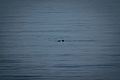 2016-08 Grandes Bergeronnes Saint Lawrence River Harbour porpoise.jpg 5,459 × 3,639; 7.49 MB
-
 2016-08 Kayak Grandes Bergeronnes Saint Lawrence River 01.jpg 6,000 × 4,000; 7.71 MB
-
 2016-08 Kayak Grandes Bergeronnes Saint Lawrence River 02.jpg 5,403 × 3,045; 6.32 MB
-
 2016-08 Kayak Grandes Bergeronnes Saint Lawrence River 03.jpg 5,574 × 3,716; 9.17 MB
-
 2016-08 Tadoussac 02.jpg 5,677 × 3,785; 12.77 MB
-
 2016-08 Tadoussac 06.jpg 6,000 × 4,000; 10.55 MB
-
 2016-08 Tadoussac 10.jpg 5,785 × 3,857; 16.47 MB
-
 2016-08 Tadoussac 11.jpg 6,000 × 4,000; 11.38 MB
-
 2016-08 Tadoussac 12.jpg 5,209 × 3,473; 10.69 MB
-
 2016-08 Tadoussac 13.jpg 5,860 × 3,907; 10.24 MB
-
 2016-08 Tadoussac 14.jpg 6,000 × 4,000; 9.54 MB
-
 2016-08 Tadoussac 15.jpg 5,889 × 3,926; 12.51 MB
-
 2016-08 Tadoussac 16.jpg 6,000 × 4,000; 19.82 MB
-
 2016-08 Tadoussac 17.jpg 5,304 × 3,536; 9.28 MB
-
 2016-08 Tadoussac 18.jpg 5,868 × 3,912; 11.05 MB
-
 2016-08 Tadoussac 20.jpg 5,904 × 3,936; 8.68 MB
-
 2016-08 Tadoussac 21.jpg 6,000 × 4,000; 10.84 MB
-
 2016-08 Tadoussac 24.jpg 5,737 × 2,537; 7.37 MB
-
 2020 02 01 027 Grondines.jpg 4,032 × 3,024; 2.93 MB
-
 2020 08 14 046 quai Grondines.jpg 4,032 × 3,024; 2.96 MB
-
 2020 09 13 001 Panneau.jpg 4,032 × 3,024; 3.9 MB
-
 2020-09-28 003 Batiscan.jpg 4,032 × 3,024; 5.43 MB
-
 950703 24a Baie au Caplan.jpg 3,567 × 2,362; 7.13 MB
-
 950715 E 3545 2324 Pointe Lac.jpg 3,545 × 2,324; 8.86 MB
-
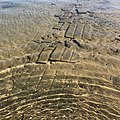 A concrete walkway under the water of the St. Lawrence River.jpg 3,024 × 3,024; 3.14 MB
-
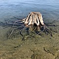 A tree stump under water in the St. Lawrence River.jpg 3,024 × 3,024; 2.47 MB
-
 Alexandria bay saint lawrence 05.07.2012 21-18-32.jpg 4,672 × 3,104; 7.87 MB
-
 Alexandria bay saint lawrence castle 05.07.2012.jpg 3,052 × 2,028; 3.37 MB
-
 Alexandria bay saint lawrence ship and flag 5.07.2012.jpg 3,215 × 2,136; 3.17 MB
-
 Alexandria bay saint lawrence uncle sam 05.07.2012.jpg 4,207 × 2,795; 7.34 MB
-
 Aluminerie Alouette 1.jpg 800 × 600; 38 KB
-
 Anse a Caron 050.jpg 5,184 × 3,456; 7.54 MB
-
 Auberge De La Pointe.jpeg 3,264 × 2,448; 2.12 MB
-
 Ausblick auf den Fluss.jpg 3,264 × 2,448; 1.34 MB
-
 Autoportrait, mon ombre sur le rivage.jpg 4,032 × 3,024; 4.66 MB
-
 Baie Comeau 1962 09 02.jpg 3,054 × 2,266; 3.51 MB
-
 Baie Trinite 009.jpg 1,600 × 1,200; 684 KB
-
 Baie Trinite 029.jpg 1,536 × 2,048; 1.74 MB
-
 Baie Trinite 031.jpg 2,048 × 1,536; 944 KB
-
 Baie Trinite 034.jpg 1,536 × 2,048; 1.16 MB
-
 Baie Trinite 037.jpg 1,536 × 2,048; 1.26 MB
-
 Baie à l'embouchure de Rivière Noire- St-Siméon-2018-07-23.jpg 4,032 × 3,024; 6.05 MB
-
 Barge transport of Gresham through St. Lawrence locks.jpg 1,500 × 716; 161 KB
-
 Bas-Saint-Laurent 1.JPG 2,080 × 1,544; 1,013 KB
-
 Bataille du Saint-Laurent2 couleur.jpg 1,076 × 902; 379 KB
-
 Batiscan 0002.jpg 4,032 × 3,024; 3.31 MB
-
 Batiscan 0005.jpg 4,032 × 3,024; 3.49 MB
-
 BATISCAN 07-2008.jpg 2,560 × 1,920; 1.73 MB
-
 Batiscan 2020 03 06 009.jpg 3,024 × 4,032; 3.64 MB
-
 Batiscan sur le Chemin du Roy 001.jpg 3,536 × 1,792; 5.51 MB
-
 Bay Street Dock (I0015079).jpg 2,487 × 1,969; 3.42 MB
-
 Beauharnois-Boul-Melocheville-SaintLaurent-20230802 175047596.jpg 4,032 × 3,024; 2.7 MB
-
 Beauharnois-Boul-Melocheville-SaintLaurent-20230802 175053910.jpg 4,032 × 3,024; 2.25 MB
-
 Beauharnois-Boul-Melocheville-SaintLaurent-20230802 175333593.jpg 4,032 × 3,024; 2.28 MB
-
 Belvedere la cime cap tourmente.JPG 5,046 × 3,365; 11.43 MB
-
 Berge du fleuve - Cap tourmente - mai 2007.jpg 2,032 × 1,524; 1.39 MB
-
 Berges au nord-est de La Malbaie 01.jpg 6,016 × 4,000; 7.27 MB
-
 Berges au nord-est de La Malbaie 02.jpg 6,016 × 4,000; 6.43 MB
-
 Berges au nord-est de La Malbaie 03.jpg 6,016 × 4,000; 6.56 MB
-
 Berges au nord-est de La Malbaie 04.jpg 6,016 × 4,000; 6.51 MB
-
 Berges au nord-est de La Malbaie 05.jpg 6,016 × 4,000; 6.93 MB
-
 Berges au nord-est de La Malbaie 06.jpg 6,016 × 4,000; 6.11 MB
-
 Berges au nord-est de La Malbaie 07.jpg 6,016 × 4,000; 6.46 MB
-
 Berges au nord-est de La Malbaie 08.jpg 4,000 × 6,016; 6.4 MB
-
 Berges au nord-est de La Malbaie 09.jpg 6,016 × 4,000; 6.47 MB
-
 Berges au nord-est de La Malbaie 10.jpg 6,016 × 4,000; 6.56 MB
-
 Berges au nord-est de La Malbaie 11.jpg 6,016 × 4,000; 5.86 MB
-
 Berges au nord-est de La Malbaie 12.jpg 6,016 × 4,000; 6.34 MB
-
 Berges au nord-est de La Malbaie 13.jpg 4,000 × 6,016; 6.4 MB
-
 Berges au nord-est de La Malbaie 14.jpg 6,016 × 4,000; 6.95 MB
-
 Boat on Isle d'Orleans.jpg 3,538 × 2,173; 2.46 MB
-
 Bords du Saint-Laurent (525552981).jpg 3,459 × 2,214; 1.43 MB
-
 Bouée latérale tribord canadienne Y16 (1).JPG 7,360 × 4,912; 3.97 MB
-
Breaching minke whale 2.ogv 3.3 s, 960 × 540; 676 KB
-
Breaching minke whale.ogv 3.3 s, 640 × 360; 366 KB
-
 Breakfast in Île d'Orléans 072.jpg 5,109 × 5,788; 21.26 MB
-
 Brockville waterfront. Municipal harbour at Blockhouse Island.jpg 4,032 × 2,268; 4.81 MB
-
 Broken sidewalk near the shore of the St. Lawrence River near Aultsville, Ontario.jpg 3,024 × 4,032; 4.53 MB
-
 Brossard (Québec)-Pont Samuel de Champlain illuminé-2022-05-17.jpg 12,000 × 2,391; 10.92 MB
-
 BuckelwalTadoussac.jpg 852 × 481; 186 KB
-
 Buies - La Province de Québec, 1900, illust 02.png 1,442 × 914; 232 KB
-
 Cacouna-pano.jpg 1,852 × 525; 416 KB
-
 Cacouna-port.jpg 1,818 × 728; 263 KB
-
 Calcaires déformés des basses-terres du St-Laurent.jpg 4,000 × 3,000; 4.66 MB
-
 Campanula rotundifolia 002a.jpg 2,048 × 1,536; 854 KB
-
 Canada IMG 20170820 061143 (37992190141).jpg 4,032 × 3,024; 641 KB
-
 Canadian coast guard Cap Aupaluk.jpg 3,203 × 2,052; 4.9 MB
-
 Cap a l Aigle 001.jpg 3,456 × 2,304; 3.38 MB
-
 Cap de Bon Desir (1).jpg 3,648 × 2,736; 4.35 MB
-
 Cap de Bon Desir (2).jpg 3,648 × 2,736; 4.97 MB
-
 Cap de Bon Desir (3).jpg 3,516 × 2,604; 4.48 MB
-
 Cap Lauzon 006.jpg 3,456 × 2,304; 4.28 MB
-
 Cap Lauzon 008.jpg 3,456 × 2,304; 3.62 MB
-
 Cap Lauzon 018.jpg 3,456 × 2,304; 1.55 MB
-
 Cap Lauzon 021.jpg 3,456 × 2,304; 1.56 MB
-
 Cap Tournente.jpg 2,800 × 1,866; 4.91 MB
-
 Cap-Chat Rue du Rivage 20-22 in the evening.jpg 3,522 × 2,460; 4 MB
-
 Cap-Chat Rue du Rivage 20-22 in the morning.jpg 3,144 × 2,262; 2.89 MB
-
 Cap-Chat Saint Lawrence River seen from Capucins 1.jpg 3,516 × 2,616; 5.09 MB
-
 Cap-Chat Saint Lawrence River seen from Capucins 2.jpg 3,510 × 2,610; 4.79 MB
-
 Cap-Chat Saint Lawrence River seen from Capucins 3.jpg 3,648 × 2,736; 4.82 MB
-
 Cap-Chat Saint Lawrence River seen from Capucins 4.jpg 3,648 × 2,736; 5.63 MB
-
 CapTourmenteLaCime.JPG 2,272 × 1,704; 1.53 MB
-
 Carro aereo español,en niagara fall - panoramio.jpg 2,560 × 1,920; 1.81 MB
-
 Cartier 3rd voyage Hakluyt vol. 3 p. 232.jpg 439 × 762; 320 KB
-
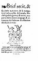 Cartier Brief recit 1545.jpg 302 × 487; 80 KB
-
 Centrale des Cèdres - 1942.jpg 333 × 204; 24 KB
-
 Centrale nucléaire Gentilly.jpg 2,487 × 1,134; 392 KB
-
 Chainiere de roches 002.jpg 3,456 × 2,304; 3.95 MB
-
 Charlevoix cote 2.jpg 3,843 × 2,499; 5.62 MB
-
 Charlevoix cote.jpg 3,822 × 2,346; 5.03 MB
-
 Charlevoix Meteorite Crater.jpg 250 × 250; 36 KB
-
 Chemin de l'Ile du Large 006.jpg 3,456 × 2,304; 3.82 MB
-
 Chios Sailor (IMO 8203476).jpg 1,971 × 1,310; 1.38 MB
-
 Chutes de Montmagny.jpg 1,920 × 1,080; 843 KB
-
 Chutes Rivière du Sud, Montmagny 01.jpg 2,592 × 1,498; 1.86 MB
-
 Chutes Rivière du Sud, Montmagny 02.jpg 2,396 × 1,044; 742 KB
-
 Château Frontenac, fleuve Saint-Laurent et Laurentides, Québec.jpg 4,486 × 2,991; 6.29 MB
-
 Cmarcoux1.JPG 2,304 × 1,728; 502 KB
-
 Cmarcoux2.JPG 2,304 × 1,728; 929 KB
-
 Cmarcoux5.JPG 2,304 × 1,728; 814 KB
-
 Complexe Rio Tinto Sorel-1.jpg 3,072 × 2,304; 650 KB
-
 Container ship levis.jpg 3,888 × 2,592; 4.29 MB
-
 Coucher de soleil fleuve saint-laurent.jpg 6,000 × 4,000; 5.28 MB
-
 Couchersoleil 011.JPG 2,848 × 1,896; 921 KB
-
 Couchersoleil 015.JPG 1,896 × 2,848; 853 KB
-
 Couchersoleil 020.JPG 2,848 × 1,896; 858 KB
-
 Couchersoleil 029.JPG 2,848 × 1,896; 948 KB
-
 The Saint Lawrence, its basin &, border-lands; the story of their discovery, exploration and occupation (IA cu31924028892417).pdf 733 × 1,079, 586 pages; 13.21 MB
-
 Cônes de percussion de Cap à la corneille.JPG 3,264 × 2,448; 2.8 MB
-
 Debris under the water at the former site of Aultsville, Ontario.jpg 3,024 × 3,024; 2.21 MB
-
 Des reflets bleu-gris sur le Saint-Laurent.jpg 4,608 × 3,072; 6.51 MB
-
 Deschambault Grondines 007.jpg 1,024 × 768; 269 KB
-
 Deschambault Grondines 020.jpg 2,496 × 1,664; 2.17 MB
-
 Deschambault Grondines 068.jpg 4,032 × 3,024; 4.31 MB
-
 Deschambault Grondines 078.jpg 4,032 × 3,024; 3.95 MB
-
 Detroit Photographic Company (0937).jpg 1,536 × 790; 234 KB
-
 Domaine Trottier 005.jpg 5,184 × 3,456; 10.21 MB
-
 Domaine Trottier 010.jpg 5,184 × 3,456; 6.26 MB
-
 Double-crested Cormorants, Thousand Islands, St Lawrence River (165475033).jpg 2,048 × 1,365; 680 KB
-
 Down By The River (IR) (50927219207).jpg 3,892 × 2,605; 3.1 MB
-
 DSCN4262 rmosesspstlawrence e.jpg 600 × 314; 45 KB
-
-
 Embouchure rivière Batiscan, Batiscan 001.jpg 1,536 × 2,048; 1.79 MB
-
 Embouchure rivière Batiscan, Batiscan 003.jpg 1,536 × 2,048; 913 KB
-
 Embouchure rivière Batiscan, Batiscan 008.jpg 2,048 × 1,536; 660 KB
-
 Embouchure rivière Batiscan, Batiscan 010.jpg 1,536 × 2,048; 719 KB
-
 EmpressofbritainII (cropped).jpg 2,110 × 1,582; 617 KB
-
 EmpressofbritainII.jpg 2,807 × 1,582; 851 KB
-
 Estuaire du Saint-Laurent, couleurs matinales (Matthieu Gauvain).JPG 2,048 × 1,536; 650 KB
-
 F.-A.-Gauthier Matane 2018.jpg 4,217 × 2,372; 2.7 MB
-
 Fahrrad-Tour am Sankt-Lorenz-Strom bei Quebec City.jpg 3,744 × 5,616; 9 MB
-
 Fairmont Richelieu - Charlevoix Quebec Canada. St. Lawrence River Canada.jpg 1,936 × 2,592; 1.49 MB
-
 Ferry Dock at Lévis (3242993856).jpg 3,888 × 2,323; 2.51 MB
-
 Ferry to Oka - Quebec 1992.jpg 2,970 × 2,049; 3.18 MB
-
 Fin de journée chaude - panoramio.jpg 2,816 × 2,112; 1.81 MB
-
 Fleuve Saint Laurent (12392694145).jpg 6,016 × 4,016; 19.21 MB


%27_(11153330153).jpg)


.jpg)


.jpg)
.JPG)


.jpg)


.jpg)
.jpg)
.jpg)


.jpg)


.jpg)


.jpg)
_(50927219207).jpg)


.jpg)

.JPG)


.jpg)


.jpg)
-Pont_Samuel_de_Champlain_illumin%C3%A9-2022-05-17.jpg)