Category:Saint Michael church in Apátfalva
Jump to navigation
Jump to search
Római katolikus templom és környezete védett
| Object location | | View all coordinates using: OpenStreetMap |
|---|
|
This is a category about a monument in Hungary. Identifier: 14618 |
Media in category "Saint Michael church in Apátfalva"
The following 4 files are in this category, out of 4 total.
-
 Apátfalva, római katolikus templom 2021 01.jpg 1,600 × 2,400; 964 KB
-
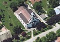 Apátfalva2.jpg 480 × 339; 39 KB
-
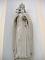
 Statue of Saint Emeric of Hungary in Apátfalva.JPG 1,728 × 2,304; 936 KB
-
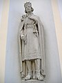
 Statue of Stephen I of Hungary in Apátfalva.JPG 1,728 × 2,304; 942 KB


