Category:San Jacinto Mountains
Vai alla navigazione
Vai alla ricerca
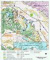
catena montuosa del sud della California  | |||||
| Carica un file multimediale | |||||
| Istanza di | |||||
|---|---|---|---|---|---|
| Luogo | California, Stati del Pacifico | ||||
| Lunghezza |
| ||||
| Catena montuosa | |||||
| Punto più alto | |||||
| Altezza sul mare |
| ||||
 | |||||
Sottocategorie
Questa categoria contiene le 11 sottocategorie indicate di seguito, su un totale di 11.
File nella categoria "San Jacinto Mountains"
Questa categoria contiene 134 file, indicati di seguito, su un totale di 134.
-
 Sr-sj-natmon-bluebound.jpg 741 × 897; 561 KB
-
 Mt San Jacinto from North.jpg 3 264 × 2 448; 3,42 MB
-
 Wpdms shdrlfi020l san bernardino mountains.jpg 300 × 275; 49 KB
-
 2014, A Large Creosote Bush, Mt. San Jacinto on the Horizon - panoramio.jpg 6 000 × 4 000; 11,5 MB
-
 Banning Pass, CA 12-28-13 (12017349935).jpg 2 070 × 1 245; 1,14 MB
-
 Bouldering.jpg 853 × 1 280; 362 KB
-
 CA62sb TwentyninePalmsHwy 1 20170910.jpg 4 896 × 2 754; 3,11 MB
-
 CA62sb TwentyninePalmsHwy 20170910.jpg 4 896 × 2 754; 3,34 MB
-
 CA62sb TwentyninePalmsHwySign 20170910.jpg 4 896 × 2 754; 3,11 MB
-
 Cahuilla Tewanet Vista Point (15398073964).jpg 5 760 × 3 840; 15,09 MB
-
 Cahuilla Tewanet Vista Point (15398138554).jpg 5 760 × 3 840; 12,69 MB
-
 Cahuilla Tewanet Vista Point (15854607137).jpg 5 465 × 3 582; 17,07 MB
-
 California - Palm Springs - NARA - 23934761.jpg 4 438 × 3 382; 1,87 MB
-
 California - San Jacinto - NARA - 23935207.jpg 4 350 × 3 382; 2,02 MB
-
 California - San Jacinto - NARA - 23935209.jpg 4 350 × 3 382; 1,85 MB
-
 California - San Jacinto - NARA - 23935211.jpg 4 350 × 3 382; 1,51 MB
-
 California - San Jacinto - NARA - 23935213.jpg 4 350 × 3 382; 2,65 MB
-
 California south tehachapi.. (1900) (14779886505).jpg 3 520 × 2 248; 4,45 MB
-
 Desert Garden Bench, Sunnylands 2-22-14b (13067180563).jpg 1 870 × 1 690; 1,24 MB
-
 Desert Garden Bench, Sunnylands 2-22-14c (13067393394).jpg 2 070 × 1 909; 1,94 MB
-
 Desert Garden Center, Sunnylands 2-22-14 (12956246763).jpg 2 070 × 1 256; 951 KB
-
 Desert Mountains 2-22-14 (12887449673).jpg 1 325 × 1 970; 1,6 MB
-
 Desert Pathway, Sunnylands, Palm Springs, CA 2-22-14a (12887451253).jpg 1 481 × 2 070; 1,39 MB
-
 Ernie Maxwell Scenic Trail - San Jacinto Mountains 1 Horizontal.jpg 8 064 × 6 048; 46,4 MB
-
 Ernie Maxwell Scenic Trail - San Jacinto Mountains 1 Vertical.jpg 6 048 × 8 064; 43,84 MB
-
 Ernie Maxwell Scenic Trail - San Jacinto Mountains 2 Horizontal.jpg 8 064 × 6 048; 37,61 MB
-
 Ernie Maxwell Scenic Trail - San Jacinto Mountains 2 Vertical.jpg 6 048 × 8 064; 39,11 MB
-
 Ernie Maxwell Scenic Trail - San Jacinto Mountains 3 Horizontal.jpg 8 064 × 6 048; 52,12 MB
-
 Ernie Maxwell Scenic Trail - San Jacinto Mountains 3 Vertical.jpg 6 048 × 8 064; 51,37 MB
-
 FMIB 33148 Lake Hemet (Cal) Masonry Dam.jpeg 703 × 922; 148 KB
-
 Fulmor Lake Reflection, CA 12-13 (15979582288).jpg 2 450 × 2 248; 3,03 MB
-
 Fulmor Lake Reflections, Idyllwild, CA 12-13 (26175048770).jpg 1 931 × 2 100; 2,13 MB
-
 Fulmor Lake, Idyllwild, CA 12-28-13c (12017634993).jpg 1 770 × 1 797; 1,77 MB
-
 Fulmor Lake, Idyllwild, CA 12-28-13d (12017703464).jpg 2 170 × 1 964; 2,35 MB
-
 Fulmor Lake, Idyllwild, CA 12-28-13g (12018174346).jpg 1 770 × 1 328; 1,15 MB
-
 Fulmor Lake, Idyllwild, CA 12-28-13j (12018171616).jpg 2 570 × 1 933; 3,12 MB
-
 Garden Bench, Sunnylands 2-22-14a (12935465925).jpg 2 070 × 1 495; 1,82 MB
-
 Heuchera hirsutissima.jpg 2 048 × 1 365; 825 KB
-
 Highway 74 from Coachella Valley Vista Point (15833142890).jpg 5 760 × 3 399; 14,29 MB
-
 Hwy 74 Turnout on the way to Idyllwild, California.jpg 8 064 × 6 048; 30,31 MB
-
 Idyllwild CA.JPG 1 936 × 2 592; 1,84 MB
-
 Idyllwild, CA 12-28-13 (12017348315).jpg 2 070 × 1 741; 1,45 MB
-
 Idyllwild, CA 12-28-13a (12017702504).jpg 1 870 × 2 202; 2,15 MB
-
 Idyllwild, CA 12-28-13b (12017702364).jpg 1 242 × 1 870; 1,44 MB
-
 Idyllwild, CA 12-28-13d (12017346305).jpg 1 970 × 1 579; 1,45 MB
-
 Idyllwild, CA 12-28-13g (12017702284).jpg 2 170 × 1 941; 2,08 MB
-
 Idyllwild, CA 12-28-13i (12017702184).jpg 1 417 × 1 870; 1,13 MB
-
 Idyllwild, CA, Church Bell 12-28-13a (12017701804).jpg 2 070 × 1 826; 1,5 MB
-
 Incensecedar sanjacintomts.JPG 1 224 × 1 632; 816 KB
-
 Inland Valley Looking Southeast From Santa Ana Mountains.jpg 8 064 × 6 048; 28,27 MB
-
 KWRP-FM San Jacinto seen from San Jacinto River Park.jpg 5 897 × 7 862; 24,94 MB
-
 Lake Fulmor Reflections12-13 (16054968213).jpg 2 426 × 2 450; 3,9 MB
-
 Lake Fulmor, Idyllwild, CA 12-28-13b (12017349525).jpg 1 770 × 1 259; 1,12 MB
-
 Lake Fulmor, San Jacinto Mountains, Idyllwild, CA 12-29-13 (11654055964).jpg 1 750 × 1 298; 675 KB
-
 Lake Fulmor, San Jacinto Mts, CA (11652412045).jpg 1 750 × 1 313; 761 KB
-
 Lake Reflection, Idyllwild, CA 2013 (14723107919).jpg 2 450 × 2 129; 1,96 MB
-
 Lodgepole pine, San Jacinto Mountains.jpg 2 304 × 3 072; 4,97 MB
-
 Manzanita1.jpg 2 592 × 1 944; 2,5 MB
-
 Map of Tahquitz Peak.png 1 608 × 1 116; 158 KB
-
 Mount San Jacinto - panoramio (1).jpg 3 888 × 2 592; 3,9 MB
-
 Mount San Jacinto - panoramio.jpg 3 273 × 1 936; 2,04 MB
-
 Mount San Jacinto From Downtown Palm Springs - panoramio.jpg 3 072 × 2 304; 2,65 MB
-
 Mount San Jacinto in California - 2010-04-21.jpg 2 592 × 1 944; 1,75 MB
-
 Mount San Jacinto Sepia - panoramio.jpg 3 888 × 2 592; 2,98 MB
-
 Mount San Jacinto, California (15470247768).jpg 4 000 × 3 000; 2,41 MB
-
 Mountains from Sunnylands Garden 2-22-14a (13067179403).jpg 2 170 × 873; 1,11 MB
-
 Mountains from Sunnylands Garden 2-22-14d (13067391694).jpg 2 270 × 1 045; 937 KB
-
 Mt. San Jacinto from Joshua Tree NP 4-13-13 (8657193369).jpg 1 750 × 1 240; 619 KB
-
 Orange Groves and San Jacinto Mountains in Valle Vista, California.jpg 8 064 × 6 048; 21,06 MB
-
 Orange Groves and San Jacinto Mountains near Valle Vista, California 2.jpg 8 064 × 6 048; 15,19 MB
-
 Orange Groves and San Jacinto Mountains near Valle Vista, California.jpg 5 140 × 3 855; 14,13 MB
-
 Palm Springs pool 2015.jpg 1 500 × 1 000; 1,62 MB
-
 Phymonotus jacintotopos wellman divide 2019.jpg 2 048 × 1 365; 1,8 MB
-
 Pinaceae forest SanJacinto2.jpg 2 272 × 1 704; 1,29 MB
-
 Leaves of California Scrub Oak.JPG 1 280 × 960; 592 KB
-
 San Gorgonio summit hiker.jpg 4 032 × 1 960; 2,19 MB
-
 San jacinto 1 from sun city.jpg 5 200 × 3 900; 11,29 MB
-
 San jacinto 3 from menifee (cropped).jpg 4 095 × 2 255; 7,71 MB
-
 San jacinto 3 from menifee.jpg 4 608 × 3 456; 9,67 MB
-
 San jacinto 4 from hemet.jpg 4 600 × 2 749; 6,46 MB
-
 San Jacinto Dry Riverbed Looking Upriver.jpg 8 064 × 6 048; 22,53 MB
-
 San Jacinto Mountain (2).jpg 3 264 × 2 448; 2,83 MB
-
 San Jacinto Mountain covered with snow - panoramio.jpg 3 264 × 2 448; 3,21 MB
-
 San Jacinto Mountain.jpg 3 264 × 2 448; 2,22 MB
-
 San Jacinto Mountains (2013).JPG 4 387 × 1 743; 3,18 MB
-
 San Jacinto Mountains - Palm Springs.jpg 4 608 × 3 456; 4,82 MB
-
 San Jacinto Mountains - panoramio.jpg 3 888 × 2 592; 2,94 MB
-
 San Jacinto Mountains aerial.jpg 5 456 × 3 632; 6,47 MB
-
 San jacinto mountains rancho mirage.jpg 4 032 × 3 024; 6,68 MB
-
 San Jacinto Mountains.jpg 1 600 × 1 049; 684 KB
-
 San Jacinto Peak 0675.jpg 2 592 × 1 944; 2,11 MB
-
 San Jacinto Peak and Abies concolor subsp. lowiana.jpg 2 136 × 1 424; 546 KB
-
 San Jacinto River Park Panorama.jpg 21 189 × 7 742; 38,55 MB
-
 San Jacinto River Park.jpg 8 064 × 6 048; 36,42 MB
-
 San Jacinto, California Neighborhood - Horizontal.jpg 8 064 × 6 048; 24,91 MB
-
 San Jacinto, California Neighborhood - Vertical.jpg 6 048 × 8 064; 26,82 MB
-
 San Jacintos from Sunnylands 2-22-14b (12794484973).jpg 1 970 × 1 764; 1,42 MB
-
 San Jacintos from Sunnylands 2-22-14d (12794816954).jpg 2 270 × 1 708; 2,13 MB
-
 San Jacintos from Sunnylands 2-22-14g (12935466005).jpg 1 970 × 1 525; 1,58 MB
-
 San Jacintos from Sunnylands 2-22-14h (12956524014).jpg 2 070 × 1 640; 2 MB
-
 San Jacintos from Sunnylands 2-22-14i (12956524714).jpg 2 170 × 1 304; 1,56 MB
-
 San Jacintos from Sunnylands 2-22-14j (12956246723).jpg 2 170 × 1 661; 2,12 MB
-
 San Jacintos from Sunnylands 2-22-14k (12997168834).jpg 1 970 × 1 858; 2,14 MB
-
 San Jacintos from Sunnylands 2-22-14l (12996901093).jpg 2 170 × 1 600; 2,19 MB
-
 San Jacintos from Sunnylands 2-22-14m (12996771885).jpg 2 170 × 1 633; 1,97 MB
-
 San-Gorgonio-pass-wind-farm IMG 6704 060421 143600.jpg 700 × 467; 383 KB
-
 SanJacintoPeakFromNorth 20150913.jpg 3 672 × 2 295; 7,92 MB
-
 Shadowrock Riparian Corridor (19090499892).jpg 478 × 640; 334 KB
-
 Snowy San Jacinto Mountains.jpg 3 199 × 2 354; 4,16 MB
-
 Suicide Rock Arlyn Asch.jpg 2 640 × 1 980; 1,76 MB
-
 Suicide Rock seen from the Devil's Slide trail.jpg 6 644 × 4 345; 11,13 MB
-
 Sunset in the San Jacinto Mountains near Idyllwild, CA (28883530164).jpg 4 500 × 2 952; 629 KB
-
 Tahquitz Rock, Idyllwild, CA 12-28-13g (12018172496).jpg 2 070 × 2 026; 1,49 MB
-
 Tahquitz Rock, Idyllwild, CA 12-28-13i (12017347345).jpg 1 770 × 1 710; 1,15 MB
-
 Tahquitz Rock, Idyllwild, CA 12-28-13j (12017701594).jpg 1 755 × 2 070; 1,75 MB
-
 Tahquitz Rock, Idyllwild, CA 12-28-13n (12018172196).jpg 2 001 × 2 040; 1,93 MB
-
 Tahquitz Rock, Idyllwild, CA 12-28-13o (12017632153).jpg 1 904 × 2 050; 2,47 MB
-
 Tahquitz Rock, Idyllwild, CA 12-28-13q (12018171006).jpg 1 770 × 1 738; 1,83 MB
-
 Tahquitz-rock2.jpg 800 × 571; 478 KB
-
 Thunderhead over the San Jacinto Mountains - panoramio (1).jpg 3 841 × 2 541; 1,75 MB
-
 Thunderhead over the San Jacinto Mountains - panoramio (2).jpg 3 884 × 2 586; 1,93 MB
-
 Thunderhead over the San Jacinto Mountains - panoramio.jpg 3 871 × 1 272; 1,17 MB
-
 Tree Shadow 2-22-14 (12935576923).jpg 2 070 × 831; 479 KB
-
 USGS - San Jacinto Fault Zone.gif 214 × 218; 16 KB
-
 View of Mount San Jacinto from Palm Springs (Riverside County), ca.1900 (CHS-1609).jpg 5 101 × 3 905; 2,41 MB
-
 FEMA - 43250 - Forrest Service water tanker stuck in California mud.jpg 3 600 × 2 400; 5,54 MB
-
 Wave cloud over Mt San Jacinto 04.04.2010.jpg 3 142 × 2 353; 1,95 MB
-
 Wide Dry River Banks of San Jacinto River California.jpg 8 064 × 6 048; 38,49 MB
-
 Winchester, California Homes Under Construction.jpg 8 064 × 6 048; 17,43 MB
-
 Lilium parryi (1).jpg 1 600 × 2 400; 435 KB
-
 Lilium parryi (2).jpg 1 600 × 2 400; 401 KB
-
 Palm Cañon - Home in the Mesquite – Chemehuevi.jpg 1 024 × 831; 225 KB
-

-
 Limberpinecone.jpg 1 788 × 3 520; 994 KB


.jpg)


.jpg)
.jpg)
.jpg)


_(14779886505).jpg)
.jpg)
.jpg)
.jpg)
.jpg)
.jpg)


_Masonry_Dam.jpeg)
.jpg)
.jpg)
.jpg)
.jpg)
.jpg)
.jpg)
.jpg)

.jpg)


.jpg)
.jpg)
.jpg)
.jpg)
.jpg)
.jpg)
.jpg)


.jpg)
.jpg)
.jpg)
.jpg)
.jpg)


.jpg)


.jpg)
.jpg)
.jpg)


.jpg)


.jpg)


.jpg)
.jpg)
.jpg)
.jpg)
.jpg)
.jpg)
.jpg)
.jpg)
.jpg)


.jpg)


.jpg)
.jpg)
.jpg)
.jpg)
.jpg)
.jpg)
.jpg)

.jpg)
.jpg)

,_ca.1900_(CHS-1609).jpg)


.jpg)
.jpg)


.jpg)
.JPG)
.jpg)