Category:Sanborn Fire Insurance Map from Montague, Muskegon County, Michigan
Jump to navigation
Jump to search
Media in category "Sanborn Fire Insurance Map from Montague, Muskegon County, Michigan"
The following 18 files are in this category, out of 18 total.
-
-
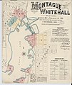
 Sanborn Fire Insurance Map from Montague, Muskegon County, Michigan. LOC sanborn04116 001-1.tif 6,510 × 7,707; 143.55 MB
-

-
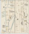
 Sanborn Fire Insurance Map from Montague, Muskegon County, Michigan. LOC sanborn04116 001-2.tif 6,510 × 7,707; 143.55 MB
-

-
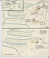
 Sanborn Fire Insurance Map from Montague, Muskegon County, Michigan. LOC sanborn04116 001-3.tif 6,510 × 7,707; 143.55 MB
-

-
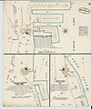
 Sanborn Fire Insurance Map from Montague, Muskegon County, Michigan. LOC sanborn04116 001-4.tif 6,510 × 7,707; 143.55 MB
-

-
 Sanborn Fire Insurance Map from Montague, Muskegon County, Michigan. LOC sanborn04116 001-5.tif 6,510 × 7,707; 143.55 MB
-

-
 Sanborn Fire Insurance Map from Montague, Muskegon County, Michigan. LOC sanborn04116 001-6.tif 6,510 × 7,707; 143.55 MB
-
-
 Sanborn Fire Insurance Map from Montague, Muskegon County, Michigan. LOC sanborn04116 001-7.tif 6,510 × 7,707; 143.55 MB
-

-
 Sanborn Fire Insurance Map from Montague, Muskegon County, Michigan. LOC sanborn04116 001-8.tif 6,510 × 7,707; 143.55 MB
-
-
 Sanborn Fire Insurance Map from Montague, Muskegon County, Michigan. LOC sanborn04116 001-9.tif 6,510 × 7,707; 143.55 MB


