Category:Sanborn maps of the Bronx published in 1896
Jump to navigation
Jump to search
Maps from: Insurance Maps of The City of New York. Volume 12. (New York: Sanborn–Perris Map Co., Limited; 1896), including title page, double-page volume key, two-page street index, and 33 maps numbered 255–284, 260½, 263½, and 266½ (all double-page plates except 279).
Source: The New York Public Library Digital Collections website, Atlas 50. Vol. 12, 1896.
Subcategories
This category has only the following subcategory.
Media in category "Sanborn maps of the Bronx published in 1896"
The following 38 files are in this category, out of 38 total.
-
 Sanborn Bronx V. 12 title page publ. 1896.jpg 4,727 × 7,259; 5.59 MB
-
 Sanborn Bronx V. 12 volume key publ. 1896.jpg 7,935 × 5,873; 8.42 MB
-
 Sanborn Bronx V. 12 street index (p.1) publ. 1896.jpg 4,900 × 7,112; 7.56 MB
-
 Sanborn Bronx V. 12 street index (p.2) publ. 1896.jpg 4,894 × 5,908; 5.46 MB
-
 Sanborn Bronx V. 12 Plate 255 publ. 1896.jpg 7,924 × 5,874; 5.28 MB
-
 Sanborn Bronx V. 12 Plate 256 publ. 1896.jpg 7,979 × 5,872; 5.84 MB
-
 Sanborn Bronx V. 12 Plate 257 publ. 1896.jpg 8,091 × 5,906; 5.71 MB
-
 Sanborn Bronx V. 12 Plate 258 publ. 1896.jpg 8,057 × 5,906; 6.08 MB
-
 Sanborn Bronx V. 12 Plate 259 publ. 1896.jpg 8,074 × 5,904; 6.75 MB
-
 Sanborn Bronx V. 12 Plate 260 publ. 1896.jpg 8,029 × 5,902; 6.55 MB
-
 Sanborn Bronx V. 12 Plate 260½ publ. 1896.jpg 8,079 × 5,897; 6.01 MB
-
 Sanborn Bronx V. 12 Plate 261 publ. 1896.jpg 8,042 × 5,916; 6.87 MB
-
 Sanborn Bronx V. 12 Plate 262 publ. 1896.jpg 8,058 × 5,900; 5.87 MB
-
 Sanborn Bronx V. 12 Plate 263 publ. 1896.jpg 8,063 × 5,911; 5.49 MB
-
 Sanborn Bronx V. 12 Plate 263½ publ. 1896.jpg 8,067 × 5,887; 6.26 MB
-
 Sanborn Bronx V. 12 Plate 264 publ. 1896.jpg 8,055 × 5,903; 6.06 MB
-
 Sanborn Bronx V. 12 Plate 265 publ. 1896.jpg 8,042 × 5,891; 5.15 MB
-
 Sanborn Bronx V. 12 Plate 266 publ. 1896.jpg 8,051 × 5,887; 6.22 MB
-
 Sanborn Bronx V. 12 Plate 266½ publ. 1896.jpg 8,009 × 5,880; 5.64 MB
-
 Sanborn Bronx V. 12 Plate 267 publ. 1896.jpg 8,017 × 5,885; 5.59 MB
-
 Sanborn Bronx V. 12 Plate 268 publ. 1896.jpg 8,060 × 5,867; 5.09 MB
-
 Sanborn Bronx V. 12 Plate 269 publ. 1896.jpg 8,084 × 5,905; 4.79 MB
-
 Sanborn Bronx V. 12 Plate 270 publ. 1896.jpg 8,090 × 5,894; 5.97 MB
-
 Sanborn Bronx V. 12 Plate 271 publ. 1896.jpg 8,092 × 5,898; 5.76 MB
-
 Sanborn Bronx V. 12 Plate 272 publ. 1896.jpg 8,053 × 5,897; 5.59 MB
-
 Sanborn Bronx V. 12 Plate 273 publ. 1896.jpg 8,078 × 5,893; 4.85 MB
-
 Sanborn Bronx V. 12 Plate 274 publ. 1896.jpg 8,072 × 5,905; 5.63 MB
-
 Sanborn Bronx V. 12 Plate 275 publ. 1896.jpg 8,059 × 5,867; 5.94 MB
-
 Sanborn Bronx V. 12 Plate 276 publ. 1896.jpg 8,090 × 5,901; 5.7 MB
-
 Sanborn Bronx V. 12 Plate 277 publ. 1896.jpg 8,075 × 5,915; 6.31 MB
-
 Sanborn Bronx V. 12 Plate 278 publ. 1896.jpg 8,073 × 5,909; 5.54 MB
-
 Sanborn Bronx V. 12 Plate 279 publ. 1896.jpg 5,054 × 7,457; 4.08 MB
-
 Sanborn Bronx V. 12 Plate 280 publ. 1896.jpg 8,049 × 5,900; 5.02 MB
-
 Sanborn Bronx V. 12 Plate 281 publ. 1896.jpg 8,072 × 5,915; 5.01 MB
-
 Sanborn Bronx V. 12 Plate 282 publ. 1896.jpg 8,046 × 5,907; 4.96 MB
-
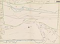 Sanborn Bronx V. 12 Plate 283 publ. 1896.jpg 8,045 × 5,904; 5.27 MB
-
 Sanborn Bronx V. 12 Plate 284 (left half) publ. 1896.jpg 4,013 × 5,932; 2.95 MB
-
 Sanborn Bronx V. 12 Plate 284 (right half) publ. 1896.jpg 4,076 × 5,902; 2.97 MB


_publ._1896.jpg)
_publ._1896.jpg)


_publ._1896.jpg)
_publ._1896.jpg)