Category:Sanborn maps of the Bronx published in 1914, V. 14
Jump to navigation
Jump to search
Maps from: Insurance Maps of The City of New York Borough of Bronx. Volume Fourteen. (New York: Sanborn Map Company, 1914), comprising 106 maps (plates) plus title page, volume key, and street index.
Online at The New York Public Library Digital Collections website, Atlas 52.1. Vol. 14, 1914.
Missing from this category are five maps whose NYPL searchable image ID numbers are:
- Plate 33: 2002985
- Plate 34: 2002986
- Plate 53: 2003005
- Plate 54: 2003006
- Plate 55: 2003007
Media in category "Sanborn maps of the Bronx published in 1914, V. 14"
The following 104 files are in this category, out of 104 total.
-

-
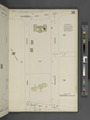
 Key NYPL2002951.tiff 6,695 × 8,934, 2 pages; 171.19 MB
-
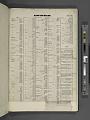 Index NYPL2002952.tiff 6,695 × 8,934, 2 pages; 171.19 MB
-
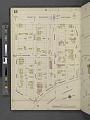
 Bronx, V. 14, Plate No. 1 (Map bounded by W. Fordham Rd., Loring Place, W. 183rd St., W. 182nd St., Cedar Ave.) NYPL2002953.tiff 6,622 × 8,837, 2 pages; 167.48 MB
-
 Bronx, V. 14, Plate No. 2 (Map bounded by W. Fordham Rd., University Ave., W. 183rd St., Loring Place) NYPL2002954.tiff 6,586 × 8,789, 2 pages; 165.67 MB
-
 Bronx, V. 14, Plate No. 3 (Map bounded by W. 184th St., Davidson Ave., W. 183rd St., University Ave.) NYPL2002955.tiff 6,701 × 8,943, 2 pages; 171.51 MB
-

-
 Bronx, V. 14, Plate No. 5 (Map bounded by Morris Ave., E. 184th St., Valentine Ave., E. 183rd St.) NYPL2002957.tiff 6,729 × 8,980, 2 pages; 172.94 MB
-
 Bronx, V. 14, Plate No. 6 (Map bounded by E. 187th St., Webster Ave., E. 183rd St., Valentine Ave.) NYPL2002958.tiff 6,612 × 8,824, 2 pages; 166.99 MB
-
 Bronx, V. 14, Plate No. 7 (Map bounded by E. 187th St., Washington Ave., E. 183rd St., Webster Ave.) NYPL2002959.tiff 6,667 × 8,897, 2 pages; 169.77 MB
-
 Bronx, V. 14, Plate No. 8 (Map bounded by E. 187th St., 3rd Ave., E. 183rd St., Washington Ave.) NYPL2002960.tiff 6,612 × 8,824, 2 pages; 166.99 MB
-
 Bronx, V. 14, Plate No. 9 (Map bounded by E. 187th St., Arthur Ave., E. 184th St., Lorillard Place) NYPL2002961.tiff 6,697 × 8,938, 2 pages; 171.32 MB
-
 Bronx, V. 14, Plate No. 10 (Map bounded by E. 187th St., Belmont Ave., E. 183rd St., Arthur Ave.) NYPL2002962.tiff 6,612 × 8,824, 2 pages; 166.99 MB
-
 Bronx, V. 14, Plate No. 11 (Map bounded by E. 187th St., Crotona Ave., Grote St., Belmont Ave.) NYPL2002963.tiff 6,697 × 8,938, 2 pages; 171.32 MB
-
 Bronx, V. 14, Plate No. 12 (Map bounded by E. 187th St., Southern Blvd., Grote St., Crotona Ave.) NYPL2002964.tiff 6,671 × 8,903, 2 pages; 169.98 MB
-
 Bronx, V. 14, Plate No. 13 (Map bounded by Arthur Ave., E. 183rd St., Cambreleng Ave., E. 182nd St.) NYPL2002965.tiff 6,732 × 8,984, 2 pages; 173.1 MB
-
 Bronx, V. 14, Plate No. 14 (Map bounded by Crotona Ave., Grote St., Southern Blvd., E. 182nd St.) NYPL2002966.tiff 6,671 × 8,903, 2 pages; 169.98 MB
-
 Bronx, V. 14, Plate No. 15 (Map bounded by University Ave., W. Fordham Rd., Jerome Ave., W. 184th St.) NYPL2002967.tiff 6,714 × 8,961, 2 pages; 172.19 MB
-
 Bronx, V. 14, Plate No. 16 (Map bounded by E. Fordham Rd., Creston Ave., E. 184th St., Jerome Ave.) NYPL2002968.tiff 6,671 × 8,903, 2 pages; 169.98 MB
-
 Bronx, V. 14, Plate No. 17 (Map bounded by E. Fordham Rd., Valentine Ave., E. 184th St., Creston Ave.) NYPL2002969.tiff 6,714 × 8,961, 2 pages; 172.19 MB
-
 Bronx, V. 14, Plate No. 18 (Map bounded by E. Fordham Rd., Marion Ave., E. 187th St., Valentine Ave.) NYPL2002970.tiff 6,671 × 8,903, 2 pages; 169.98 MB
-
 Bronx, V. 14, Plate No. 19 (Map bounded by E. Fordham Rd., Park Ave., E. 187th St., Marrion Ave.) NYPL2002971.tiff 6,714 × 8,961, 2 pages; 172.19 MB
-
 Bronx, V. 14, Plate No. 20 (Map bounded by Fordham Rd., Washington Ave., E. 187th St., Park Ave.) NYPL2002972.tiff 6,671 × 8,903, 2 pages; 169.98 MB
-
 Bronx, V. 14, Plate No. 21 (Map bounded by Washington Ave., E. 189th St., Hoffman St., E. 187th St.) NYPL2002973.tiff 6,714 × 8,961, 2 pages; 172.19 MB
-
 Bronx, V. 14, Plate No. 22 (Map bounded by Washington Ave., E. 191st St., Hoffman St., E. 189th St.) NYPL2002974.tiff 6,671 × 8,903, 2 pages; 169.98 MB
-
 Bronx, V. 14, Plate No. 23 (Map bounded by Hoffman St., E. 189thSt., Cambreleng Ave., E. 187th St.) NYPL2002975.tiff 6,706 × 8,949, 2 pages; 171.76 MB
-
 Bronx, V. 14, Plate No. 24 (Map bounded by Cambreleng Ave., E. 189th St., Southern Blvd., E. 189th St.) NYPL2002976.tiff 6,671 × 8,903, 2 pages; 169.98 MB
-
 Bronx, V. 14, Plate No. 25 (Map bounded by E. 191st St., Belmont Ave., E. 189th St., Hoffman St.) NYPL2002977.tiff 6,706 × 8,950, 2 pages; 171.78 MB
-
 Bronx, V. 14, Plate No. 26 (Map bounded by Belmont Ave., Southern Blvd., E. 189th St.) NYPL2002978.tiff 6,671 × 8,903, 2 pages; 169.98 MB
-
 Bronx, V. 14, Plate No. 27 (Map bounded by Harlem River, Hampden Pl., W. 182nd St.) NYPL2002979.tiff 6,727 × 8,978, 2 pages; 172.85 MB
-
 Bronx, V. 14, Plate No. 28 (Map bounded by Harlem River, Sedgwick Ave., W. Fordham Rd., W. 184th St.) NYPL2002980.tiff 6,671 × 8,903, 2 pages; 169.98 MB
-
 Bronx, V. 14, Plate No. 29 (Map bounded by W. 190th St., Sedgwick Ave., W. 188th St., Harlem River) NYPL2002981.tiff 6,693 × 8,933, 2 pages; 171.12 MB
-
 Bronx, V. 14, Plate No. 30 (Map bounded by W. Fordham Rd., Sedgwick Ave.) NYPL2002982.tiff 6,671 × 8,903, 2 pages; 169.98 MB
-
 Bronx, V. 14, Plate No. 31 (Map bounded by W. 190thSt., University Ave., W. Fordham Rd., Webb Ave.) NYPL2002983.tiff 6,693 × 8,933, 2 pages; 171.12 MB
-
 Bronx, V. 14, Plate No. 32 (Map bounded by W. 190thSt., Davidson Ave., W. Fordham Rd., University Ave.) NYPL2002984.tiff 6,671 × 8,903, 2 pages; 169.98 MB
-
 Bronx, V. 14, Plate No. 35 (Map bounded by W. 193rd St., Sedgwick Ave., Bailey Ave.) NYPL2002987.tiff 6,714 × 8,961, 2 pages; 172.19 MB
-
 Bronx, V. 14, Plate No. 36 (Map bounded by Kingsbridge Rd. W., Kingsbridge Terrace, Bailey Ave.) NYPL2002988.tiff 6,671 × 8,903, 2 pages; 169.98 MB
-
 Bronx, V. 14, Plate No. 37 (Map bounded by Kingsbridge Rd. W., Webb Ave., Sedgwick Ave.) NYPL2002989.tiff 6,724 × 8,974, 2 pages; 172.7 MB
-
 Bronx, V. 14, Plate No. 38 (Map bounded by Kingsbridge Rd. W., University Ave., W. 190th St., Webb Ave.) NYPL2002990.tiff 6,671 × 8,903, 2 pages; 169.98 MB
-
 Bronx, V. 14, Plate No. 39 (Map bounded by University Ave., W. 192nd St., Jerome Ave., W. 190th St.) NYPL2002991.tiff 6,715 × 8,962, 2 pages; 172.24 MB
-
 Bronx, V. 14, Plate No. 40 (Map bounded by University Ave., Kingsbridge Rd. W., Jerome Ave., W. 192nd St.) NYPL2002992.tiff 6,679 × 8,914, 2 pages; 170.4 MB
-
 Bronx, V. 14, Plate No. 41 (Map bounded by Davidson Ave., E. 190th St., Creston Ave., E. 188th St.) NYPL2002993.tiff 6,715 × 8,962, 2 pages; 172.24 MB
-
 Bronx, V. 14, Plate No. 42 (Map bounded by E. 193rd St., Cresston Ave., E. 190th St., Jerome Ave.) NYPL2002994.tiff 6,692 × 8,931, 2 pages; 171.05 MB
-
 Bronx, V. 14, Plate No. 43 (Map bounded by E. 193rd St., Valentine Ave., E. Fordham Rd., Creston Ave.) NYPL2002995.tiff 6,715 × 8,962, 2 pages; 172.24 MB
-
 Bronx, V. 14, Plate No. 44 (Map bounded by E. 194th St., Bainbridge Ave., E. Fordham Rd., Valentine Ave.) NYPL2002996.tiff 6,692 × 8,931, 2 pages; 171.05 MB
-
 Bronx, V. 14, Plate No. 45 (Map bounded by Bainbridge Ave., E. 193rd St., Fordham Rd.) NYPL2002997.tiff 6,730 × 8,981, 2 pages; 172.99 MB
-
 Bronx, V. 14, Plate No. 46 (Map bounded by E. 196th St., Creston Ave., E. 193rd St., Jerome Ave.) NYPL2002998.tiff 6,692 × 8,931, 2 pages; 171.05 MB
-
 Bronx, V. 14, Plate No. 47 (Map bounded by E. 196th St., Valentine Ave., E. 193rd St., Creston Ave.) NYPL2002999.tiff 6,617 × 8,830, 2 pages; 167.23 MB
-
 Bronx, V. 14, Plate No. 48 (Map bounded by E. 196th St., Marion Ave., E. 194th St., Valentine Ave.) NYPL2003000.tiff 6,717 × 8,964, 2 pages; 172.33 MB
-
 Bronx, V. 14, Plate No. 49 (Map bounded by Bainbridge Ave., E. 195th St., Webster Ave., E. 193rd St.) NYPL2003001.tiff 6,730 × 8,981, 2 pages; 172.99 MB
-
 Bronx, V. 14, Plate No. 50 (Map bounded by E. 198th St., Creston Ave., E. 196th St., Jerome Ave.) NYPL2003002.tiff 6,717 × 8,964, 2 pages; 172.33 MB
-
 Bronx, V. 14, Plate No. 51 (Map bounded by E. 198th St., Valentine Ave., E. 196th St., Creston Ave.) NYPL2003003.tiff 6,730 × 8,981, 2 pages; 172.99 MB
-
 Bronx, V. 14, Plate No. 52 (Map bounded by E. 198thSt., Bainbridge Ave., E. 196th St., Valentine Ave.) NYPL2003004.tiff 6,717 × 8,964, 2 pages; 172.33 MB
-
 Bronx, V. 14, Plate No. 56 (Map bounded by Bronx Park, Fordham Rd., Bathgate Ave.) NYPL2003008.tiff 6,693 × 8,932, 2 pages; 171.1 MB
-
 Bronx, V. 14, Plate No. 57 (Map bounded by Bedford Park Blvd., Grand Blvd., E. 198th St., Jerome Ave.) NYPL2003009.tiff 6,730 × 8,981, 2 pages; 172.99 MB
-
 Bronx, V. 14, Plate No. 58 (Map bounded by Bedford Park Blvd., Briggs Ave., E. 198th St., Grand Blvd.) NYPL2003010.tiff 6,693 × 8,932, 2 pages; 171.1 MB
-
 Bronx, V. 14, Plate No. 59 (Map bounded by Bedford Park Blvd., E. 198th St., Briggs Ave.) NYPL2003011.tiff 6,730 × 8,981, 2 pages; 172.99 MB
-
 Bronx, V. 14, Plate No. 60 (Map bounded by Bedford Park Blvd., E. 198th St., Marion Ave.) NYPL2003012.tiff 6,693 × 8,932, 2 pages; 171.1 MB
-
 Bronx, V. 14, Plate No. 61 (Map bounded by E. 205th St., Grand Blvd., Bedford Park Blvd., Jerome Ave.) NYPL2003013.tiff 6,709 × 8,953, 2 pages; 171.91 MB
-
 Bronx, V. 14, Plate No. 62 (Map bounded by Grand Blvd., E. 202nd St., Bainbridge Ave.) NYPL2003014.tiff 6,693 × 8,932, 2 pages; 171.1 MB
-
 Bronx, V. 14, Plate No. 63 (Map bounded by Bainbridge Ave., E. 201st St., Webster Ave., Bedford Park Blvd.) NYPL2003015.tiff 6,709 × 8,953, 2 pages; 171.91 MB
-
 Bronx, V. 14, Plate No. 64 (Map bounded by E. 204th St., Bedford Park Blvd., Webster Ave.) NYPL2003016.tiff 6,681 × 8,916, 2 pages; 170.49 MB
-
 Bronx, V. 14, Plate No. 65 (Map bounded by Grand Blvd., E. 205th St., E. Mosholu Parkway South, E. 202nd St.) NYPL2003017.tiff 6,709 × 8,953, 2 pages; 171.91 MB
-
 Bronx, V. 14, Plate No. 66 (Map bounded by E. Mosholu Parkway North, E. 201st St.., Briggs Ave.) NYPL2003018.tiff 6,690 × 8,928, 2 pages; 170.95 MB
-
 Bronx, V. 14, Plate No. 67 (Map bounded by Perry Ave., E. Mosholu Parkway North, Webster Ave., E. 201st St.) NYPL2003019.tiff 6,723 × 8,972, 2 pages; 172.63 MB
-
 Bronx, V. 14, Plate No. 68 (Map bounded by Bainbridge Ave., E. 204th St., Webster Ave., E. Mosholu Parkway North) NYPL2003020.tiff 6,690 × 8,928, 2 pages; 170.95 MB
-
 Bronx, V. 14, Plate No. 69 (Map bounded by Grand Blvd., E. 205th St., Jerome Ave.) NYPL2003021.tiff 6,728 × 8,978, 2 pages; 172.88 MB
-
 Bronx, V. 14, Plate No. 70 (Map bounded by Grand Blvd., E. Mosholu Parkway South, E. 205th St.) NYPL2003022.tiff 6,675 × 8,908, 2 pages; 170.18 MB
-
 Bronx, V. 14, Plate No. 71 (Map bounded by E. Mosholu Parkway North, E. Mosholu Parkway South) NYPL2003023.tiff 6,728 × 8,978, 2 pages; 172.88 MB
-
 Bronx, V. 14, Plate No. 72 (Map bounded by E. Mosholu Parkway North, E. 206th St., Perry Ave.) NYPL2003024.tiff 6,675 × 8,908, 2 pages; 170.18 MB
-
 Bronx, V. 14, Plate No. 73 (Map bounded by Perry Ave., E. 205th St., E. 204th St.) NYPL2003025.tiff 6,728 × 8,978, 2 pages; 172.88 MB
-
 Bronx, V. 14, Plate No. 74 (Map bounded by Jerome Ave., E. 208th St., E. Mosholu Parkway South) NYPL2003026.tiff 6,675 × 8,908, 2 pages; 170.18 MB
-
 Bronx, V. 14, Plate No. 75 (Map bounded by E. 208th St., Bainbridge Ave.,E. 206th St., E. Mosholu Parkway North) NYPL2003027.tiff 6,728 × 8,978, 2 pages; 172.88 MB
-
 Bronx, V. 14, Plate No. 76 (Map bounded by Bainbridge Ave., Holt Pl., Hull Ave.) NYPL2003028.tiff 6,657 × 8,883, 2 pages; 169.25 MB
-
 Bronx, V. 14, Plate No. 77 (Map bounded by Hull Ave., E. 207th St., E. 205th St.) NYPL2003029.tiff 6,728 × 8,978, 2 pages; 172.88 MB
-
 Bronx, V. 14, Plate No. 78 (Map bounded by Perry Ave., E. 209th St., Webster Ave., E. 207th St.) NYPL2003030.tiff 6,680 × 8,914, 2 pages; 170.42 MB
-
 Bronx, V. 14, Plate No. 79 (Map bounded by Kossuth Ave., E. 210th St., Reservoir Oval West, E. 208th St.) NYPL2003031.tiff 6,728 × 8,978, 2 pages; 172.88 MB
-
 Bronx, V. 14, Plate No. 80 (Map bounded by E. Gun Hill Rd., Steuben Ave., E. 208th St., Jerome Ave.) NYPL2003032.tiff 6,689 × 8,927, 2 pages; 170.9 MB
-
 Bronx, V. 14, Plate No. 81 (Map bounded by Steuben Ave., E. Gun Hill Rd., Tryon Ave., E. 210th St.) NYPL2003033.tiff 6,718 × 8,966, 2 pages; 172.39 MB
-
 Bronx, V. 14, Plate No. 82 (Map bounded by E. Gun Hill Rd., Perry Ave., Tryon Ave.) NYPL2003034.tiff 6,689 × 8,927, 2 pages; 170.9 MB
-
 Bronx, V. 14, Plate No. 83 (Map bounded by E. Gun Hill Rd., Parkside Place, E. 209th St., Perry Ave.) NYPL2003035.tiff 6,708 × 8,952, 2 pages; 171.87 MB
-
 Bronx, V. 14, Plate No. 84 (Map bounded by E. Gun Hill Rd., Bronx River, Parkside Place) NYPL2003036.tiff 6,721 × 8,970, 2 pages; 172.54 MB
-
 Bronx, V. 14, Plate No. 85 (Map bounded by Bainbridge Ave., E. 212th St., Jerome ave.) NYPL2003037.tiff 6,708 × 8,952, 2 pages; 171.87 MB
-
 Bronx, V. 14, Plate No. 86 (Map bounded by Jerome Ave., E. 212th St., Bainbridge Ave., E. Gun Hill Rd.) NYPL2003038.tiff 6,713 × 8,958, 2 pages; 172.11 MB
-
 Bronx, V. 14, Plate No. 87 (Map bounded by Bainbridge Ave., E. 211th St., E. Gun Hill Rd.) NYPL2003039.tiff 6,708 × 8,952, 2 pages; 171.87 MB
-
 Bronx, V. 14, Plate No. 88 (Map bounded by Putnam Pl., E. 211th St., Webster Ave., E. Gun Hill Rd.) NYPL2003040.tiff 6,731 × 8,983, 2 pages; 173.05 MB
-
 Bronx, V. 14, Plate No. 89 (Map bounded by Bronx River, E. Gun Hill Rd., Webster Ave.) NYPL2003041.tiff 6,708 × 8,952, 2 pages; 171.87 MB
-
 Bronx, V. 14, Plate No. 90 (Map bounded by Webster Ave., Bronx River) NYPL2003042.tiff 6,731 × 8,983, 2 pages; 173.05 MB
-
 Bronx, V. 14, Plate No. 91 (Map bounded by Webster Ave., Bronx River) NYPL2003043.tiff 6,708 × 8,952, 2 pages; 171.87 MB
-
 Bronx, V. 14, Plate No. 92 (Map bounded by E. 233rd St., Webster Ave., Bronx River) NYPL2003044.tiff 6,718 × 8,966, 2 pages; 172.39 MB
-
 Bronx, V. 14, Plate No. 93 (Map bounded by Napier ave., E. 233rd St., Van Cortlandt Park East) NYPL2003045.tiff 6,708 × 8,952, 2 pages; 171.87 MB
-
 Bronx, V. 14, Plate No. 94 (Map bounded by Napier Ave., E. 236th St., Kepler Ave., E. 233rd St.) NYPL2003046.tiff 6,718 × 8,966, 2 pages; 172.39 MB
-
 Bronx, V. 14, Plate No. 95 (Map bounded by Kepler Ave., E. 236th St., Katonah Ave., E. 233rd St.) NYPL2003047.tiff 6,708 × 8,952, 2 pages; 171.87 MB
-
 Bronx, V. 14, Plate No. 96 (Map bounded by Kepler Ave., E. 239th St., Katonah Ave., E. 236th St.) NYPL2003048.tiff 6,718 × 8,966, 2 pages; 172.39 MB
-
 Bronx, V. 14, Plate No. 97 (Map bounded by Napier Ave., Van Cortlandt Park East, Kepler Ave., E. 236th St.) NYPL2003049.tiff 6,702 × 8,945, 2 pages; 171.58 MB
-
 Bronx, V. 14, Plate No. 98 (Map bounded by Van Cortlandt Park East, Katonah Ave., E. 239th St.) NYPL2003050.tiff 6,718 × 8,966, 2 pages; 172.39 MB
-
 Bronx, V. 14, Plate No. 99 (Map bounded by E. 242nd St., Martha Ave., E. 238th St., Katonah Ave.) NYPL2003051.tiff 6,694 × 8,933, 2 pages; 171.14 MB
-
 Bronx, V. 14, Plate No. 100 (Map bounded by McLean Ave., Verio Ave., E. 238th St., Martha Ave.) NYPL2003052.tiff 6,689 × 8,927, 2 pages; 170.9 MB
-
 Bronx, V. 14, Plate No. 101 (Map bounded by Katonah Ave., E. 238th St., Verio Ave., E. 235th St.) NYPL2003053.tiff 6,694 × 8,933, 2 pages; 171.14 MB
-
 Bronx, V. 14, Plate No. 102 (Map bounded by McLean Ave., Bronx River, E. 235th St., Verio Ave.) NYPL2003054.tiff 6,689 × 8,927, 2 pages; 170.9 MB
-
 Bronx, V. 14, Plate No. 103 (Map bounded by Katonah Ave., E. 235th St., Webster Ave., E. 233rd St.) NYPL2003055.tiff 6,694 × 8,933, 2 pages; 171.14 MB
-
 Bronx, V. 14, Plate No. 104 (Map bounded by E. 235th St., Bronx River, E, 233rd St., Webster Ave.) NYPL2003056.tiff 6,703 × 8,945, 2 pages; 171.6 MB
-
 Bronx, V. 14, Plate No. 105 (Map bounded by Fordham Rd., Bronx River, Bronx Park South, Southern Blvd.) NYPL2003057.tiff 6,703 × 8,945, 2 pages; 171.6 MB
-
 Bronx, V. 14, Plate No. 106 (Map bounded by Webster Ave., Bronx River, Fordham Rd., Southern Blvd.) NYPL2003058.tiff 6,694 × 8,933, 2 pages; 171.14 MB