Category:Sanborn maps of the Bronx published in 1918
Jump to navigation
Jump to search
Maps from: Insurance Maps of the City of New York Borough of Bronx. Volume 18. (New York: Sanborn Map Company, 1918), comprising 100 maps (plates) plus title page (source is incomplete), volume key, two-page street index, and additional "new sheets" for Plates 59, 60, and 72.
Online at The New York Public Library Digital Collections website, Atlas 55. Vol. 18, 1918.
Missing from this category are the volume key, the first street index page, and 16 maps, whose NYPL searchable Image ID numbers are:
- Plate 7: 2001608
- Plate 12: 2001613
- Plate 70: 2001673
- Plate 71: 2001674
- Plate 72 New Sheet: 2001676
- Plate 75: 2001679
- Plate 76: 2001680
- Plate 77: 2001681
- Plate 79: 2001683
- Plate 81: 2001685
- Plate 83: 2001687
- Plate 84: 2001688
- Plate 85: 2001689
- Plate 86: 2001690
- Plate 87: 2001691
- Plate 100: 2001704
Media in category "Sanborn maps of the Bronx published in 1918"
The following 89 files are in this category, out of 89 total.
-
 Insurance maps of the City of New York, Borough of Bronx. Volume 18. Published by the Sanborn Map Company, 1918. NYPL2001598.tiff 6,732 × 8,984, 2 pages; 173.1 MB
-
 Index continued NYPL2001600.tiff 6,667 × 8,897, 2 pages; 169.77 MB
-
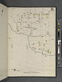
 Bronx, V. 18, Plate No. 1 (Map bounded by Magenta St., White Planes Rd., Adee Ave., Bronx Blvd.) NYPL2001602.tiff 6,667 × 8,897, 2 pages; 169.77 MB
-
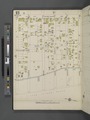
 Bronx, V. 18, Plate No. 2 (Map bounded by Magenta St., Barnes Ave., Adee Ave., White Plains Rd.) NYPL2001603.tiff 6,667 × 8,897, 2 pages; 169.77 MB
-
 Bronx, V. 18, Plate No. 3 (Map bounded by Bronx Blvd., Gun Hill Rd., White Plains Rd., Magenta St.) NYPL2001604.tiff 6,732 × 8,983, 2 pages; 173.08 MB
-
 Bronx, V. 18, Plate No. 4 (Map bounded by Bronx Blvd., E. 213th St., White Plains Rd., Gun Hill Rd.) NYPL2001605.tiff 6,667 × 8,897, 2 pages; 169.77 MB
-
 Bronx, V. 18, Plate No. 5 (Map bounded by E. 215th St., Barnes Ave., Magenta St., White Plains Rd.) NYPL2001606.tiff 6,732 × 8,983, 2 pages; 173.08 MB
-
 Bronx, V. 18, Plate No. 6 (Map bounded by E. 215th St., Paulding Ave., Magenta St., Barnes Ave.) NYPL2001607.tiff 6,667 × 8,897, 2 pages; 169.77 MB
-
 Bronx, V. 18, Plate No. 8 (Map bounded by Bronx Blvd., E. 222nd St., Bronx Blvd.) NYPL2001609.tiff 6,667 × 8,897, 2 pages; 169.77 MB
-
 Bronx, V. 18, Plate No. 9 (Map bounded by E. 220th St., White Plains Rd., E. 216th St., Bronx Blvd.) NYPL2001610.tiff 6,712 × 8,957, 2 pages; 172.06 MB
-
 Bronx, V. 18, Plate No. 10 (Map bounded by E. 220th St., Barnes Ave., E. 215th St., White Plains Rd.) NYPL2001611.tiff 6,667 × 8,897, 2 pages; 169.77 MB
-
 Bronx, V. 18, Plate No. 11 (Map bounded by E. 225th St., White Plains Rd., E. 220th St., Carpenter Ave.) NYPL2001612.tiff 6,719 × 8,966, 2 pages; 172.42 MB
-
 Bronx, V. 18, Plate No. 13 (Map bounded by E. 230th St., White Plains Rd., E. 225th St., Carpenter Ave.) NYPL2001614.tiff 6,719 × 8,966, 2 pages; 172.42 MB
-
 Bronx, V. 18, Plate No. 14 (Map bounded by E. 230th St., Barnes Ave., E. 225th St., White Plains Rd.) NYPL2001615.tiff 6,667 × 8,897, 2 pages; 169.77 MB
-
 Bronx, V. 18, Plate No. 15 (Map bounded by Bronx Blvd., E. 229th St., Carpenter Ave., E. 222nd St.) NYPL2001616.tiff 6,728 × 8,978, 2 pages; 172.88 MB
-

-
 Bronx, V. 18, Plate No. 17 (Map bounded by E. 235th St., White Plains Rd., E. 230th St., Carpenter Ave.) NYPL2001618.tiff 6,728 × 8,978, 2 pages; 172.88 MB
-
 Bronx, V. 18, Plate No. 18 (Map bounded by E. 235th St., Barnes Ave., E. 230th St., White Plains Rd.) NYPL2001619.tiff 6,667 × 8,897, 2 pages; 169.77 MB
-
 Bronx, V. 18, Plate No. 19 (Map bounded by Nereid Ave., White Plains Rd., E. 235th St., Carpenter Ave.) NYPL2001620.tiff 6,671 × 8,903, 2 pages; 169.98 MB
-
 Bronx, V. 18, Plate No. 20 (Map bounded by Nereid Ave., Barnes Ave., E. 235th St., White Plains Rd.) NYPL2001621.tiff 6,680 × 8,914, 2 pages; 170.42 MB
-
 Bronx, V. 18, Plate No. 21 (Map bounded by E. 239th St., Carpenter Ave., 236th St., Bronx River) NYPL2001622.tiff 6,706 × 8,949, 2 pages; 171.76 MB
-
 Bronx, V. 18, Plate No. 22 (Map bounded by E. 241st St., Bronx Blvd., Oakley Ave.) NYPL2001623.tiff 6,680 × 8,914, 2 pages; 170.42 MB
-
 Bronx, V. 18, Plate No. 23 (Map bounded by Bronx Blvd., E. 239th St., Furman Ave., Nereid Ave.) NYPL2001624.tiff 6,663 × 8,893, 2 pages; 169.59 MB
-
 Bronx, V. 18, Plate No. 24 (Map bounded by Bronx Blvd., E. 240th St., White Plains Rd., E. 239th St.) NYPL2001625.tiff 6,680 × 8,914, 2 pages; 170.42 MB
-
 Bronx, V. 18, Plate No. 25 (Map bounded by Bronx River, E. 242nd St., Carpenter Ave., E. 241st St.) NYPL2001626.tiff 6,682 × 8,917, 2 pages; 170.53 MB
-
 Bronx, V. 18, Plate No. 26 (Map bounded by Bronx River Rd., Baldwin St., Bronx St.) NYPL2001627.tiff 6,680 × 8,914, 2 pages; 170.42 MB
-
 Bronx, V. 18, Plate No. 27 (Map bounded by Bronx Blvd., E. 241st St., White Plains Rd., E. 240th St.) NYPL2001628.tiff 6,658 × 8,885, 2 pages; 169.31 MB
-
 Bronx, V. 18, Plate No. 28 (Map bounded by South St., White Plains Rd., E. 241st St., Carpenter Ave.) NYPL2001629.tiff 6,680 × 8,914, 2 pages; 170.42 MB
-
 Bronx, V. 18, Plate No. 29 (Map bounded by Bruner Ave., Bissel Ave., Wilder Ave., Nereid Ave.) NYPL2001630.tiff 6,669 × 8,900, 2 pages; 169.87 MB
-
 Bronx, V. 18, Plate No. 30 (Map bounded by E. 240th St., White Plains Rd., St. Ouen St., Wilder Ave., Bissel Ave.) NYPL2001631.tiff 6,703 × 8,946, 2 pages; 171.62 MB
-
 Bronx, V. 18, Plate No. 31 (Map bounded by Wilder Ave., W. 3rd St., S. 11th Ave., Bissel Ave.) NYPL2001632.tiff 6,700 × 8,942, 2 pages; 171.47 MB
-
 Bronx, V. 18, Plate No. 32 (Map bounded by White Plains Rd., South St., St. Ouen St.) NYPL2001633.tiff 6,716 × 8,962, 2 pages; 172.26 MB
-
 Bronx, V. 18, Plate No. 33 (Map bounded by E. 237th St., Byron Ave., Nereid Ave., Ely Ave., Pitman Ave.) NYPL2001634.tiff 6,711 × 8,956, 2 pages; 172.02 MB
-
 Bronx, V. 18, Plate No. 34 (Map bounded by E. 240th St., Bruner Ave., Nereid Ave.) NYPL2001635.tiff 6,716 × 8,962, 2 pages; 172.26 MB
-
 Bronx, V. 18, Plate No. 35 (Map bounded by Ely Ave., Nereid Ave., Wilder Ave., Pitman Ave.) NYPL2001636.tiff 6,699 × 8,939, 2 pages; 171.39 MB
-
 Bronx, V. 18, Plate No. 36 (Map bounded by Wilder Ave., Nereid Ave., Pitman Ave.) NYPL2001637.tiff 6,716 × 8,962, 2 pages; 172.26 MB
-
 Bronx, V. 18, Plate No. 37 (Map bounded by Wilder Ave., Bissel Ave., Mundy Lane, Nereid Ave.) NYPL2001638.tiff 6,684 × 8,920, 2 pages; 170.64 MB
-
 Bronx, V. 18, Plate No. 38 (Map bounded by Pitman Ave., Seton Ave., Edenwald Ave., De Reimer Ave.) NYPL2001639.tiff 6,716 × 8,962, 2 pages; 172.26 MB
-
 Bronx, V. 18, Plate No. 39 (Map bounded by Pitman Ave., Bruner Ave., Edenwald Ave., Bronxwood Ave.) NYPL2001640.tiff 6,684 × 8,920, 2 pages; 170.64 MB
-
 Bronx, V. 18, Plate No. 40 (Map bounded by Pitman Ave., De Reimer Ave., Edenwald Ave., Bruner Ave.) NYPL2001641.tiff 6,727 × 8,977, 2 pages; 172.83 MB
-
 Bronx, V. 18, Plate No. 41 (Map bounded by E. 220th St., Bronxwood Ave., E. 215th St., Barnes Ave.) NYPL2001642.tiff 6,649 × 8,874, 2 pages; 168.87 MB
-
 Bronx, V. 18, Plate No. 42 (Map bounded by E. 225th St., Bronxwood Ave., E. 220th St., Barnes Ave.) NYPL2001643.tiff 6,727 × 8,977, 2 pages; 172.83 MB
-
 Bronx, V. 18, Plate No. 43 (Map bounded by E. 230th St., Bronxwood Ave., E. 225th St., Barnes Ave.) NYPL2001644.tiff 6,684 × 8,920, 2 pages; 170.64 MB
-
 Bronx, V. 18, Plate No. 44 (Map bounded by Bronxwood Ave., E. 230th St., Barnes Ave.) NYPL2001645.tiff 6,727 × 8,977, 2 pages; 172.83 MB
-
 Bronx, V. 18, Plate No. 45 (Map bounded by Bronxwood Ave., E. 220th St., E. 215th St.) NYPL2001646.tiff 6,684 × 8,920, 2 pages; 170.64 MB
-
 Bronx, V. 18, Plate No. 46 (Map bounded by Bronxwood Ave., E. 225th St., Laconia Ave., E. 220th St.) NYPL2001647.tiff 6,727 × 8,977, 2 pages; 172.83 MB
-
 Bronx, V. 18, Plate No. 47 (Map bounded by Bronxwood Ave., E. 230th St., Laconia Ave., E. 225th St.) NYPL2001648.tiff 6,684 × 8,920, 2 pages; 170.64 MB
-
 Bronx, V. 18, Plate No. 48 (Map bounded by Bronxwood Ave., Laconia Ave., E. 230th St.) NYPL2001649.tiff 6,727 × 8,977, 2 pages; 172.83 MB
-
 Bronx, V. 18, Plate No. 49 (Map bounded by Edenwald Ave., De Reimer Ave., Grenada Pl., Laconia Ave.) NYPL2001650.tiff 6,684 × 8,920, 2 pages; 170.64 MB
-
 Bronx, V. 18, Plate No. 50 (Map bounded by Edenwald Ave., Seton Ave., E. 233rd St., De Reimer Ave.) NYPL2001651.tiff 6,727 × 8,977, 2 pages; 172.83 MB
-
 Bronx, V. 18, Plate No. 51 (Map bounded by Harper Ave., E. 233rd St., Seton Ave.) NYPL2001652.tiff 6,666 × 8,896, 2 pages; 169.72 MB
-
 Bronx, V. 18, Plate No. 52 (Map bounded by Merritt Ave., Conner St., Happer Ave.) NYPL2001653.tiff 6,727 × 8,977, 2 pages; 172.83 MB
-
 Bronx, V. 18, Plate No. 53 (Map bounded by Magenta St., Paulding Ave., Adee Ave., Barnes Ave.) NYPL2001654.tiff 6,692 × 8,930, 2 pages; 171.03 MB
-
 Bronx, V. 18, Plate No. 54 (Map bounded by Gun Hill Rd., Hering Ave., Adee Ave., Paulding Ave.) NYPL2001655.tiff 6,727 × 8,977, 2 pages; 172.83 MB
-
 Bronx, V. 18, Plate No. 55 (Map bounded by Hering Ave., Fish Ave., Adee Ave.) NYPL2001656.tiff 6,701 × 8,942, 2 pages; 171.49 MB
-
 Bronx, V. 18, Plate No. 56 (Map bounded by Wilson Ave., Givan Ave., Kingsland Ave., Hammersley Ave.) NYPL2001657.tiff 6,727 × 8,977, 2 pages; 172.83 MB
-
 Bronx, V. 18, Plate No. 57 (Map bounded by Paulding Ave., Wilson Ave., Boston Rd., Gun Hill Rd.) NYPL2001658.tiff 6,701 × 8,942, 2 pages; 171.49 MB
-
 Bronx, V. 18, Plate No. 58 (Map bounded by Needham Ave., Corsa Ave., Givan Ave., Pearsall Ave.) NYPL2001659.tiff 6,727 × 8,977, 2 pages; 172.83 MB
-
 Bronx, V. 18, Plate No. 59 (Map bounded by E. 222nd St., Needham Ave., Fish Ave., Laconia Ave.) NYPL2001661.tiff 6,697 × 8,937, 2 pages; 171.3 MB
-
 Bronx, V. 18, Plate No. 59 (Map bounded by Mickle Ave., Fish Ave., Laconia Ave.) NYPL2001660.tiff 6,692 × 8,931, 2 pages; 171.05 MB
-
 Bronx, V. 18, Plate No. 60 (Map bounded by Laconia Ave., E. 225th St., Boston Rd., E. 222nd St.) NYPL2001662.tiff 6,697 × 8,937, 2 pages; 171.3 MB
-
 Bronx, V. 18, Plate No. 60 (Map bounded by Laconia Ave., Edson Ave., Schieffeln Ave.) NYPL2001663.tiff 6,648 × 8,872, 2 pages; 168.81 MB
-
 Bronx, V. 18, Plate No. 61 (Map bounded by E. 233rd St., Needham Ave., Edson Ave.) NYPL2001664.tiff 6,692 × 8,931, 2 pages; 171.05 MB
-
 Bronx, V. 18, Plate No. 62 (Map bounded by E. 233rd St., Harper Ave., Needham Ave.) NYPL2001665.tiff 6,668 × 8,898, 2 pages; 169.81 MB
-
 Bronx, V. 18, Plate No. 63 (Map bounded by Varian Ave., Hollers Ave., Provost Ave., Givan Ave.) NYPL2001666.tiff 6,699 × 8,939, 2 pages; 171.39 MB
-
 Bronx, V. 18, Plate No. 64 (Map bounded by Varin Ave., Harper Ave., Conner St., Merritt Ave., Hollers Ave.) NYPL2001667.tiff 6,668 × 8,898, 2 pages; 169.81 MB
-
 Bronx, V. 18, Plate No. 65 (Map bounded by Hollers Ave., Merritt Ave.) NYPL2001668.tiff 6,717 × 8,964, 2 pages; 172.33 MB
-
 Bronx, V. 18, Plate No. 66 (Map bounded by Boston Rd., Huguenot Ave., Hollers Ave.) NYPL2001669.tiff 6,668 × 8,898, 2 pages; 169.81 MB
-
 Bronx, V. 18, Plate No. 67 (Map bounded by Provost Ave., Hollers Ave., Givan Ave.) NYPL2001670.tiff 6,717 × 8,964, 2 pages; 172.33 MB
-
 Bronx, V. 18, Plate No. 68 (Map bounded by Boston Rd., Pelham Bay Park West) NYPL2001671.tiff 6,668 × 8,898, 2 pages; 169.81 MB
-
 Bronx, V. 18, Plate No. 69 (Map bounded by Needham Ave., Wickham Ave., Givan Ave., Corsa Ave.) NYPL2001672.tiff 6,717 × 8,964, 2 pages; 172.33 MB
-
 Bronx, V. 18, Plate No. 72 (Map bounded by Mickle Ave., Schieffelin Ave., Edson Ave., Needham Ave.) NYPL2001675.tiff 6,668 × 8,898, 2 pages; 169.81 MB
-
 Bronx, V. 18, Plate No. 73 (Map bounded by Kingsland Ave., Givan Ave., Edson Ave., Hammersley Ave.) NYPL2001677.tiff 6,717 × 8,964, 2 pages; 172.33 MB
-
 Bronx, V. 18, Plate No. 74 (Map bounded by Edson Ave., Givan Ave., Varian Ave., Hammersley Ave.) NYPL2001678.tiff 6,668 × 8,898, 2 pages; 169.81 MB
-
 Bronx, V. 18, Plate No. 78 (Map bounded by Hammersley Ave., Baychester Ave., Bartow Ave., Gunther Ave.) NYPL2001682.tiff 6,654 × 8,880, 2 pages; 169.11 MB
-
 Bronx, V. 18, Plate No. 80 (Map bounded by Hammersley Ave., Hutchinson Ave., Bartow Ave., Varian Ave.) NYPL2001684.tiff 6,654 × 8,880, 2 pages; 169.11 MB
-
 Bronx, V. 18, Plate No. 82 (Map bounded by Bartow Ave., Varian Ave., Mace Ave., Baychester Ave.) NYPL2001686.tiff 6,684 × 8,920, 2 pages; 170.64 MB
-
 Bronx, V. 18, Plate No. 88 (Map bounded by Elizabeth St., Minnieford Ave., Bowne St.) NYPL2001692.tiff 6,648 × 8,871, 2 pages; 168.79 MB
-
 Bronx, V. 18, Plate No. 89 (Map bounded by Elizabeth St., Bowne St., Minnieford Ave.) NYPL2001693.tiff 6,719 × 8,967, 2 pages; 172.44 MB
-
 Bronx, V. 18, Plate No. 90 (Map bounded by City Island Ave., Bay St., Bowne St.) NYPL2001694.tiff 6,696 × 8,936, 2 pages; 171.25 MB
-
 Bronx, V. 18, Plate No. 91 (Map bounded by Long Island Sound, Fordham St., City Island Ave., Bowne St.) NYPL2001695.tiff 6,719 × 8,967, 2 pages; 172.44 MB
-
 Bronx, V. 18, Plate No. 92 (Map bounded by Long Island Sound, Centre St., City Island Ave., Bay St.) NYPL2001696.tiff 6,696 × 8,936, 2 pages; 171.25 MB
-
 Bronx, V. 18, Plate No. 93 (Map bounded by City Island Ave., Centre St., Long Island Sound, Bay St.) NYPL2001697.tiff 6,719 × 8,967, 2 pages; 172.44 MB
-
 Bronx, V. 18, Plate No. 94 (Map bounded by Centre St., City Island Ave., Horton St., Long Island Sound) NYPL2001698.tiff 6,687 × 8,924, 2 pages; 170.79 MB
-
 Bronx, V. 18, Plate No. 95 (Map bounded by Centre St., Long Island Sound, Horton St., City Island Ave.) NYPL2001699.tiff 6,719 × 8,967, 2 pages; 172.44 MB
-
 Bronx, V. 18, Plate No. 96 (Map bounded by Long Island Sound, Horton St.) NYPL2001700.tiff 6,710 × 8,955, 2 pages; 171.97 MB
-
 Bronx, V. 18, Plate No. 97 (Map bounded by Hunters Island, City Island, Pelham Bay Park) NYPL2001701.tiff 6,719 × 8,967, 2 pages; 172.44 MB
-
 Bronx, V. 18, Plate No. 98 (Map bounded by Details Buildings in Pelham Bay Park) NYPL2001702.tiff 6,710 × 8,955, 2 pages; 171.97 MB
-
 Bronx, V. 18, Plate No. 99 (Map bounded by Naval Training Camp Pelham Bay Park) NYPL2001703.tiff 6,719 × 8,967, 2 pages; 172.44 MB