Category:Sandgruber
Jump to navigation
Jump to search
| Object location | | View all coordinates using: OpenStreetMap |
|---|
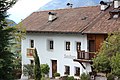
| This category shows the cultural heritage monument with the number 17574 in South Tyrol. (Wikidata)
|
Deutsch: Sandgruber in Dorf Tirol
| Upload media | |||||
| Instance of | |||||
|---|---|---|---|---|---|
| Location | Tirol, South Tyrol, Trentino-South Tyrol, Italy | ||||
| Heritage designation | |||||
 | |||||
Media in category "Sandgruber"
The following 4 files are in this category, out of 4 total.
-
 Sandgruber in Dorf Tirol - Gemälde (Fresken) an der Südfront.JPG 2,925 × 1,902; 723 KB
-
 Sandgruber in Dorf Tirol - Nord.JPG 4,984 × 2,657; 3.45 MB
-
 Sandgruber in Dorf Tirol - Süd (2).JPG 5,184 × 3,456; 7.78 MB
-
 Sandgruber in Dorf Tirol - Süd.JPG 3,270 × 1,920; 1.46 MB
_an_der_S%C3%BCdfront.JPG)

.JPG)
