Category:Sandoy
Jump to navigation
Jump to search

island in the Faroe Islands   | |||||
| Upload media | |||||
| Instance of | |||||
|---|---|---|---|---|---|
| Part of | |||||
| Location |
| ||||
| Located in or next to body of water | |||||
| Capital | |||||
| Highest point | |||||
| Population |
| ||||
| Area |
| ||||
| Different from | |||||
 | |||||
Subcategories
This category has the following 18 subcategories, out of 18 total.
B
- Heðin Brú (1 P, 5 F)
C
D
G
- Gróthúsvatn (1 F)
H
I
- Inni í Dal (10 F)
N
- Nature of Sandoy (1 F)
R
- Remote views of Sandoy (1 F)
S
- Sandsvatn (3 F)
- Sildberin (ship, 1994) (1 F)
- Skarvanes (1 P, 11 F)
- Stóravatn, Sandoy (3 F)
T
Pages in category "Sandoy"
The following 7 pages are in this category, out of 7 total.
Media in category "Sandoy"
The following 21 files are in this category, out of 21 total.
-
 B71 Sandoy players just after scoring a goal on 2 May 2010 Inni í Dal.JPG 3,648 × 2,736; 2.11 MB
-
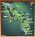 Detailed map sandoy 2006.jpg 829 × 863; 514 KB
-
 Down to the Sandy Beach of Sandur Faroe Islands 2012.JPG 4,608 × 3,456; 6.48 MB
-
 Faroe stamp 005 west coast of sandoy 70 oyru.jpg 301 × 233; 31 KB
-
 Faroese stamp 570 Sandoy.jpg 365 × 279; 40 KB
-
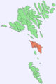 Position of Sandoy on Faroe map.png 688 × 1,035; 19 KB
-
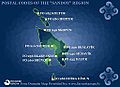 PostnummurSandoy.jpg 571 × 413; 50 KB
-
 Route 60 Streymoy Sandoy (map, Faroe).jpg 591 × 507; 63 KB
-
 Sandoy aerial 2019 a.jpg 4,000 × 2,670; 1.58 MB
-
 Sandoy aerial 2019 b.jpg 3,580 × 2,310; 1.24 MB
-
 Sandoy and Trøllhøvdið in Snow in February 2010.JPG 3,648 × 2,736; 2.17 MB
-
 Sandoy Faroe Islands view to small islands.JPG 4,608 × 3,456; 5.95 MB
-
 Sandoy kort.PNG 569 × 672; 81 KB
-
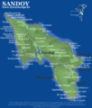
 Sandoy map.jpg 618 × 728; 79 KB
-
 Sandoy, Trøllhøvdið, Hestur, Koltur and Streymoy Faroe Islands.JPG 3,648 × 2,736; 2.01 MB
-
 Sandoy.jpg 1,024 × 768; 77 KB
-
 Sandsvágur og mølheyggjar á Sandi juli 2012.JPG 4,608 × 3,456; 6.25 MB
-
 Sandur aerial 3.jpg 3,800 × 2,450; 1.72 MB
-
 Sandur aerial 4.jpg 3,000 × 2,000; 1.31 MB
-
 Sandur-skugvoy.png 573 × 353; 244 KB
-
 Í Trøðum, Sandoy 2005.jpg 896 × 596; 224 KB


.jpg)


