Category:Sanne kyrka
Jump to navigation
Jump to search
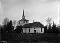
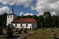
Svenska: Sanne kyrka tillhör Sörbygdens församling, Norra Bohusläns kontrakt, Göteborg stift / Diocese of Gothenburg.
| Object location | | View all coordinates using: OpenStreetMap |
|---|
|
This is a category about an ecclesiastical monument in Sweden, number 21300000002852 in the RAÄ buildings database.
|
church building in Munkedal Municipality, Gothenburg and Bohus County, Sweden  | |||||
| Upload media | |||||
| Instance of | |||||
|---|---|---|---|---|---|
| Location | Munkedal Municipality, Västra Götaland County, Sweden | ||||
| Diocese | |||||
| Has use |
| ||||
| Occupant | |||||
| Heritage designation |
| ||||
 | |||||
Media in category "Sanne kyrka"
The following 12 files are in this category, out of 12 total.
-
 Sanne kyrka - KMB - 16000200005581.jpg 800 × 582; 91 KB
-
 Sanne kyrka - KMB - 16000200005585.jpg 800 × 530; 77 KB
-
 Sanne kyrka - KMB - 16000200005588.jpg 800 × 542; 77 KB
-
 Sanne kyrka - KMB - 16000200005592.jpg 800 × 537; 102 KB
-
 Sanne kyrka - KMB - 16000200005597.jpg 800 × 583; 82 KB
-
 Sanne kyrka - KMB - 16000200005600.jpg 800 × 588; 128 KB
-
 Sanne kyrka - KMB - 16000200005601.jpg 430 × 600; 65 KB
-
 Sanne kyrka - KMB - 16000200005614.jpg 800 × 594; 72 KB
-
 Sanne kyrka - KMB - 16000200005619.jpg 800 × 574; 83 KB
-
 Sanne kyrka - KMB - 16000200005620.jpg 343 × 600; 37 KB
-
 Sanne kyrka old1.jpg 800 × 575; 83 KB
-
 Sanne kyrka, 2014.jpg 1,500 × 1,000; 505 KB


