Category:Sant'Andrea (Montebuono, Sorano)
Jump to navigation
Jump to search
| Object location | | View all coordinates using: OpenStreetMap |
|---|
church in Montebuono (Appalto), Sorano  | |||||
| Upload media | |||||
| Instance of | |||||
|---|---|---|---|---|---|
| Named after | |||||
| Location | Montebuono, Sorano, Province of Grosseto, Tuscany, Italy | ||||
| Diocese | |||||
| Religion or worldview | |||||
 | |||||
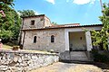
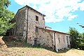
English: Church Sant'Andrea, in Montebuono (Appalto), hamlet of Sorano, Province of Grosseto, Tuscany, Italy
Media in category "Sant'Andrea (Montebuono, Sorano)"
The following 3 files are in this category, out of 3 total.
-
 MontebuonoAppaltoSoranoAndrea1.jpg 5,150 × 3,426; 14.15 MB
-
 MontebuonoAppaltoSoranoAndrea2.jpg 5,084 × 3,382; 5.94 MB
-
 MontebuonoAppaltoSoranoAndrea3.jpg 3,456 × 5,184; 7.93 MB

