Category:Sant Roc de les Avellanes
Jump to navigation
Jump to search
| Object location | | View all coordinates using: OpenStreetMap |
|---|
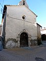
church building in Les Avellanes i Santa Linya, Spain  | |||||
| Upload media | |||||
| Instance of | |||||
|---|---|---|---|---|---|
| Part of | |||||
| Location | Les Avellanes i Santa Linya, Noguera, Ponent, Lleida Province, Catalonia | ||||
| Street address |
| ||||
| Architectural style | |||||
| Heritage designation |
| ||||
| Inception |
| ||||
| Elevation above sea level |
| ||||
 | |||||
Català: Capella de Sant Roc de les Avellanes (les Avellanes i Santa Linya)
This is a category about a building listed in the Catalan heritage register as Bé Cultural d'Interès Local (BCIL) under the reference IPA-22052. |
Subcategories
This category has only the following subcategory.
Media in category "Sant Roc de les Avellanes"
The following 3 files are in this category, out of 3 total.
-
 SANT ROC DE LES AVELLANES - IB-965.jpg 1,536 × 2,048; 976 KB
-
 SANT ROC DE LES AVELLANES - IB-966.jpg 1,536 × 2,048; 953 KB
-
 SANT ROC DE LES AVELLANES - IB-967.jpg 2,048 × 1,536; 1,011 KB

