Category:Schallfelder Straße 1 (Gerolzhofen)
Jump to navigation
Jump to search
| Object location | | View all coordinates using: OpenStreetMap |
|---|
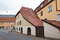
cultural heritage monument D-6-78-134-106 (0) in Gerolzhofen, Bavaria  | |||||
| Upload media | |||||
| Instance of | |||||
|---|---|---|---|---|---|
| Location | Gerolzhofen, Schweinfurt, Lower Franconia, Bavaria, Germany | ||||
| Street address |
| ||||
| Heritage designation | |||||
 | |||||
This is the category of the Bavarian Baudenkmal (cultural heritage monument) with the ID D-6-78-134-106 (Wikidata)
|
Deutsch: Wohnhaus. Eineinhalbgeschossiger Halbwalmdachbau mit Fachwerk, 17./18. Jahrhundert. Schallfelder Straße 1, Gerolzhofen, Unterfranken, Deutschland
Media in category "Schallfelder Straße 1 (Gerolzhofen)"
The following 6 files are in this category, out of 6 total.
-
 Gerolzhofen, Schallfelder Straße 1-001.jpg 4,928 × 3,264; 7.86 MB
-
 Gerolzhofen, Schallfelder Straße 1-002.jpg 4,928 × 3,264; 7.34 MB
-
 Gerolzhofen, Schallfelder Straße 1-003.jpg 4,928 × 3,264; 7.84 MB
-
 Gerolzhofen, Schallfelder Straße 1-20160131-001.jpg 6,016 × 4,016; 12.02 MB
-
 Schallfelder Straße 1 Gerolzhofen 20210314 002.jpg 6,016 × 4,016; 11.05 MB
-
 Schallfelder Straße 1 Gerolzhofen 20210314 003.jpg 5,605 × 3,742; 11.07 MB


