Category:Schillig range rear
Jump to navigation
Jump to search
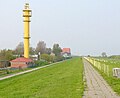
English: The Schillig range rear light was active from 1961 until 1987. The building is still in use as antenna tower for the
Wasser- und Schifffahrtsamt Wilhelmshaven.
| Object location | | View all coordinates using: OpenStreetMap |
|---|
lighthouse in Germany  | |||||
| Upload media | |||||
| Instance of |
| ||||
|---|---|---|---|---|---|
| Part of |
| ||||
| Made from material | |||||
| Location | Wangerland, Friesland (district), Lower Saxony, Germany | ||||
| Located in or next to body of water | |||||
| Service retirement |
| ||||
| Inception |
| ||||
| Height |
| ||||
 | |||||
Media in category "Schillig range rear"
The following 5 files are in this category, out of 5 total.
-
 Imagedrohne.com Luftbild Schillig Leuchtfeuer - panoramio.jpg 1,285 × 856; 1.02 MB
-
 Schillig 7086.JPG 2,592 × 1,944; 933 KB
-
 Schillig Leuchtturm.jpg 669 × 547; 112 KB
-
 Schillig range rear 0455.jpg 3,024 × 2,094; 1.26 MB
-
 Schillig range rear 0457.jpg 2,970 × 2,056; 1,014 KB


