Category:Schloss-Brücke (Zwingen)
Jump to navigation
Jump to search
| Object location | | View all coordinates using: OpenStreetMap |
|---|
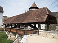
covered wooden bridge and part of an architectural ensemble in Zwingen in the canton of Basel-Landschaft, Switzerland.  | |||||
| Upload media | |||||
| Instance of | |||||
|---|---|---|---|---|---|
| Part of |
| ||||
| Made from material | |||||
| Location | Zwingen, Laufen District, Basel-Landschaft, Switzerland | ||||
| Street address |
| ||||
 | |||||
Media in category "Schloss-Brücke (Zwingen)"
The following 8 files are in this category, out of 8 total.
-
 CH-NB - Zwingen, Schloss - Collection Gugelmann - GS-GUGE-BISCHOFF-D-1.tif 6,510 × 4,597, 2 pages; 63.83 MB
-
 CH-NB-200 Schweizer Bilder-nbdig-18634-page403.tif 1,204 × 1,665; 4.77 MB
-
 Schloss Zwingen - Kapelle, Gedeckte Brücke, Hauptburg, in 2006 - AB92009.jpg 1,604 × 1,226; 480 KB
-
 Schloss-Brücke Zwingen, in 2006, AB94002.jpg 2,680 × 1,892; 1.49 MB
-
 Schloss-Brücke über den Birs-Entlastungskanal Ost, Zwingen BL 20190406-jag9889.jpg 4,608 × 3,456; 8.52 MB
-
 Schloss-Zwingen.jpg 300 × 450; 57 KB
-
 Zwingen-Bergfried-Kapelle-Holzbruecke.jpg 709 × 438; 124 KB
-
 Zwingen-Holzbrücke-innen.jpg 373 × 567; 89 KB


