Category:Schloss Rubigen
Jump to navigation
Jump to search
| Object location | | View all coordinates using: OpenStreetMap |
|---|
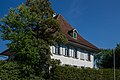
former Campagne in the municipality of Rubigen in the canton of Bern, Switzerland  | |||||
| Upload media | |||||
| Instance of | |||||
|---|---|---|---|---|---|
| Part of | |||||
| Location | Rubigen, Bern-Mittelland administrative district, Bernese Mittelland administrative region, Bern, Switzerland | ||||
| Street address |
| ||||
| Owned by | |||||
| Occupant | |||||
| Heritage designation | |||||
| Inception |
| ||||
| official website | |||||
 | |||||
Media in category "Schloss Rubigen"
The following 7 files are in this category, out of 7 total.
-
 Campagne Rubigen 1.jpg 1,024 × 683; 868 KB
-
 Campagne Rubigen 2.jpg 1,024 × 683; 827 KB
-
 Campagne Rubigen 4.jpg 1,024 × 683; 823 KB
-
 Campagne Rubigen 6.jpg 1,024 × 768; 1.02 MB
-
 Campagne Rubigen 9.jpg 1,024 × 683; 915 KB
-
 Rubigen Schloss 1.jpg 5,170 × 3,447; 15.9 MB
-
 Rubigen Schlosshof.jpg 5,623 × 3,749; 19.86 MB


