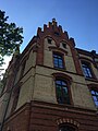
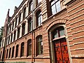
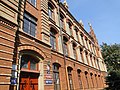
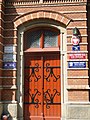
Category:School. Kraków ul. Dietla 70
Jump to navigation
Jump to search
| Object location | | View all coordinates using: OpenStreetMap |
|---|
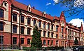
Polski: Zabytkowy budynek szkoły.
  | |||||
| Upload media | |||||
| Instance of | |||||
|---|---|---|---|---|---|
| Location | Kraków, Lesser Poland Voivodeship, Poland | ||||
| Street address |
| ||||
| Heritage designation |
| ||||
| Inception |
| ||||
| Significant event |
| ||||
 | |||||
| Address |
|
| Address |
|
| Address |
|
Media in category "School. Kraków ul. Dietla 70"
The following 16 files are in this category, out of 16 total.
-
 Kraków (28425728797).jpg 3,024 × 4,032; 2.84 MB
-
 Kraków, Szkoła Podstawowa nr 16 - fotopolska.eu (286681).jpg 1,400 × 940; 406 KB
-
 Kraków, Szkoła Podstawowa nr 16 - fotopolska.eu (286687).jpg 941 × 1,480; 376 KB
-
 Kraków, Szkoła Podstawowa nr 16 - fotopolska.eu (286690).jpg 1,400 × 1,331; 491 KB
-
 Primary School No. 16, Józefa Dietla 70, Kraków (1).jpg 3,988 × 2,784; 3.26 MB
-
 Primary School No. 16, Józefa Dietla 70, Kraków (2).jpg 3,956 × 2,960; 3.35 MB
-
 Szkola Dietla 2.jpg 3,456 × 2,592; 3.85 MB
-
 Szkola Dietla 3.jpg 2,592 × 3,456; 3.13 MB
-
 Szkola Dietla 4.jpg 3,456 × 2,592; 3.9 MB
-
 Szkola Dietla 5.jpg 3,456 × 2,592; 3.87 MB
-
 Szkola Dietla.jpg 2,592 × 3,456; 3.15 MB
-
 SzkołaMiejska-UlicaJózefaDietla70-POL, Kraków.jpg 6,000 × 3,700; 8.71 MB
-
 Ulica Józefa Dietla w Krakowie nr 70 1.jpg 1,280 × 960; 431 KB
-
 Ulica Józefa Dietla w Krakowie nr 70 2.jpg 960 × 1,280; 396 KB
-
 Ulica Józefa Dietla w Krakowie nr 70 3.jpg 960 × 1,280; 412 KB
-
 Ulica Józefa Dietla w Krakowie nr 70 4.jpg 960 × 1,280; 336 KB
.jpg)
.jpg)
.jpg)
.jpg)
.jpg)
.jpg)


