Category:Schulhaus (Dorfstrasse 81, Nennigkofen)
Jump to navigation
Jump to search
| Object location | | View all coordinates using: OpenStreetMap |
|---|
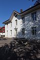
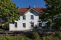
school building in Nennigkofen in the canton of Solothurn, Switzerland  | |||||
| Upload media | |||||
| Instance of | |||||
|---|---|---|---|---|---|
| Part of | |||||
| Location | Nennigkofen, Lüsslingen-Nennigkofen, Bucheggberg District, Bucheggberg-Wasseramt, Solothurn, Switzerland | ||||
| Street address |
| ||||
| Heritage designation | |||||
 | |||||
Media in category "Schulhaus (Dorfstrasse 81, Nennigkofen)"
The following 2 files are in this category, out of 2 total.
-
 2017-Nennigkofen-Schulhaus-HF.jpg 1,280 × 1,920; 2.25 MB
-
 2017-Nennigkofen-Schulhaus.jpg 1,920 × 1,280; 3.29 MB
