Category:Shaky Bridge
Jump to navigation
Jump to search
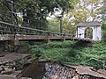
"The Shaky Bridge" near Trenton Water Filtration Plant on Route 29
| Object location | | View all coordinates using: OpenStreetMap |
|---|
created c.1800 by John A. Roebling as a demonstration project near Trenton Water Filtration Plant at the Calhoun Street Bridge (spans approx. 20 feet). [1]
OpenStreetmap Node :[2]
Bridgemeister id 303.[3] an Old Picture can be found.[4]
It was a Gift to the City of Trenton [5]
References[edit]
- ↑ NJ DEP - Historic Preservation Office New Jersey and National Registers of Historic Places 14. New Jersey Historic Preservation Office. Retrieved on 23 September 2016.
- ↑ Way: Shakey Bridge (377764544): demonstration project from John A. Roebling, built in the 1800. , accessdate: September 25, 2016
- ↑ Trenton, New Jersey, USA: Bridgemeister - Waste Weir (Shaky) - Trenton, New Jersey, USA, accessdate: September 25, 2016
- ↑ Macks Truck of Wisdom: The Shakey Bridge, Stacey Park, Trenton: old picture, accessdate: September 25, 2016
- ↑ Untitled Document: Additionally, some of these elements will be used at the 'Shaky Bridge' at the southern entrance. This scaled replica of a bridge built by the Roebling family was a gift to the City of Trenton and is currently undergoing renovation. The Roeblings are recognized as the engineers and builders of the Brooklyn Bridge, as well as many others and founded their wire rope plant in Trenton. , accessdate: September 25, 2016
Media in category "Shaky Bridge"
The following 16 files are in this category, out of 16 total.
-
 Trenton historic buildings- monuments (29273916784).jpg 4,032 × 3,024; 5.07 MB
-
 Trenton historic buildings- monuments (29274830493).jpg 4,032 × 3,024; 4.06 MB
-
 Trenton historic buildings- monuments (29274831483).jpg 4,032 × 3,024; 4.64 MB
-
 Trenton historic buildings- monuments (29606871200).jpg 4,032 × 3,024; 4.83 MB
-
 Trenton historic buildings- monuments (29606900340).jpg 4,032 × 3,024; 5.1 MB
-
 Trenton historic buildings- monuments (29787249962).jpg 4,032 × 3,024; 2.74 MB
-
 Trenton historic buildings- monuments (29787255082).jpg 4,032 × 3,024; 3.83 MB
-
 Trenton historic buildings- monuments (29787255092).jpg 4,032 × 3,024; 2.93 MB
-
 Trenton historic buildings- monuments (29787256532).jpg 4,032 × 3,024; 4.77 MB
-
 Trenton historic buildings- monuments (29817823601).jpg 4,032 × 3,024; 4.36 MB
-
 USA - NJ - Mercer - Trenton - Stacy Park - Shaky Bridge 1.JPG 5,184 × 3,456; 6.97 MB
-
 USA - NJ - Mercer - Trenton - Stacy Park - Shaky Bridge 2.JPG 5,184 × 3,456; 8.84 MB
-
 USA - NJ - Mercer - Trenton - Stacy Park - Shaky Bridge 3.JPG 5,184 × 3,456; 8.56 MB
-
 USA - NJ - Mercer - Trenton - Stacy Park - Shaky Bridge 4.JPG 5,184 × 3,456; 11.12 MB
-
 USA - NJ - Mercer - Trenton - Stacy Park - Shaky Bridge 5.JPG 5,184 × 3,456; 9.87 MB
-
 USA - NJ - Mercer - Trenton - Stacy Park - Shaky Bridge 6.JPG 5,184 × 3,456; 11.76 MB
.jpg)
.jpg)
.jpg)
.jpg)
.jpg)
.jpg)
.jpg)
.jpg)
.jpg)
.jpg)


