Category:Sheet 6 of the Turgot map of Paris
Jump to navigation
Jump to search

Media in category "Sheet 6 of the Turgot map of Paris"
The following 8 files are in this category, out of 8 total.
-
 Sheet 06. Paris. Plan de Turgot - David Rumsey.jpg 12,306 × 8,143; 35.75 MB
-
 Turgot map of Paris, sheet 6 - Norman B. Leventhal Map Center.tif 10,224 × 7,088; 207.37 MB
-
 Turgot map of Paris, sheet 6 - Norman B. Leventhal Map Center.jpg 8,950 × 5,730; 42.4 MB
-
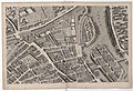 Turgot map of Paris (1739) - Sheet 06 - Bibliothèque nationale de France.jpg 10,222 × 6,951; 20.38 MB
-
 Turgot map of Paris - Sheet 06 - Bibliothèque nationale de France.jpg 9,169 × 6,394; 12.26 MB
-
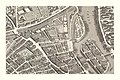 Turgot map of Paris - Sheet 06 - David Rumsey.jpg 21,000 × 14,000; 197.95 MB
-
 Turgot map of Paris - Sheet 06 - UWM Libraries.jpg 6,306 × 4,265; 5.82 MB
-
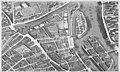 Turgot map Paris KU 06.jpg 4,800 × 2,900; 4.22 MB


_-_Sheet_06_-_Biblioth%C3%A8que_nationale_de_France.jpg)


Categories:
- Sheets of the Turgot map of Paris
- Historical images of Place des Vosges
- Old maps of Île Saint-Louis
- Île Louviers
- Historical images of Pont Marie
- Ancien pont de la Tournelle
- Bastille
- Port Saint-Bernard (Paris)
- Historical images of Église Saint-Paul-Saint-Louis
- Église Saint-Paul-des-champs
- Historical images of Temple du Marais
- Churches on Turgot map of Paris
- Pont de Grammont
- Arsenal de Paris
- Caserne des Mousquetaires noirs
- Hôtel de Mayenne
- Couvent des Célestins (Paris)
- Couvent de l'Ave-Maria
- Couvent des Minimes (Paris)
- Couvent Sainte-Catherine-du-Val-des-Écoliers