Category:Shiptonthorpe
Jump to navigation
Jump to search
English: Shiptonthorpe is a village and civil parish in the East Riding of Yorkshire, England. It is situated approximately 5 miles (8 km) south east of the market town of Pocklington and 2 miles (3.2 km) north west of the market town of Market Weighton. It lies on the north side of the A1079 road.
village and civil parish in East Yorkshire, England  | |||||
| Upload media | |||||
| Instance of | |||||
|---|---|---|---|---|---|
| Location | East Riding of Yorkshire, Yorkshire and the Humber, England | ||||
| Population |
| ||||
 | |||||
Subcategories
This category has the following 4 subcategories, out of 4 total.
A
- All Saints Church, Shiptonthorpe (16 F)
C
- The Crown, Shiptonthorpe (2 F)
L
S
- The Ship Inn, Shiptonthorpe (6 F)
Media in category "Shiptonthorpe"
The following 100 files are in this category, out of 100 total.
-
 A 614 Towthorpe Lane - geograph.org.uk - 2003734.jpg 800 × 600; 259 KB
-
 A1079 toward Market Weighton from Shiptonthorpe - geograph.org.uk - 6556801.jpg 4,344 × 3,229; 1.7 MB
-
 A614 at Shiptonthorpe village boundary - geograph.org.uk - 5922769.jpg 1,024 × 758; 111 KB
-
 A614 near Low Grange Farm - geograph.org.uk - 5922767.jpg 1,024 × 733; 109 KB
-
 Along Harswell Lane - geograph.org.uk - 5102199.jpg 640 × 427; 137 KB
-
 Along Harswell Lane to Shiptonthorpe - geograph.org.uk - 5102201.jpg 640 × 427; 141 KB
-
 Approaching Shiptonthorpe - geograph.org.uk - 5102196.jpg 640 × 427; 115 KB
-
 Approaching Shiptonthorpe roundabout A1079 - geograph.org.uk - 3166233.jpg 2,560 × 1,920; 2.04 MB
-
 Back Lane - geograph.org.uk - 5102197.jpg 640 × 427; 114 KB
-
 BP at Shipton Bridge from Langlands Garden Centre - geograph.org.uk - 4848257.jpg 3,072 × 1,728; 1.72 MB
-
 BP garage - geograph.org.uk - 1989191.jpg 800 × 600; 225 KB
-
 Cleaving Cottage, Shiptonthorpe - geograph.org.uk - 4131386.jpg 1,600 × 1,064; 836 KB
-
 Cottage on Back Lane, Shiptonthorpe - geograph.org.uk - 179593.jpg 640 × 480; 77 KB
-
 Dusused pit off Harswell Lane - geograph.org.uk - 3982415.jpg 1,024 × 768; 193 KB
-
 Entering Shiptonthorpe - geograph.org.uk - 3166245.jpg 2,560 × 1,920; 2.05 MB
-

-
 Eventually To Bridlington. - geograph.org.uk - 302512.jpg 634 × 479; 97 KB
-
 Farm Buildings Shiptonthorpe - geograph.org.uk - 1153326.jpg 640 × 480; 76 KB
-
 Farm machinery for sale - geograph.org.uk - 4073296.jpg 1,600 × 1,064; 783 KB
-
 Farm Shop - geograph.org.uk - 827529.jpg 640 × 409; 53 KB
-
 Farm track off Harswell Lane - geograph.org.uk - 2034899.jpg 640 × 480; 56 KB
-
 Farmland near Shipton Grange - geograph.org.uk - 2035104.jpg 640 × 480; 82 KB
-
 Farmland south west of Shiptonthorpe - geograph.org.uk - 2034978.jpg 640 × 480; 72 KB
-
 Farmtrack off Harswell Lane - geograph.org.uk - 4073463.jpg 1,600 × 1,064; 650 KB
-
 Field by A614 - geograph.org.uk - 5435816.jpg 640 × 426; 52 KB
-
 Fields near Shiptonthorpe - geograph.org.uk - 5188166.jpg 640 × 480; 167 KB
-
 Flat fields and Grange Farm, Shipton Common - geograph.org.uk - 5729122.jpg 1,024 × 768; 134 KB
-
 Garden Centre at Shiptonthorpe - geograph.org.uk - 9215.jpg 640 × 480; 65 KB
-
 Garden Centre, Shiptonthorpe - geograph.org.uk - 5187068.jpg 640 × 427; 144 KB
-
 Garrick Farm - geograph.org.uk - 5348187.jpg 1,024 × 768; 235 KB
-
 Gate in Hedge - geograph.org.uk - 1152530.jpg 640 × 480; 107 KB
-
 Georgian Post Box on Town Street, Shiptonthorpe - geograph.org.uk - 5708974.jpg 1,065 × 1,600; 657 KB
-
 Hardacres off Harswell Lane - geograph.org.uk - 4073335.jpg 1,600 × 1,128; 461 KB
-
 Harswell Lane - geograph.org.uk - 5102198.jpg 640 × 427; 123 KB
-
 Harswell Lane - geograph.org.uk - 6530573.jpg 1,024 × 768; 119 KB
-
 Harswell Lane - geograph.org.uk - 6530574.jpg 1,024 × 768; 209 KB
-
 Harswell Lane toward Shiptonthorpe - geograph.org.uk - 5315360.jpg 2,304 × 1,728; 1.05 MB
-
 Harswell Lane towards Brouncey - geograph.org.uk - 4073471.jpg 1,600 × 1,064; 926 KB
-
 Harswell Lane towards Brouncey - geograph.org.uk - 4073472.jpg 1,600 × 1,064; 767 KB
-
 Harswell Lane towards Brouncey - geograph.org.uk - 4131443.jpg 1,600 × 1,064; 480 KB
-
 Harswell Lane towards Brouncey Farm - geograph.org.uk - 2034990.jpg 640 × 480; 139 KB
-
 Harswell Lane towards Harswell - geograph.org.uk - 4073373.jpg 1,600 × 1,064; 860 KB
-
 Harswell Lane towards Harswell - geograph.org.uk - 4073376.jpg 1,600 × 1,064; 805 KB
-
 Harswell Lane towards Harswell - geograph.org.uk - 4073384.jpg 1,600 × 1,064; 1.05 MB
-
 Harswell Lane with the sun on our backs - geograph.org.uk - 5315365.jpg 2,258 × 1,666; 1.62 MB
-
 Harswell Lane, near Shiptonthorpe - geograph.org.uk - 5188172.jpg 480 × 640; 174 KB
-
 Harswell Lane, Shiptonthorpe - geograph.org.uk - 4073309.jpg 1,600 × 1,064; 857 KB
-
 Harswell Lane, Shiptonthorpe - geograph.org.uk - 4073317.jpg 1,600 × 1,064; 862 KB
-
 Harswell Lane, Shiptonthorpe - geograph.org.uk - 4073322.jpg 1,600 × 1,064; 578 KB
-
 Harswell Lane, Shiptonthorpe - geograph.org.uk - 4073327.jpg 1,600 × 1,064; 623 KB
-
 Hen house at Manor Farm - geograph.org.uk - 4995260.jpg 1,500 × 1,000; 1.57 MB
-
 HGV, A614 - geograph.org.uk - 5435815.jpg 640 × 482; 54 KB
-
 House on York Road, Shiptonthorpe - geograph.org.uk - 4131402.jpg 1,600 × 1,109; 656 KB
-
 Houses on York Road, Shiptonthorpe - geograph.org.uk - 4131419.jpg 1,600 × 1,064; 735 KB
-
 Looking towards Shiptonthorpe - geograph.org.uk - 76913.jpg 640 × 393; 104 KB
-
 Manor Farm A1079 - geograph.org.uk - 236866.jpg 640 × 426; 129 KB
-
 Methodist Church Town Street Shiptonthorpe - geograph.org.uk - 5314158.jpg 2,292 × 1,714; 1.34 MB
-

-
 New 24 hour McDonald's near Shiptonthorpe - geograph.org.uk - 3746191.jpg 1,024 × 681; 217 KB
-
 New road layout at Shiptonthorpe roundabout - geograph.org.uk - 6556797.jpg 4,608 × 3,456; 2.66 MB
-
 Newlands Farm - geograph.org.uk - 302518.jpg 640 × 480; 93 KB
-
 Northwest from Shiptonthorpe on the A1079 - geograph.org.uk - 3166256.jpg 1,750 × 1,230; 450 KB
-
 Old valve cover - geograph.org.uk - 5350322.jpg 1,024 × 768; 343 KB
-
 Petrol Station A1079 Shiptonthorpe - geograph.org.uk - 236868.jpg 640 × 426; 118 KB
-
 Pond or Flood^ - geograph.org.uk - 1730716.jpg 3,648 × 2,736; 2.9 MB
-
 Power lines near Brouncey Farm - geograph.org.uk - 2034985.jpg 640 × 480; 61 KB
-
 Pylons - geograph.org.uk - 5435820.jpg 640 × 426; 35 KB
-
 Pylons beside Harswell Lane - geograph.org.uk - 5102223.jpg 640 × 427; 122 KB
-
 Pylons heading east from Harswell Lane - geograph.org.uk - 4073484.jpg 1,600 × 1,064; 902 KB
-
 Pylons near A614 - geograph.org.uk - 5435818.jpg 640 × 426; 35 KB
-
 Road towards Garrick Farm - geograph.org.uk - 6530586.jpg 1,024 × 768; 135 KB
-
 Sheds off Harswell Lane - geograph.org.uk - 3982429.jpg 1,024 × 768; 184 KB
-
 Shipton Grange - geograph.org.uk - 2035097.jpg 640 × 480; 75 KB
-
 Shipton Grange - geograph.org.uk - 84554.jpg 640 × 480; 65 KB
-
 Shipton Grange Farm - geograph.org.uk - 2198107.jpg 800 × 600; 166 KB
-
 Shipton Lane - geograph.org.uk - 5350451.jpg 1,024 × 768; 200 KB
-
 Shipton Lane - geograph.org.uk - 6530576.jpg 1,024 × 768; 150 KB
-
 Shipton Lane towards Shiptonthorpe - geograph.org.uk - 2198110.jpg 800 × 600; 204 KB
-
 Shiptonthorpe - Town Street - geograph.org.uk - 5188162.jpg 640 × 473; 148 KB
-
 Shiptonthorpe magnolias - geograph.org.uk - 5348169.jpg 1,024 × 742; 202 KB
-
 Shiptonthorpe magnolias 2 - geograph.org.uk - 5348180.jpg 1,024 × 768; 264 KB
-
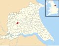 Shiptonthorpe UK parish locator map.svg 1,425 × 1,107; 1.68 MB
-
 Shiptonthorpe Village Hall - geograph.org.uk - 6530575.jpg 1,024 × 768; 247 KB
-

-
 Southview Farmhouse, York Road, Shiptonthorpe - geograph.org.uk - 4131414.jpg 1,600 × 1,064; 649 KB
-
 The A1079, York Road, Shiptonthorpe - geograph.org.uk - 4073302.jpg 1,600 × 1,064; 629 KB
-
 The A614 - geograph.org.uk - 302526.jpg 640 × 480; 109 KB
-
 The Lodge, Town Street - geograph.org.uk - 1631732.jpg 640 × 480; 113 KB
-
 The New Country House - geograph.org.uk - 302532.jpg 640 × 480; 101 KB
-
 The new road layout on the A1079 at Shiptonthorpe roundabout - geograph.org.uk - 6556787.jpg 3,670 × 2,753; 1.19 MB
-
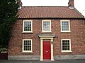
 The Old Post Office - geograph.org.uk - 5708971.jpg 1,600 × 1,065; 618 KB
-
 Town Street, Shiptonthorpe - geograph.org.uk - 5188152.jpg 640 × 480; 148 KB
-
 Town Street, Shiptonthorpe - geograph.org.uk - 5350251.jpg 1,024 × 737; 142 KB
-
 Town Street, Shiptonthorpe - geograph.org.uk - 5350286.jpg 1,024 × 768; 168 KB
-
 Track off Shipton Lane - geograph.org.uk - 5341387.jpg 1,024 × 768; 233 KB
-
 Track to Low Grange - geograph.org.uk - 2035107.jpg 640 × 512; 39 KB
-
 View towards Langlands Nurseries - geograph.org.uk - 5350449.jpg 1,024 × 768; 219 KB
-
 View towards Londesborough - geograph.org.uk - 5350291.jpg 1,024 × 768; 138 KB
-
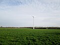 Wind turbine at North Grange Farm - geograph.org.uk - 5314137.jpg 2,302 × 1,724; 1.34 MB
-
 Yellow Tour de France bike in Shiptonthorpe - geograph.org.uk - 4073284.jpg 1,600 × 1,064; 816 KB


