Category:Shottermill
Jump to navigation
Jump to search
English: Shottermill is a village in Surrey, straddling the border with West Sussex, England near Haslemere. The village is part of the census area Linchmere which has a population of 2,225.
village straddling the Surrey-Sussex border  | |||||
| Upload media | |||||
| Instance of |
| ||||
|---|---|---|---|---|---|
| Location | |||||
 | |||||
Subcategories
This category has the following 16 subcategories, out of 16 total.
B
- Border Road, Shottermill (1 F)
- Buffbeards Lane, Shottermill (1 F)
C
- Church Road, Shottermill (6 F)
H
- Hindhead Road, Haslemere (25 F)
J
L
- Lion Green, Haslemere (3 F)
- Liphook Road, Haslemere (24 F)
M
- Haslemere Methodist Church (9 F)
- The Mill Tavern, Shottermill (10 F)
S
- Shottermill Road, Haslemere (8 F)
- Shottermill War Memorial (5 F)
V
- Vicarage Lane, Haslemere (5 F)
Media in category "Shottermill"
The following 64 files are in this category, out of 64 total.
-
 Air raid shelter, Shottermill 01.jpg 4,128 × 3,096; 5.13 MB
-
 Air raid shelter, Shottermill 02.jpg 4,128 × 3,096; 9.62 MB
-
 Air raid shelter, Shottermill.jpg 4,128 × 3,096; 6.44 MB
-
 Autumn trees, Polecat, Shottermill 2.jpg 5,152 × 3,864; 4.53 MB
-
 Autumn trees, Polecat, Shottermill.jpg 5,152 × 3,864; 13.28 MB
-
 Blackberries and barbed wire.jpg 4,128 × 3,096; 4.34 MB
-
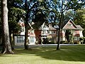 Branksome Conference and Training Centre - geograph.org.uk - 59530.jpg 566 × 425; 160 KB
-
 Bridge over the Wey near Shottermill - geograph.org.uk - 3949453.jpg 2,048 × 1,536; 1.02 MB
-
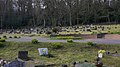 Burial ground at Shottermill - geograph.org.uk - 1228085.jpg 640 × 360; 78 KB
-
 Bus stop at Shottermill, Surrey - geograph.org.uk - 2025596.jpg 1,024 × 752; 293 KB
-
 Empty petrol station during the September 2021 petrol-buying panic, Shottermill.jpg 4,000 × 3,000; 3.93 MB
-
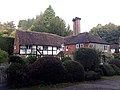
 Fleur De Lys Old Bramhyl, Shottermill 01.jpg 4,128 × 3,096; 5.68 MB
-
 Fleur De Lys Old Bramhyl, Shottermill 02.jpg 4,128 × 3,096; 6.37 MB
-
 Fleur De Lys Old Bramhyl, Shottermill 03.jpg 4,128 × 3,096; 6.53 MB
-
 Fleur De Lys Old Bramhyl, Shottermill 04.jpg 4,128 × 3,096; 6.88 MB
-
 Fungi at Springhead, Shottermill 01.jpg 2,576 × 1,932; 1.02 MB
-
 Fungi at Springhead, Shottermill 02.jpg 4,000 × 3,000; 4.67 MB
-
 Fungi at Springhead, Shottermill 03.jpg 2,576 × 1,932; 1.11 MB
-
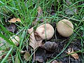 Fungi at Springhead, Shottermill 04.jpg 4,000 × 3,000; 4.41 MB
-
 Fungi at Springhead, Shottermill 05.jpg 2,576 × 1,932; 1.32 MB
-
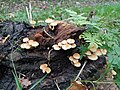 Fungi at Springhead, Shottermill 06.jpg 4,000 × 3,000; 3.35 MB
-
 Fungi at Springhead, Shottermill 07.jpg 4,000 × 3,000; 3.98 MB
-
 Fungi at Springhead, Shottermill 08.jpg 1,932 × 2,576; 995 KB
-
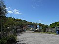 Haslemere Sewage Treatment Works.jpg 5,152 × 3,864; 4.4 MB
-
 Ivy tendril, Shottermill.jpg 1,031 × 1,704; 1,007 KB
-
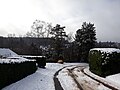
 Mead Way, Shottermill, after snowfall.jpg 4,128 × 3,096; 6.54 MB
-
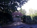
 Mill Cottage, Camelsdale Road, Shottermill (June 2015).jpg 2,400 × 1,400; 801 KB
-
 Old mill bridge, Hammer.jpg 5,152 × 3,864; 4.51 MB
-
 Polecat Copse NT sign, Haslemere.jpg 2,112 × 2,816; 1.47 MB
-
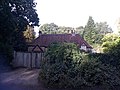
 Pond Cottage, Camelsdale Road, Shottermill (NHLE Code 1025906) (June 2015).jpg 2,400 × 1,800; 731 KB
-
 Shottermill - geograph.org.uk - 3743.jpg 640 × 405; 39 KB
-
 Shottermill during COVID-19 pandemic lockdown 04.jpg 4,128 × 3,096; 4.8 MB
-
 Shottermill during COVID-19 pandemic lockdown 05.jpg 4,128 × 3,096; 5.71 MB
-
 Shottermill during COVID-19 pandemic lockdown 06.jpg 4,128 × 3,096; 4.89 MB
-
 Shottermill during COVID-19 pandemic lockdown 08.jpg 4,128 × 3,096; 5.56 MB
-
 Shottermill during COVID-19 pandemic lockdown 11.jpg 3,096 × 4,128; 3.13 MB
-
 Shottermill during COVID-19 pandemic lockdown 12.jpg 3,096 × 4,128; 3.38 MB
-
 Shottermill French Market during COVID-19 pandemic 01.jpg 4,128 × 3,096; 5.76 MB
-
 Shottermill French Market during COVID-19 pandemic 02.jpg 3,096 × 4,128; 6.82 MB
-
 Shottermill French Market during COVID-19 pandemic 03.jpg 4,128 × 3,096; 5.73 MB
-
 Shottermill Pond, Camelsdale Road, Shottermill (June 2015).jpg 2,592 × 1,944; 1,007 KB
-
 Shottermill War Memorial, Camelsdale Road, Shottermill (June 2015).jpg 1,400 × 1,200; 275 KB
-
 Social distancing during COVID-19 pandemic, Haslemere 01.jpg 4,128 × 3,096; 4.56 MB
-
 Social distancing during COVID-19 pandemic, Haslemere 02.jpg 4,128 × 3,096; 5 MB
-
 Social distancing during COVID-19 pandemic, Haslemere 03.jpg 4,128 × 3,096; 4.66 MB
-
 Springhead Barn, Shottermill 01.jpg 4,128 × 3,096; 5.47 MB
-
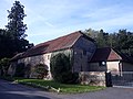 Springhead Barn, Shottermill 02.jpg 4,128 × 3,096; 5.73 MB
-
 Springhead, Shottermill 01.jpg 4,128 × 3,096; 6.37 MB
-
 Springhead, Shottermill 02.jpg 4,128 × 3,096; 6.06 MB
-
 Storm Ophelia outlier, Shottermill, Surrey.jpg 3,264 × 2,448; 2.1 MB
-
 Sturt Farm, Shottermill 04.jpg 4,128 × 3,096; 6.21 MB
-
 Sturt Farm, Shottermill 06.jpg 4,128 × 3,096; 6 MB
-
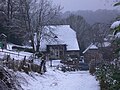
 Sturt Farm, Shottermill, after snowfall 01.jpg 4,128 × 3,096; 3.69 MB
-
 Sturt Farm, Shottermill, after snowfall 02.jpg 4,128 × 3,096; 7.28 MB
-
 Sturt Farm, Shottermill, after snowfall 03.jpg 4,128 × 3,096; 6.67 MB
-
 Sun Brow, Haslemere, in snow 01.jpg 4,128 × 3,096; 8.4 MB
-
 Sun Brow, Haslemere, in snow 02.jpg 4,128 × 3,096; 4.95 MB
-
 Sun Brow, Haslemere, in snow 03.jpg 4,128 × 3,096; 3.43 MB
-
 The approach to Sturt Farm - geograph.org.uk - 1671136.jpg 800 × 600; 156 KB
-
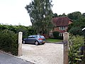
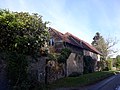
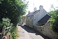 The Cottage, Critchmere Hill - geograph.org.uk - 2085757.jpg 640 × 430; 95 KB
-
 The Dene, Shottermill 01.jpg 4,128 × 3,096; 4.98 MB
-
 The Dene, Shottermill 02.jpg 4,128 × 3,096; 5.81 MB
-
 The Dene, Shottermill 03.jpg 4,128 × 3,096; 6.6 MB
-
 Utility units at Haslemere Leisure Centre.jpg 4,000 × 3,000; 3.65 MB


.jpg)


_(June_2015).jpg)


.jpg)
.jpg)


