Category:Sint-Brigidakerk (Geldrop)
Jump to navigation
Jump to search
| Object location | | View all coordinates using: OpenStreetMap |
|---|
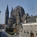
church building in Geldrop-Mierlo, Netherlands _P1060767.JPG) | |||||
| Upload media | |||||
| Instance of | |||||
|---|---|---|---|---|---|
| Location | Geldrop, North Brabant, Netherlands | ||||
| Street address |
| ||||
| Located on street |
| ||||
| Architect | |||||
| Heritage designation |
| ||||
| Inception |
| ||||
| Religion or worldview | |||||
 | |||||
|
This is a category about rijksmonument number 16034
|
| Address |
|
Media in category "Sint-Brigidakerk (Geldrop)"
The following 39 files are in this category, out of 39 total.
-
 16034 Sint-Brigidakerk 2.jpg 4,187 × 4,735; 13.04 MB
-
 16034 Sint-Brigidakerk 3.jpg 2,500 × 1,703; 3.65 MB
-
 16034 Sint-Brigidakerk 4.jpg 4,613 × 3,209; 8.68 MB
-
 16034 Sint-Brigidakerk 5.jpg 4,385 × 5,661; 17.47 MB
-
 16034 Sint-Brigidakerk.jpg 3,456 × 5,184; 13.71 MB
-
 Exterieur noord-oost zijde - Geldrop - 20076712 - RCE.jpg 1,200 × 967; 164 KB
-
 Exterieur noord-oost zijde - Geldrop - 20363712 - RCE.jpg 1,200 × 1,196; 247 KB
-
 Exterieur noord-west zijde - Geldrop - 20076710 - RCE.jpg 947 × 1,200; 179 KB
-
 Exterieur noord-west zijde - Geldrop - 20076714 - RCE.jpg 952 × 1,200; 177 KB
-
 Exterieur uit het zuid-westen - Geldrop - 20076711 - RCE.jpg 952 × 1,200; 218 KB
-
 Exterieur uit het zuid-westen - Geldrop - 20076713 - RCE.jpg 946 × 1,200; 219 KB
-
 Geldrop - H Brigidakerk.jpg 3,456 × 5,184; 14.69 MB
-
 Geldrop St. Brigidakerk (1).jpg 2,448 × 3,264; 2.39 MB
-
 Geldrop St. Brigidakerk (2).jpg 3,264 × 2,448; 2.3 MB
-
 Interieur naar het zuid-westen - Geldrop - 20076715 - RCE.jpg 1,200 × 958; 294 KB
-
 Interieur, aanzicht orgel, orgelnummer 488 - Geldrop - 20417786 - RCE.jpg 806 × 1,200; 238 KB
-
 Interieur, overzicht naar het oosten gezien - Geldrop - 20379778 - RCE.jpg 1,200 × 1,198; 265 KB
-
 Interieur, zicht op altaar - Geldrop - 20363713 - RCE.jpg 1,200 × 1,173; 260 KB
-
 Kermis Geldrop P1060766.JPG 3,264 × 2,448; 3.74 MB
-
 Overzicht van de zuid-oostgevel - Geldrop - 20379777 - RCE.jpg 1,196 × 1,200; 247 KB
-
 Overzicht van de zuid-westgevel met dubbel torenfront - Geldrop - 20379776 - RCE.jpg 1,189 × 1,200; 228 KB
-
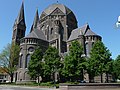
 Overzicht zuidwestgevel met kerktorens - Geldrop - 20347536 - RCE.jpg 1,191 × 1,200; 429 KB
-
 Overzicht zuidwestgevel met kerktorens - Geldrop - 20348747 - RCE.jpg 956 × 1,200; 295 KB
-
 Sint-Brigidakerk (Geldrop) P1060743.JPG 2,448 × 3,264; 3.75 MB
-
 Sint-Brigidakerk (Geldrop) P1060744.JPG 2,448 × 3,264; 3.81 MB
-
 Sint-Brigidakerk (Geldrop) P1060745.JPG 2,448 × 3,264; 3.68 MB
-
 Sint-Brigidakerk (Geldrop) P1060746.JPG 2,448 × 3,264; 3.73 MB
-
 Sint-Brigidakerk (Geldrop) P1060747.JPG 2,448 × 3,264; 3.82 MB
-
 Sint-Brigidakerk (Geldrop) P1060748.JPG 2,448 × 3,264; 3.61 MB
-
 Sint-Brigidakerk (Geldrop) P1060749.JPG 2,448 × 3,264; 3.67 MB
-
 Sint-Brigidakerk (Geldrop) P1060751.JPG 2,448 × 3,264; 3.86 MB
-
 Sint-Brigidakerk (Geldrop) P1060752.JPG 3,264 × 2,448; 3.83 MB
-
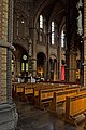
 Sint-Brigidakerk (Geldrop) P1060767.JPG 3,264 × 2,448; 3.82 MB
-
 T.T RK Kerk H. Brigida Geldrop (1).JPG 2,048 × 3,072; 1.22 MB
-
 T.T RK Kerk H. Brigida Geldrop (2).JPG 2,048 × 3,072; 1.18 MB
-
 T.T RK Kerk H. Brigida Geldrop (3).JPG 3,072 × 2,048; 1.4 MB
-
 T.T RK Kerk H. Brigida Geldrop (4).JPG 2,048 × 3,072; 1.27 MB
-
 T.T RK Kerk H. Brigida Geldrop (5).JPG 2,048 × 3,072; 1.02 MB
-
 T.T RK Kerk H. Brigida Geldrop (6).JPG 2,048 × 3,072; 1.12 MB


.jpg)
.jpg)


_P1060743.JPG)
_P1060744.JPG)
_P1060745.JPG)
_P1060746.JPG)
_P1060747.JPG)
_P1060748.JPG)
_P1060749.JPG)
_P1060751.JPG)
_P1060752.JPG)
.JPG)
.JPG)
.JPG)
.JPG)
.JPG)
.JPG)