Category:Sint-Catharinakerk (Wachtebeke)
Jump to navigation
Jump to search
| Object location | | View all coordinates using: OpenStreetMap |
|---|
|
This is a category about Beschermd erfgoed number 9248
|
|
This is a category about onroerend erfgoed number 34347
|
church in Wachtebeke, Belgium  | |||||
| Upload media | |||||
| Instance of | |||||
|---|---|---|---|---|---|
| Dedicated to | |||||
| Location | Wachtebeke, Arrondissement of Ghent, East Flanders, Flemish Region, Belgium | ||||
| Diocese | |||||
| Heritage designation | |||||
 | |||||
Media in category "Sint-Catharinakerk (Wachtebeke)"
The following 12 files are in this category, out of 12 total.
-
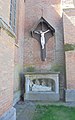 Heilig Kruisbeeld - Kerk - Wachtebeke.jpg 2,288 × 3,648; 2.02 MB
-
 Kerkwabeke biechtstoel.jpg 1,627 × 2,500; 1.9 MB
-
 Kerkwabeke doopkapel.jpg 1,660 × 2,500; 1.95 MB
-
 Kerkwabeke glasraam.jpg 1,660 × 2,500; 2.59 MB
-
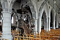 Kerkwabeke interieur.jpg 2,500 × 1,660; 2.11 MB
-
 Kerkwabeke kruisbeeld.jpg 1,660 × 2,500; 1.75 MB
-
 Kerkwabeke linkeraltaar.jpg 1,660 × 2,500; 1.99 MB
-
 Kerkwabeke middenaltaar.jpg 1,660 × 2,500; 1.65 MB
-
 Kerkwabeke rechteraltaar.jpg 1,660 × 2,500; 1.94 MB
-
 Kerkwabeke terracotta.jpg 2,500 × 1,185; 1.25 MB
-
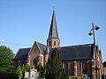 Wachtebeke - Sint-Catharinakerk 1.jpg 2,304 × 1,728; 1.59 MB
-
 Wachtebeke - Sint-Catharinakerk 2.jpg 2,304 × 1,728; 1.81 MB


