Category:Sint-Jozefkerk (Wezel, Belgium)
Jump to navigation
Jump to search
| Object location | | View all coordinates using: OpenStreetMap |
|---|
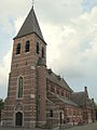
Nederlands: Afbeeldingen van de Sint-Jozefkerk (Wezel, Belgium), Sint-Jozefslaan, 2400 Mol, België. Gelegen in Wezel, Belgium behorende tot de gemeenten Mol (België) en Balen in de provincie Antwerpen in het noorden van België
|
This is a category about onroerend erfgoed number 52936
|
church in Mol-Wezel, Belgium  | |||||
| Upload media | |||||
| Instance of | |||||
|---|---|---|---|---|---|
| Dedicated to | |||||
| Location | Wezel, Balen, Arrondissement of Turnhout, Province of Antwerp, Flemish Region, Belgium | ||||
| Architectural style | |||||
| Diocese | |||||
| Architect | |||||
| Heritage designation | |||||
| Inception |
| ||||
 | |||||
Nederlands: Sint-Jozefskerk (Wezel), Wezel (België), Mol (België), Balen (België), provincie Antwerpen, België
Media in category "Sint-Jozefkerk (Wezel, Belgium)"
The following 2 files are in this category, out of 2 total.
-
 Mol - Sint-Jozefkerk.jpg 1,536 × 2,048; 1.02 MB
-
 Parochiekerk Sint-Jozef.jpg 2,657 × 1,831; 2.34 MB
