Category:Sint-Monulphus en Gondulphuskerk (Sint-Huibrechts-Lille)
Jump to navigation
Jump to search
| Object location | | View all coordinates using: OpenStreetMap |
|---|
|
This is a category about onroerend erfgoed number 80301
|
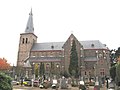
church in Sint-Huibrechts-Lille, Belgium  | |||||
| Upload media | |||||
| Instance of | |||||
|---|---|---|---|---|---|
| Dedicated to | |||||
| Location | Sint-Huibrechts-Lille, Pelt, Arrondissement of Maaseik, Limburg, Flemish Region, Belgium | ||||
| Diocese | |||||
 | |||||
Media in category "Sint-Monulphus en Gondulphuskerk (Sint-Huibrechts-Lille)"
The following 5 files are in this category, out of 5 total.
-
 De kerk van Sint-Huibrechts-Lille.JPG 1,712 × 2,288; 675 KB
-

-
 De St.-Monulphus en Gondulphuskerk van St-Huibrechts-Lille - 371342 - onroerenderfgoed.jpg 2,418 × 1,648; 3.54 MB
-
 Sint Huibrechts-Lille, Sint Mondulphus en Gondulphuskerk foto1 2009-08-31 17.02.JPG 2,564 × 3,419; 4.94 MB
-
 Sint-Huibrechts-Lille - Sint-Monulphus en Gondulphuskerk.jpg 2,048 × 1,536; 1.02 MB


