Category:Sint-Remigiuskerk (Baarle-Hertog)
Jump to navigation
Jump to search
| Object location | | View all coordinates using: OpenStreetMap |
|---|
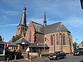
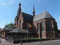
Nederlands: Afbeeldingen van de Sint-Remigiuskerk, Kerkplein 8, 2387 Baarle-Hertog, België. Gelegen in de gemeente Baarle-Hertog in de provincie Antwerpen in het noorden van België. De Remigiuskerk is gedeeltelijk vernield op 2/10/1944
|
This is a category about Beschermd erfgoed number 4191
|
|
This is a category about onroerend erfgoed number 46381
|
church in Baarle-Hertog, Belgium  | |||||
| Upload media | |||||
| Instance of | |||||
|---|---|---|---|---|---|
| Named after | |||||
| Dedicated to | |||||
| Location | Baarle, Baarle-Hertog, Arrondissement of Turnhout, Province of Antwerp, Flemish Region, Belgium | ||||
| Architectural style | |||||
| Diocese | |||||
| Heritage designation | |||||
| Inception |
| ||||
 | |||||
Subcategories
This category has only the following subcategory.
Media in category "Sint-Remigiuskerk (Baarle-Hertog)"
The following 10 files are in this category, out of 10 total.
-
 46381 Parochiekerk Sint-Remigius.jpg 1,779 × 3,000; 4.64 MB
-
 Baarle Hertog, Sint Remigiuskerk foto2 2010-10-03 11.50.JPG 3,456 × 2,592; 1.02 MB
-
 De grens in zicht, hier begon het - panoramio.jpg 3,072 × 2,304; 5.44 MB
-
 Exterieur vanuit het noorden na de restauratie - Baarle-Hertog - 20026855 - RCE.jpg 1,200 × 1,191; 204 KB
-
 Het raadhuis of stadhuis en de St, SFA022829259.jpg 2,609 × 3,539; 1.15 MB
-
 P1020708Sint-Remigiuskerk.JPG 3,264 × 2,448; 3.13 MB
-
 P1070678Sint-Remigiuskerk.JPG 3,264 × 2,448; 3.67 MB
-
 Sint-Remigiuskerk Baarle-Hertog.jpg 1,024 × 683; 352 KB
-
 Sint-Remigiuskerk, Baarle-Hertog.jpg 2,855 × 3,910; 1.32 MB
-
 Sint-Remigiuskerk.jpg 2,304 × 3,072; 1.21 MB


