Category:Sint-Servatiuskerk (Diepenbeek)
Jump to navigation
Jump to search
|
This is a category about onroerend erfgoed number 83670
|
| Object location | | View all coordinates using: OpenStreetMap |
|---|
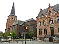
church in Diepenbeek, Belgium   | |||||
| Upload media | |||||
| Instance of | |||||
|---|---|---|---|---|---|
| Named after | |||||
| Dedicated to | |||||
| Location | Diepenbeek, Arrondissement of Hasselt, Limburg, Flemish Region, Belgium | ||||
| Architectural style | |||||
| Diocese | |||||
| Heritage designation |
| ||||
 | |||||
English: Tower about 1500, nave since 1777
Subcategories
This category has only the following subcategory.
S
Media in category "Sint-Servatiuskerk (Diepenbeek)"
The following 10 files are in this category, out of 10 total.
-
 Diepenbeek Marktplein zonder nummer - 139678 - onroerenderfgoed.jpg 468 × 591; 106 KB
-
 Diepenbeek Marktplein zonder nummer - 166254 - onroerenderfgoed.jpg 1,076 × 1,500; 265 KB
-
 Diepenbeek Marktplein zonder nummer - 166255 - onroerenderfgoed.jpg 1,051 × 1,500; 257 KB
-
 Diepenbeek Marktplein zonder nummer Interieur - 166256 - onroerenderfgoed.jpg 1,500 × 1,063; 263 KB
-
 Diepenbeek Marktplein zonder nummer Interieur - 166257 - onroerenderfgoed.jpg 1,054 × 1,500; 255 KB
-
 Diepenbeek Sint-Servatius 13.JPG 3,723 × 2,483; 7.61 MB
-
 Diepenbeek Sint-Servatius 14.JPG 2,456 × 3,671; 7.85 MB
-
 Diepenbeek Sint-Servatius 3.JPG 2,424 × 3,595; 7.65 MB
-
 Diepenbeek6.jpg 1,200 × 1,600; 258 KB
-
 Servatiusdiepenbeek.jpg 1,600 × 1,200; 583 KB


