Category:Sint Jacobstraat 9, Goes
Jump to navigation
Jump to search
| Object location | | View all coordinates using: OpenStreetMap |
|---|
 | |||||
| Upload media | |||||
| Instance of |
| ||||
|---|---|---|---|---|---|
| Location | Goes, Zeeland, Netherlands | ||||
| Street address |
| ||||
| Located on street | |||||
| Heritage designation |
| ||||
 | |||||
|
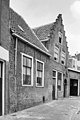
This is a category about rijksmonument number 16320
|
| Address |
|
Media in category "Sint Jacobstraat 9, Goes"
The following 6 files are in this category, out of 6 total.
-
 En lager, overzicht - Goes - 20079620 - RCE.jpg 1,198 × 1,200; 349 KB
-
 Goes 08821.jpg 281 × 500; 142 KB
-
 Goes St Jacobstraat 9.jpg 1,712 × 2,288; 781 KB
-
 Poortje - Goes - 20079590 - RCE.jpg 801 × 1,200; 257 KB
-
 Voorgevel - Goes - 20079588 - RCE.jpg 955 × 1,200; 241 KB
-
 Voorgevel - Goes - 20079589 - RCE.jpg 801 × 1,200; 238 KB


