Category:Sint Victor (Apeldoorn)
Jump to navigation
Jump to search
| Object location | | View all coordinates using: OpenStreetMap |
|---|
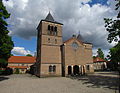
Nederlands: Apeldoorn, Jachtlaan 189 - Victorkerk - anno 1955 - Van oorsprong een rooms-katholieke kerk - buiten gebruik gesteld in 2013 als rooms-katholieke kerk - In 2015 aangekocht door de Hersteld Hervormde Gemeente Apeldoorn - Draagt sinds die tijd de naam Victorkerk
|
This is a category about a municipal monument in Apeldoorn with number wikinr 259 |
Media in category "Sint Victor (Apeldoorn)"
The following 5 files are in this category, out of 5 total.
-
 Apeldoorn, de Sint Victorkerk GM0200 wikinr259 foto3 2015-0823 13.08.jpg 4,339 × 3,254; 10.14 MB
-
 Apeldoorn-jachtlaan-07050024.jpg 1,600 × 1,200; 379 KB
-
 St Victorkerk Apeldoorn voorzijde.jpg 1,836 × 3,264; 1.81 MB
-
 St Victorkerk Apeldoorn zijde.jpg 3,264 × 1,836; 2.32 MB
-
 St. Victor Apeldoorn.jpg 4,008 × 3,115; 2.33 MB


