Category:Skrova fyr
Jump to navigation
Jump to search
| Object location | | View all coordinates using: OpenStreetMap |
|---|
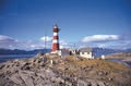
English: Skrova Lighthouse
lighthouse in Norway  | |||||
| Upload media | |||||
| Instance of | |||||
|---|---|---|---|---|---|
| Made from material | |||||
| Location | Vågan Municipality, Nordland, Norway | ||||
| Located in or next to body of water | |||||
| Heritage designation |
| ||||
| Inception |
| ||||
| Significant event |
| ||||
| Height |
| ||||
 | |||||
Media in category "Skrova fyr"
The following 6 files are in this category, out of 6 total.
-
 Lofoten - 20120601 050.JPG 2,848 × 4,288; 5.46 MB
-
 Lofoten - 20120601 051.JPG 2,848 × 4,288; 3.98 MB
-
 Skrova fyrstasjon, Saltværsholmen NFL 7476.tif 1,063 × 700; 2.15 MB
-
 Skrova, Skjåholmen, Vågan - S-1602U3 067.jpg 4,000 × 3,071; 3.24 MB
-
 Skrova, Skjåholmen, Vågan - S-1602U3 068.jpg 4,000 × 3,142; 2.7 MB
-
 Skrova, Vågan - S-1602U6 1 39.jpg 4,000 × 3,014; 2.84 MB


Categories:
- Lighthouses in Lofoten
- Skrova
- Lighthouses built in 1922
- Built in Norway in 1922
- Lighthouses by height, 21 to 30 meters
- Cast-iron lighthouses in Norway
- Buildings in Vågan
- Cultural heritage monuments in Vågan
- Lighthouses in Norway by name
- Red and white lighthouses in Norway
- Lighthouses by range, 15 to 19 nm
- Landfall lights