Category:Skurweberg, Gauteng
Jump to navigation
Jump to search
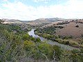
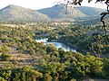
Afrikaans: Ook bekend as Schurveberg of Kalkheuwel, 'n rand suid van die Magaliesberg (en Witwatersberg), benoorde die Wieg van die Mensdom. Geologies word dit oorheers deur blouklip, ingewig tussen die dolomitiese glooiings van die Wieg suidwaarts, en skalies ten noorde. Die rand oorkruis die grenslyn tussen Gauteng en Noordwes-provinsies.
English: Also known as Schurveberg or Kalkheuwel, a range south of the Magaliesberg (and Witwatersberg) and north of the Cradle of Humankind. Its geology is dominated by chert, flanked by the dolomitic undulations of the Cradle to the south, and shale to the north. It straddles the boundary between Gauteng and North West provinces, South Africa.
| Object location | | View all coordinates using: OpenStreetMap |
|---|
mountain in Gauteng, South Africa  | |||||
| Upload media | |||||
| Instance of | |||||
|---|---|---|---|---|---|
| Location | Gauteng, Transvaal region | ||||
 | |||||
Media in category "Skurweberg, Gauteng"
The following 4 files are in this category, out of 4 total.
-
 Crocodile River (Limpopo), South Africa.jpg 3,696 × 2,448; 3.9 MB
-
 Krokodilrivier, a, Phalandingwe.jpg 4,000 × 3,000; 4.03 MB
-
 Krokodilrivier, c, Phalandingwe.jpg 4,000 × 3,000; 4.09 MB
-
 Krokodilrivier, d, Phalandingwe.jpg 4,000 × 3,000; 3.66 MB
,_South_Africa.jpg)

