Category:Smeesteeg 21, Elburg
Jump to navigation
Jump to search
| Object location | | View all coordinates using: OpenStreetMap |
|---|
 | |||||
| Upload media | |||||
| Instance of |
| ||||
|---|---|---|---|---|---|
| Location | Elburg, Gelderland, Netherlands | ||||
| Street address |
| ||||
| Located on street |
| ||||
| Heritage designation |
| ||||
 | |||||
|
This is a category about rijksmonument number 14850
|
| Address |
|
Media in category "Smeesteeg 21, Elburg"
The following 5 files are in this category, out of 5 total.
-
 RM14850 Smeesteeg 21.JPG 2,676 × 4,257; 2.53 MB
-
 Smeesteeg 21 na restauratie.JPG 2,592 × 3,888; 3.88 MB
-
 Smeesteeg 21 voor restauratie.JPG 2,592 × 3,888; 1.26 MB
-
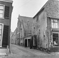 Tussen Smedestr.-Vispoortstr. overzicht - Elburg - 20069223 - RCE.jpg 1,200 × 1,180; 356 KB
-
 Tussen Vispoort-Smedenstr. - Elburg - 20069222 - RCE.jpg 957 × 1,200; 236 KB


