<nowiki>Sorgeat; Sorgeat; Sorgeat; Sorgeat; Sorgeat; Sorgeat; Sorgeat; Sorgeat; Sorgeat; Sorgeat; Sorjat; 索爾雅; Sorgeat; Sorgeat; Sorgeat; Sorgeat; Sorgeat; Sorgeat; Sorgeat; Sorgeat; Sorgeat; Sorgeat; Sorgeat; Sorgeat; Sorgeat; Sorgeat; Sorgeat; Sorgeat; Sorgeat; Sorgeat; Sorgeat; Sorgeat; Sorgeat; Sorgeat; 索尔雅; Sorgeat; Sorgeat; Соржа; Sorgeat; Sorgeat; Sorgeat; 索爾雅; Sorgeat; Соржат; Sorgeat; Соржа; Sorgeat; Sorgeat; СогӀжа; Sorgeat; Սորժա; 索尔雅; Sorgeat; Sorgeat; Sorgeat; Sorgeat; Sorgeat; Sorgeat; Sorgeat; Sorgeat; Sorgeat; Sorgeat; Sorgeat; Sorgeat; Sorgeat; Sorgeat; Sorgeat; Sorgeat; Sorjat; Sorgeat; Sorgeat; Sorgeat; Sorgeat; Sorgeat; Sorgeat; Sorgeat; Sorgeat; Sorgeat; Sorgeat; Sorgeat; Sorgeat; Sorgeat; Sorgeat; Sorgeat; Sorgeat; Sorgeat; Sorgeat; Sorgeat; Sorgeat; Sorgeat; Sorgeat; Sorgeat; Sorgeat; Sorgeat; Sorgeat; Sorgeat; Sorgeat; Sorgeat; Sorgeat; Sorgeat; Sorgeat; comuna francesa; commune française du département de l'Ariège; municipi francès; sveitarfélag í Frakklandi; 法国市镇; بلدية في فرنسا; kommune i Ariège i Frankrike; коммуна во Франции; kumun Bro-C'hall; französische Gemeinde im Département Ariège; comuna francesa; komunë në departamentin Ariège, Francë; chemun de la Franzia; 法国阿列日省市镇; Gemeen in dat Département Ariège, Frankriek; Fransa'da komün; obec v departemente Ariège vo Francúzsku; gemeente in Ariège, Frankrijk; una comuna francesa; fransk kommun i departementet Ariège; miejscowość i gmina we Francji; муніципалітет у департаменті Ар'єж, Франція; komune di Peurancih; 法國市鎮; comun fransexo; französeschi Gmaind im Département Ariège; település Franciaországban; commune in Ariège, France; komunumo en la departemento Ariège de Francio; obec v departementu Ariège ve Francii; comune francese; Sorgeat; Jean-Marc Herreros</nowiki>


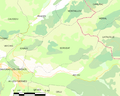 Map commune FR insee code 09298.png 756 × 605; 52 KB
 Population - Municipality code 09298.svg 475 × 355; 12 KB
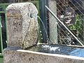 Sorgeat font1.JPG 1,600 × 1,200; 626 KB
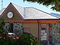 Sorgeat mairie.JPG 1,600 × 1,200; 493 KB
 Sorgeat monu.JPG 1,600 × 1,200; 744 KB
 Sorgeat sf.JPG 1,600 × 1,200; 538 KB
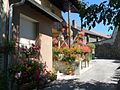 Sorgeat street.JPG 1,600 × 1,200; 562 KB


